| Hurricane Nicole coverage: Monday | Tuesday | Wednesday | Thursday | Damage assessment, Part I | Damage assessment, Part II | A1A Reopens |
Last Updated: 5:56 p.m.
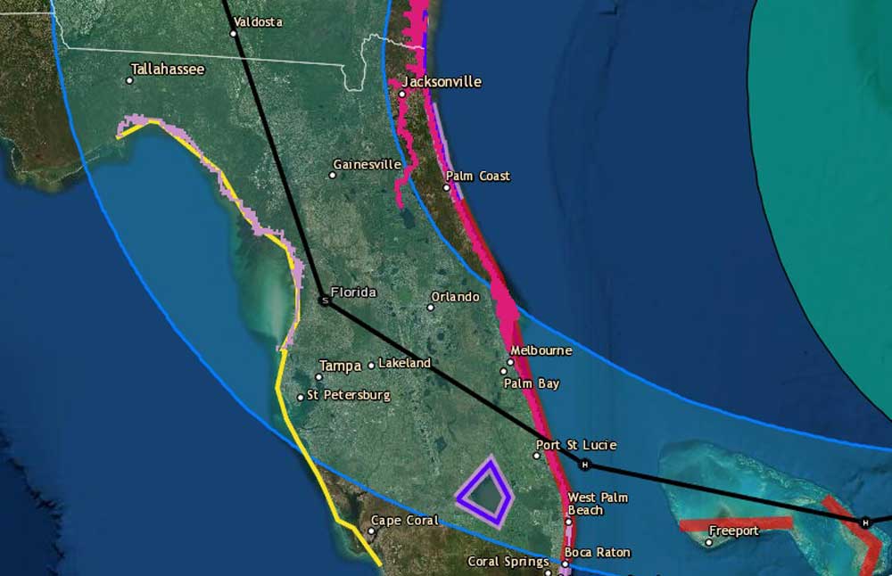
Tuesday, 5:56 p.m.–Tropical Storm Nicole was approaching hurricane strength Tuesday evening but its predicted path has yet again wobbled slightly south, with projected landfall at 1 a.m. Thursday as a Category 1 hurricane around Port St. Lucie.
The latest shift has moved Palm Coast and the barrier island out of the cone of probability for landfall. But coastal Flagler remains under a hurricane watch, and all of Flagler remains under a tropical storm watch, as the storm may yet pass over portions of Flagler, to the west.
The National Hurricane Center issued its latest advisory less than an hour after Flagler emergency officials and school officials announced evacuation plans for the barrier island, and school closure plans starting between noon and 2 p.m. Wednesday. If the storm’s path remains as southerly as it is now, Palm Coast and the county will be largely spared. But effects on the shoreline remain dangerous, as the surf is still expected to generate dune-topping waves and violent erosion against a dune system that has largely vanished. Rain and localized flooding is still a concern for Flagler officials–and residents.
The evacuation orders are not to be in effect until Wednesday afternoon at 3 p.m., giving emergency officials in Flagler time to adjust the orders if necessary.
Meanwhile local governments and courts were issuing a series of advisories about closures and cancellations.
All court operations at the Flagler County courthouse will be closed Wednesday through Friday. Court operations in POutnam and St. Johns will close Thursday and Friday.
In Palm Coast, Waste Pro garbage collection for Thursday, November 10, has been cancelled. Yard debris collection will take place on Wednesday, as usual. There should be no debris left outside by 6 p.m. Wednesday evening. Residents are encouraged to bring their garbage cans inside the garage or secured for the duration of the storm.
The Flagler Beach City Commission has postponed its next meeting, originally scheduled for Thursday, to the following Thursday, Nov. 17. A ceremony at veterans Park scheduled for Friday, to commemorate Veterans Day and a new fountain there, has been postponed, without a new date announced.
Previous updates are below.
Tuesday 3:15 p.m. updates: Flagler County Emergency Management’s Jonathan Lord is ordering the barrier island from Flagler Beach to Marineland evacuated starting at 3 p.m. Wednesday, ahead of Tropical Storm Nicole. He said the storm has a slightly higher chance of striking Flagler as a Category 1 hurricane.
“It is potentially a Category 1 hurricane at landfall, Flagler County is well within the cone” of possibility for such a strike, he said.
Flagler County schools will run an abbreviated day Wednesday, with middle schools busing home at noon, the high schools closing at 1 p.m. and the elementary schools closing at 2. Schools will be closed Thursday, and were scheduled to be closed Friday, in observance of Veterans Day.
After-school activities Wednesday have been cancelled. Extended day for elementary age students will still be held, but the district is asking parents to pick up their children no later than 4 p.m.
Rymfire Elementary will be the county’s only shelter, combining special needs, general population and pets.
The early release and Thursday closure will necessitate a hurricane make-up day, Superintendent Cathy Mittlestadt said–but likely just one day, not two. When that make-up day will take place has not yet been determined.
Volusia County schools and administrative offices will be closed Wednesday and Thursday, as will be Daytona State College at all campuses, and the University of Central Florida at all campuses. Flagler College is moving to remote classes for the rest of the week.
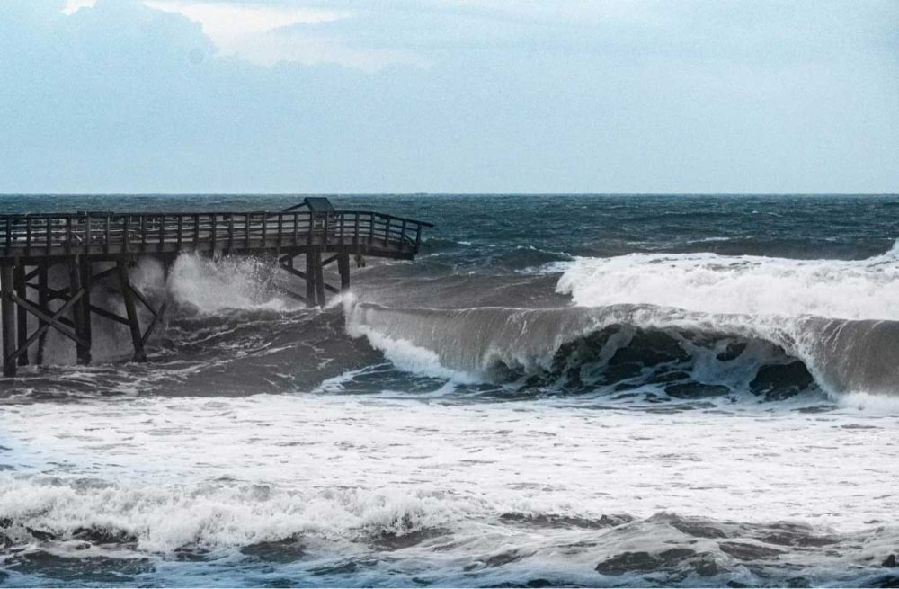
Lord said waves could approach 15 feet on Thursday, higher offshore. Due to previous damage of dunes, “we have a real risk of significant coastal impacts,” including flooding past the dunes. He said the county has been reinforcing dunes in some sectors, with more sand. There were three or four such spots after Ian.
Lord said the Flagler Beach pier is almost certain to be further damage. The pier lost 125 feet of its eastern end during Hurricane Ian. Engineers who analyzed the structure since said another 125 feet should have been removed anyway, because it’s teetering. That span may well collapse.
Lord and Mittlestadt provided the update at a 3 p.m. press conference at the Emergency Operations Center.
AdventHealth Palm Coast is not altering its normal schedules and operations. The hospital issued the following internal directive this afternoon: “As of the afternoon of Tuesday, Nov. 8, AdventHealth Palm Coast is not planning to activate Team A / B. All team members should continue to report at their normal scheduled shift.”
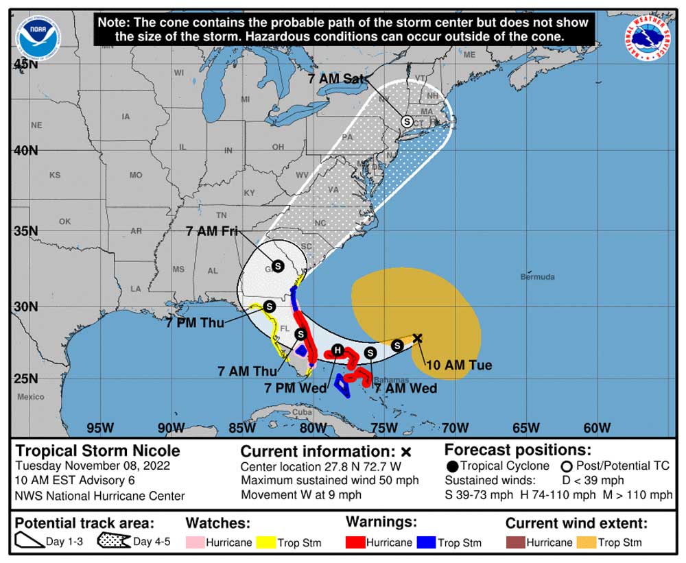
Tropical Storm Nicole’s Path Has All of Flagler In Probability Cone, Hurricane Watch Issued for Coast
For Flagler County, Tropical Nicole–it ditched the “sub” part this morning–may turn into a tale of two storms: rougher, more hazardous and more damaging on the barrier island, but possibly not as violent on the mainland, though rain amounts may be closer to 6 inches for much of the county–half or less than the amounts dropped by Hurricane Ian.
But the storm’s path has been edging closer to Flagler County, not further away. A hurricane watch was issued for the Flagler County coast late this morning. A tropical storm warning is also in effect for Flagler.
“The path has shifted north and east, which doesn’t really change much for us other than the potential for a Category 1 storm has slightly increased,” Jonathan Lord, Flagler County’s emergency management director, said this morning. “Before I would have said it was basically a zero chance. Now there’s a slight chance. Doesn’t mean it’s going to happen, but it still means there’s a chance, and I have to keep that in my realm of possibilities as we analyze what we’re going to do the next 24-36 hours. That’s kind of changed my thought process a little bit.”
Heightening Lord’s concern is the fact that as Nicole’s path solidified overnight, “we are fully inside the cone,” Lord said, referring to the National Hurricane Center’s cone of probability. That means the hurricane’s path can go anywhere in that cone. The storm can either land closer to Flagler, or even in Flagler, and go inland or land further south and swing west. “At this point in time it doesn’t really matter other than one option gives us a little bit more time than the other, but I’m not going to gamble with people’s lives, and we will lock into whatever the safest option is,” Lord said.
Lord stresses: do not focus on the center point of the storm’s path. That’s the mistake Lee County officials made on Florida’s west coast, where Hurricane Ian shifted just enough south to ravage that county and cause a death toll there that has reached 61, almost half the total of Ian’s fatalities, and the most (for the whole storm) since 1934 for any given hurricane in Florida.
With Nicole that far out at the moment–at 10 a.m. today it was about 350 miles northeast of the Bahamas, churning with sustained winds of 50 mph and moving west at 9 mph–the slightest shift north could reconfigure the path into an eventually direct hit on Flagler. The county must have enough time to prepare. The slightest shift could also mean that Flagler is spared all but the effects of a sustained summer storm, when all businesses and schools can operate safely. That leaves local officials in a cone of their own–of uncertainty.
The messaging in Flagler remains what it was on Monday: the barrier island from Flagler Beach to Marineland is all but certain to get the evacuation call Wednesday, with a shelter opening that day. Peak surge is forecast to be between 3 and 5 feet along the coast. Lord is likely to tell residents today at 3 p.m. that they should be ready to start leaving the next day (“we would put everybody on high alert later this afternoon,” he said) with the official evacuation order issued Wednesday morning. The county has scheduled a 3 p.m. press conference on the storm.Lord could not speak to the status of school closures, but it would be unusual for an evacuation order to be issued starting at noon on a given day while school is still in session.
Jason Wheeler, the school district’s chief spokesman, said the district hopes to have a decision around midday or not too long after that. He said the district was dealing with “a lot of moving parts” and “making plans for a lot of possibilities.” That could mean different things: early dismissal for all students on Wednesday, or a full day of classes on Wednesday but no afterschool and extended day activities, it could mean an alternate schedule for Thursday.
School buses cannot go on their routes if winds are at sustained speeds of 35 mph or higher. (For emergency vehicles, it’s 45 mph.) There will be gusts reaching tropical storm force winds on the mainland, but sustained winds aren’t expected to be much past the 20 and 30 miles per hour variety, says Lord.
The district is focused on balancing the importance of continuing instructional time with safety. It does not want to end up cancelling school on a day that could end up being nothing more than a summer storm.
Lord echoes that possibility for parts of the county anyway. “I’m pretty sure with Ian, there were people probably in Palm Coast, standing outside their house going, I don’t know what all the hubbub is about this,” he said. “And I think we’re going to be in a similar scenario. There’s going to be parts of the county where people go, I don’t know what all the hubbub is.” Still: with Nicole’s path moving closer to Flagler, it appeared inconceivable that the district would not take safety measures at least 24 hours ahead of landfall. That would make operating schools on Wednesday unlikely.
But the district, like emergency management, also cannot gamble. Either way, the district wants to make a decision as early as possible to give parents time to plan.
As of this morning’s forecast, tropical storm force winds are expected in Flagler Wednesday evening, between 6 and 8 p.m. The probability of tropical storm force winds is in the 70 to 80 percent range for Flagler, especially for the coast.
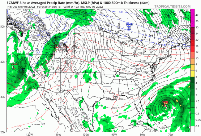
“They’re still thinking tropical storms for us,” Lord said of the latest forecasts. “Again, the highest winds being at the coast and inland the winds will be a little lower even though inland is closer to what would be considered the eye. In the open water it means the wind is less obstructed. This is a very wide storm. They called it a blob a few days ago. It’s still a blob of a storm.” The storm’s tropical-storm-force winds extend 380 miles from the center, according to the National Hurricane Center’s latest measurements.
“So its core is not the same as a traditional core,” Lord continued. “At landfall it might be, but because of the way it spreads out and the way it meanders, and the fact that the storm will be interacting with this warm front that’s coming down that’s causing some of the easterly, northeasterly winds that we’re already seeing, just like Ian ended up being somewhat of a hybrid storm, like a nor’easter mixed with with a tropical storm for us.” The same could happen with Nicole.
Because of Nicole’s strange structure, Lord said, the storm will be double-faced all around: there will be a difference between the violence on the coast as opposed to the less severe effects on the mainland. But there will also be a split in winds: the winds’ strongest effects will be late Wednesday into Thursday, but the rain will be Thursday into Friday.
“Our community did extremely well with 15 inches, amazingly well with 15 inches of rain with Ian,” Lord said. “So this is half, potentially less than half of what Ian did. And we’ve been drying out since Ian, so we do have a lot of capacity to absorb rainwater.”
When the evacuation order is issued, the county will have to have an emergency shelter ready to receive residents. There are two possibilities: The Palm Coast Community Center on palm Coast Parkway, which is roomy and has a new electrical generator, but, unlike schools, does not have both a cafeteria and a kitchen staff. That leaves the possibility of a school being used as a shelter still on the table, Lord said. Usually, Rymfire Elementary is the first shelter to open, because it is the special-needs shelter. In this case, if and when a shelter opens, it will likely combine special needs and general population. The discussions are ongoing.
“Strengthening is expected during the next 36 to 48 hours,” the National Hurricane Center said in its 10 a.m. forecast, “and Nicole is forecast to be near or at hurricane strength by Wednesday and Wednesday night while it is moving near the northwestern Bahamas and approaching the east coast of Florida.”
In preparation for Nicole, the City of Palm Coast will have sand and sandbags available for residents at the Indian Trails Sports Complex, 5455 Belle Terre Parkway, beginning at 11 a.m. on Tuesday, and will remain open until 3:30 p.m. Palm Coast sand stations are self-serve and residents should bring a shovel and be prepared to fill the bags. There is a limit of ten bags per vehicle.
Here’s the latest Tropical Storm Nicole briefing from the National Weather Service in Jacksonville:
nws-jax-briefing (2)Previous Nicole coverage here.





Nick Gerz says
My son lives on the island of Flagler beach and needs to know if Flagler beach is getting evacuated on the island side
FlaglerLive says
Yes it is. 3 p.m. Wednesday.
J Reynolds says
I would rather eat a toilet full of diarrhea than deal with another climate change fueled hurricane