NOAA’s Climate Prediction Center is forecasting a near-normal or below-normal season in its 2014 Atlantic hurricane season outlook. The forecast closely squares with the annual Colorado State University forecast.
The main driver of this year’s outlook is the anticipated development of El Niño this summer. El Niño causes stronger wind shear, which reduces the number and intensity of tropical storms and hurricanes. El Niño can also strengthen the trade winds and increase the atmospheric stability across the tropical Atlantic, making it more difficult for cloud systems coming off of Africa to intensify into tropical storms.
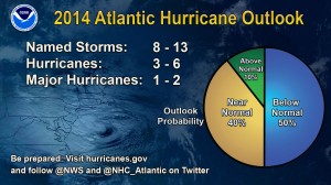
The outlook calls for a 50 percent chance of a below-normal season, a 40 percent chance of a near-normal season, and only a 10 percent chance of an above-normal season. For the six-month hurricane season, which begins June 1, NOAA predicts a 70 percent likelihood of 8 to 13 named storms (winds of 39 mph or higher), of which 3 to 6 could become hurricanes (winds of 74 mph or higher), including 1 to 2 major hurricanes (Category 3, 4 or 5; winds of 111 mph or higher).
Colorado State’s forecasters predict a 20 percent chance of a hurricane landfall on the East Coast, including Florida, and a 19 percent chance of landfall in the Gulf of Mexico.
These numbers are near or below the seasonal averages of 12 named storms, six hurricanes and three major hurricanes, based on the average from 1981 to 2010. The Atlantic hurricane region includes the North Atlantic Ocean, Caribbean Sea and Gulf of Mexico.
“Thanks to the environmental intelligence from NOAA’s network of earth observations, our scientists and meteorologists can provide life-saving products like our new storm surge threat map and our hurricane forecasts,” said Kathryn Sullivan, NOAA administrator. “And even though we expect El Niño to suppress the number of storms this season, it’s important to remember it takes only one land falling storm to cause a disaster.”

Gerry Bell, lead seasonal hurricane forecaster with NOAA’s Climate Prediction Center, said the Atlantic – which has seen above-normal seasons in 12 of the last 20 years – has been in an era of high activity for hurricanes since 1995. However, this high-activity pattern is expected to be offset in 2014 by the impacts of El Niño, and by cooler Atlantic Ocean temperatures than we’ve seen in recent years.
“Atmospheric and oceanic conditions across the tropical Pacific are already taking on some El Niño characteristics. Also, we are currently seeing strong trade winds and wind shear over the tropical Atlantic, and NOAA’s climate models predict these conditions will persist, in part because of El Niño,” Bell said. “The expectation of near-average Atlantic Ocean temperatures this season, rather than the above-average temperatures seen since 1995, also suggests fewer Atlantic hurricanes.”
Colorado State’s forecasters concluded in April: “We anticipate that the 2014 Atlantic basin hurricane season will have below-average activity compared with the 1981-2010 climatology. It appears quite likely that an El Niño of at least moderate strength will develop this summer and fall. In addition, the tropical Atlantic has anomalously cooled over the past few months. We anticipate a below-average probability for major hurricanes making landfall along the United States coastline and in the Caribbean. Despite the quiet forecast, coastal residents are reminded that it only takes one hurricane making landfall to make it an active season for them. They are reminded to prepare the same for every season, regardless of how much or how little activity is predicted.”
NOAA is rolling out new tools at the National Hurricane Center this year. An experimental mapping tool will be used to show communities their storm surge flood threat. The map will be issued for coastal areas when a hurricane or tropical storm watch is first issued, or approximately 48 hours before the anticipated onset of tropical storm force winds. The map will show land areas where storm surge could occur and how high above ground the water could reach in those areas.
Early testing on continued improvements to NOAA’s Hurricane Weather Research and Forecasting model (HWRF) shows a 10 percent improvement in this year’s model compared to last year. Hurricane forecasters use the HWRF along with other models to produce forecasts and issue warnings. The HWRF model is being adopted by a number of Western Pacific and Indian Ocean rim nations.
NOAA’s seasonal hurricane outlook is not a hurricane landfall forecast; it does not predict how many storms will hit land or where a storm will strike. Forecasts for individual storms and their impacts will be provided throughout the season by NOAA’s National Hurricane Center.
“It only takes one hurricane or tropical storm making landfall to have disastrous impacts on our communities,” said Joe Nimmich, FEMA associate administrator for Response and Recovery. “Just last month, Pensacola, Florida saw five inches of rain in 45 minutes – without a tropical storm or hurricane. We need you to be ready. Know your risk for hurricanes and severe weather, take action now to be prepared and be an example for others in your office, school or community. Learn more about how to prepare for hurricanes at www.ready.gov/hurricanes.”
May 25-31 is National Hurricane Preparedness Week. To help those living in hurricane-prone areas prepare, NOAA offers hurricane preparedness tips, along with video and audio public service announcements in both English and Spanish, featuring NOAA hurricane experts and the FEMA Administrator at www.hurricanes.gov/prepare.
NOAA’s outlook for the Eastern Pacific basin is for a near-normal or above-normal hurricane season, and the Central Pacific basin is also expected to have a near-normal or above-normal season. NOAA will issue an updated outlook for the Atlantic hurricane season in early August, just prior to the historical peak of the season.
–NOAA and FlaglerLive


Leave a Reply