• Skip to primary navigation
  • Skip to main content
  • Skip to primary sidebar
MENUMENU
MENUMENU
  • Home
  • About
    • Contact Us
    • FlaglerLive Board of Directors
    • Comment Policy
    • Mission Statement
    • Our Values
  • Live Calendar
  • Submit Obituary
  • Submit an Event
  • Support FlaglerLive
  • Advertise on FlaglerLive (386) 503-3808
  • Search Results

FlaglerLive

No Bull, no Fluff, No Smudges

MENUMENU
  • Flagler
    • Flagler County Commission
    • Beverly Beach
    • Economic Development Council
    • Flagler History
    • Mondex/Daytona North
    • The Hammock
    • Tourist Development Council
  • Palm Coast
    • Palm Coast City Council
    • Palm Coast Crime
  • Bunnell
    • Bunnell City Commission
    • Bunnell Crime
  • Flagler Beach
    • Flagler Beach City Commission
    • Flagler Beach Crime
  • Cops/Courts
    • Circuit & County Court
    • Florida Supreme Court
    • Federal Courts
    • Flagler 911
    • Fire House
    • Flagler County Sheriff
    • Flagler Jail Bookings
    • Traffic Accidents
  • Rights & Liberties
    • Fourth Amendment
    • First Amendment
    • Privacy
    • Second Amendment
    • Seventh Amendment
    • Sixth Amendment
    • Sunshine Law
    • Third Amendment
    • Religion & Beliefs
    • Human Rights
    • Immigration
    • Labor Rights
    • 14th Amendment
    • Civil Rights
  • Schools
    • Adult Education
    • Belle Terre Elementary
    • Buddy Taylor Middle
    • Bunnell Elementary
    • Charter Schools
    • Daytona State College
    • Flagler County School Board
    • Flagler Palm Coast High School
    • Higher Education
    • Imagine School
    • Indian Trails Middle
    • Matanzas High School
    • Old Kings Elementary
    • Rymfire Elementary
    • Stetson University
    • Wadsworth Elementary
    • University of Florida/Florida State
  • Economy
    • Jobs & Unemployment
    • Business & Economy
    • Development & Sprawl
    • Leisure & Tourism
    • Local Business
    • Local Media
    • Real Estate & Development
    • Taxes
  • Commentary
    • The Conversation
    • Pierre Tristam
    • Diane Roberts
    • Guest Columns
    • Byblos
    • Editor's Blog
  • Culture
    • African American Cultural Society
    • Arts in Palm Coast & Flagler
    • Books
    • City Repertory Theatre
    • Flagler Auditorium
    • Flagler Playhouse
    • Flagler Youth Orchestra
    • Jacksonville Symphony Orchestra
    • Palm Coast Arts Foundation
    • Special Events
  • Elections 2022
    • Amendments and Referendums
    • Presidential Election
    • Campaign Finance
    • City Elections
    • Congressional
    • Constitutionals
    • Courts
    • Governor
    • Polls
    • Voting Rights
  • Florida
    • Federal Politics
    • Florida History
    • Florida Legislature
    • Florida Legislature
    • Ron DeSantis
  • Health & Society
    • Flagler County Health Department
    • Ask the Doctor Column
    • Health Care
    • Health Care Business
    • Covid-19
    • Children and Families
    • Medicaid and Medicare
    • Mental Health
    • Poverty
    • Violence
  • All Else
    • Daily Briefing
    • Americana
    • Obituaries
    • News Briefs
    • Weather and Climate
    • Wildlife

Soon-To-Be Tropical Storm Humberto to Echo Dorian Path Up Florida Coast This Weekend

September 13, 2019 | FlaglerLive | 7 Comments

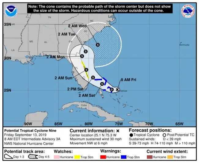
The tropical storm is now expected to go up the Florida coast over the weekend.

National Hurricane Center forecasters expect the weather system they’re calling a “tropical disturbance” to move over the Bahamas today and turn into Tropical Storm Humberto either later today or overnight, then head for a path up or near the Florida coast.


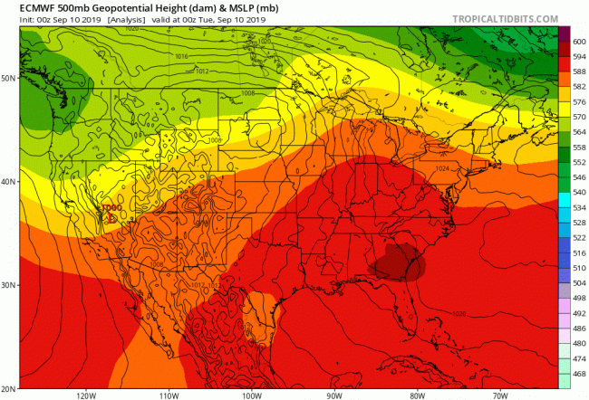
While the current cone encompasses all of northeast Florida, the path of the storm still has a considerable degree of uncertainty. The European model of forecasting that has proven consistently more accurate than the American model–and that the National Hurricane Center has tracked with about a 12 to 24-hour lag–is showing the path of the storm pulling off to sea much as Hurricane Dorian did (and as the European model predicted for that storm).

“We have this strange thing called the potential tropical cyclone number nine,” Jonathan Lord, Flagler’s emergency management chief, said this morning on WNZF. “What that is, is the hurricane center is very confident that it will be a tropical cyclone or depression or storm very soon, and it’s so close to our coastline that they want to call it something in advance of when they’d normally would. So my expectation is later today at a bare minimum we’ll see Tropical Depression Number 9 named, or named as Tropical Storm Humberto–the silent h–is the most likely possibility. The counties to our south are already under a tropical storm watch, starts literally at the Flagler-Volusia line and heads south for three or four counties.”
tropical storm humberto
ECMWF, the European Centre for Medium-Range Weather Forecasts, shows the storm staying offshore. Click on the image to see the animation as the storm moves over the next few days.
Lord said Flagler is “very likely to see tropical storm type impacts all day on Saturday and maybe a little bit into Sunday morning. We’re expecting probably sustained, low-end tropical storm force winds, so less than 54 miles an hour or so, maybe some gusts higher. We’re not looking at a significant storm surge. We may have some minor flooding with this. So we’re not looking to do any evacuations as it sits at this current forecast. Now, we do want people to be well aware of this, to be prepared., For those who have patio furniture and loose items outside, it’s definitely the time to put those away again. Maybe they didn’t get taken back out since Dorian anyway, so it’s good to put those things away so they don’t become projectiles, and for folks to be aware of this approaching storm event.”

The tropical storm watch currently extends to Jupiter inlet. The heavy rainfall potential has shifted to coastal locations for this weekend and early next week, with further adjustments possible based on the track of the storm.

This morning the storm was moving slowly northwest, at 6 mph, with maximum winds of just 30 mph.

The National Hurricane Center this morning acknowledged the differing forecast models, paying heed to the European Centre for Medium-Range Weather Forecasts, or ECMWF: “The track guidance indicates that the disturbance will move generally northwestward for 48 h or so, followed by a turn to the north and eventually to the northeast as the system moves through the weakness in the ridge,” the center stated. ” There is some spread in the guidance, with the GFS model taking a weaker system into the Florida peninsula while the UKMET and ECMWF models show a stronger cyclone farther offshore. Overall, there has been an eastward shift of the guidance since the previous advisory, especially after 72 h. The new forecast track is thus also nudged a little to the east and now calls for the system to spend less time over the Florida peninsula than previously forecast.”

The previous update is below.

Should You Be Worried About the Next Tropical Disturbance? ‘Considerable Uncertainty’ Grids All Florida

That’s why they call it peak hurricane season. Many Flagler and Florida residents aren’t yet done wiping their brows Hurricane Dorian’s week-long anxieties, or finding ways to help residents of the Bahamas recover. But the National Hurricane Center is tracking so-called “Tropical Disturbance Invest 95L,” now southeast of the Bahamas, and placing the chance at 80 percent that the system will turn into a tropical storm or depression within the next five days, and a 70 percent chance that it will do so in the next 48 hours.


Its track’s cone of uncertainty now includes almost all of Florida except western portions of the Panhandle–just as Dorian had at various points in its indecisive whirl earlier this month.

“There is now considerable uncertainty with regards to the future movement of Invest 95L, and this disturbance may directly threaten our region by late in the weekend,” Ben Nelson of the National Weather Service in Jacksonville said this morning. He published his morning briefing at 6 a.m. At the time, the system had a 70 percent chance of turning into a tropical storm. That chance was bumped up to 80 percent two hours later, with the National Hurricane Center’s 8 a.m. report.
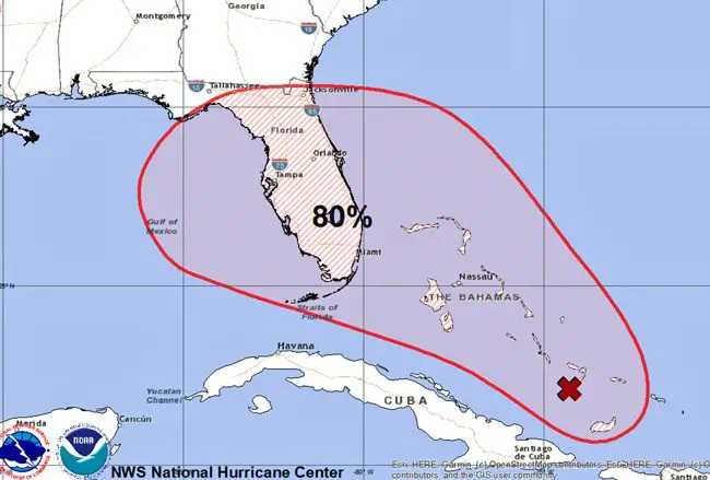
Humberto possibly in the making, again threatening the Bahamas. Click on the image for larger view. (NHC)
“Tropical development is expected by Friday or the weekend as this disturbance moves slowly northwestward towards south Florida,” Nelson reported. He is forecasting a high risk of deadly rip currents starting Friday as breezy onshore winds persist and surf builds, and the potential “for at least minor tidal flooding” increasing along the Florida Atlantic coast and the St. Johns basin over the weekend. “Heavy rainfall potential this weekend and early next week, with amounts highly dependent on the track of Invest 95L.” (An “invest” is a weather system of special interest to the National Hurricane Center’s analysts, not the precursor of a name. The next named tropical storm on the list is either Humberto or Imelda. Gabrielle formed into an organized storm last week but veered north in the middle Atlantic and dissipated. The remains of Dorian are actually still active just northeast of Newfoundland, and heading east, south of Greenland, as a subtropical depression, as you can see from this NHC track.)

Regarding this weekend’s outlook, most of Flagler County was in the 3 to 4 inch range for rainfalls, with the northeast quadrant of the county in the 4 to 6 inch range, though all that could change as the storm moves. The system is currently moving at 5 to 10 mph, straight for areas already devastated by Dorian. “This disturbance will bring heavy rainfall and gusty winds across portions of the Bahamas through Friday, especially in portions of the northwestern Bahamas affected by Hurricane Dorian,” the NHC reports.

That’s not all. The center is also tracking a “tropical wave” west of the Cabo Verde Islands. “Conditions appear conducive for development, and a tropical
depression could form early next week while the system moves westward over the tropical Atlantic,” the center states, with chances for formation at 40 percent over the next five days.

See the Jacksonville National Weather Service station’s latest briefing on the storm below.

Click to access nws-jax-briefing-11.pdf

Print Friendly, PDF & Email
You and your neighbors collectively read our articles about 25,000 times each day (that's not a typo) with up to 65,000 daily reads during emergencies like hurricanes. Flagler County residents rely on FlaglerLive for essential, bold and analytical journalism that cannot be found anywhere else. But we depend on your support. Please join our December fund drive! If you donate the cost of a scoop of ice cream, you will be helping us continue to provide comprehensive local news and honest, serious journalism for our community. If you can donate more or become a monthly donor, even better. Donations are tax deductible since FlaglerLive is a 501(c)(3) non-profit news organization. Donate by clicking anywhere in this box. Think of it as buying a scoop, in every sense of the term!  
All donors' identities are kept confidential and anonymous.
   

Reader Interactions

Comments

  1. Greg Jolley says

    September 12, 2019 at 10:05 am

    Great coverage and thank you – this is the first I’ve heard about the latest “disturbance.”
    Greg

    Reply
  2. Don Appignani says

    September 12, 2019 at 10:18 am

    Uh Oh! Look out Alabama!

    Reply
  3. David Dennison says

    September 12, 2019 at 1:53 pm

    As you know, and many people tell me, this will be the greatest tropical depression in the history of our country, perhaps all of history. If not for those Venezuela loving socialist Democrats, Precedent Trump would have finished his wall around Florida to protect us from invading storms. Storms created. by Democrats so more illeagle immgrants can come here. Covfefe’

    Reply
  4. palmcoaster says

    September 12, 2019 at 5:25 pm

    Maybe this one may reach Alabama..? Do some at the helm do even know about our USA map or just know how to increase their wealth with our hard earned taxes?

    Reply
  5. Shaggy Rogers says

    September 12, 2019 at 9:19 pm

    I’ll remain optimistic for now. We may see a few days of peace and quiet. The multiple flight schools from Daytona and Flagler airport that continuously buzz around our homes in PC maybe temporarily suspended. As a result, the air that we breathe will be free from any lingering leaded aviation emissions from piston-engine aircraft. I can feel my IQ jump a few points already! With any luck, this storm won’t develop into anything major.

    Reply
  6. Mark says

    September 12, 2019 at 10:53 pm

    Exactly what I was thinking. Alabama.

    Reply
  7. Agkistrodon says

    September 13, 2019 at 10:38 am

    Yuck it up, til it smacks you hard. Probably not too smart or respectful to those who are still struggling from Dorian, and for the record, MOST have still seen NOTHING of the Bahamian Govt, but the US is still there. People living under propped up remains of their destroyed homes, but go on and yuck it up…….SAD.

    Reply
  • grand living realty
  • politis matovina attorneys for justice personal injury law auto truck accidents

Leave a Reply Cancel reply

Your email address will not be published. Required fields are marked *

Primary Sidebar

Advertisers

  • grand living realty
  • politis matovina attorneys for justice personal injury law auto truck accidents

Recent Comments

  • John on Behind the Divorce, a Bitter, Threat-Ridden Clash Between Waste Pro and Palm Coast Over Recycling Bins
  • Wow on Mom Arrested After Witnesses Report her Brutalizing Her 7-Year-Old Child on A1A
  • tulip on Voters Approved an Amendment For Racial Equity in Districts. DeSantis Wants It Ignored.
  • Fritz B. on Palm Coast Fines Waste Pro $125 For Every Recycling Bins It’s Taking Back and Threatens Litigation
  • Bradley Boyd on Its Streets Degrading, Palm Coast Looks for Electric Vehicles to Pay Their Fair Share of Road Taxes
  • tulip on Palm Coast’s Belk Converted Into One of 16 Outlet Stores as Company Struggles
  • The Geode on Voters Approved an Amendment For Racial Equity in Districts. DeSantis Wants It Ignored.
  • Jane Elizabeth K on Behind the Divorce, a Bitter, Threat-Ridden Clash Between Waste Pro and Palm Coast Over Recycling Bins
  • Pogo on The Daily Cartoon and Live Briefing: Friday, June 2, 2023
  • Tax on Liberal Resposibility? on Its Streets Degrading, Palm Coast Looks for Electric Vehicles to Pay Their Fair Share of Road Taxes
  • John Stove on Behind the Divorce, a Bitter, Threat-Ridden Clash Between Waste Pro and Palm Coast Over Recycling Bins
  • Tony on Behind the Divorce, a Bitter, Threat-Ridden Clash Between Waste Pro and Palm Coast Over Recycling Bins
  • Tony on Mom Arrested After Witnesses Report her Brutalizing Her 7-Year-Old Child on A1A
  • Shark on 251-Unit Wilton Apartment Project Breaks Ground in Town Center, Employing 300 During Construction
  • jake on Its Streets Degrading, Palm Coast Looks for Electric Vehicles to Pay Their Fair Share of Road Taxes
  • Kris on 251-Unit Wilton Apartment Project Breaks Ground in Town Center, Employing 300 During Construction

Log in