


Last Updated: 6:57 p.m.
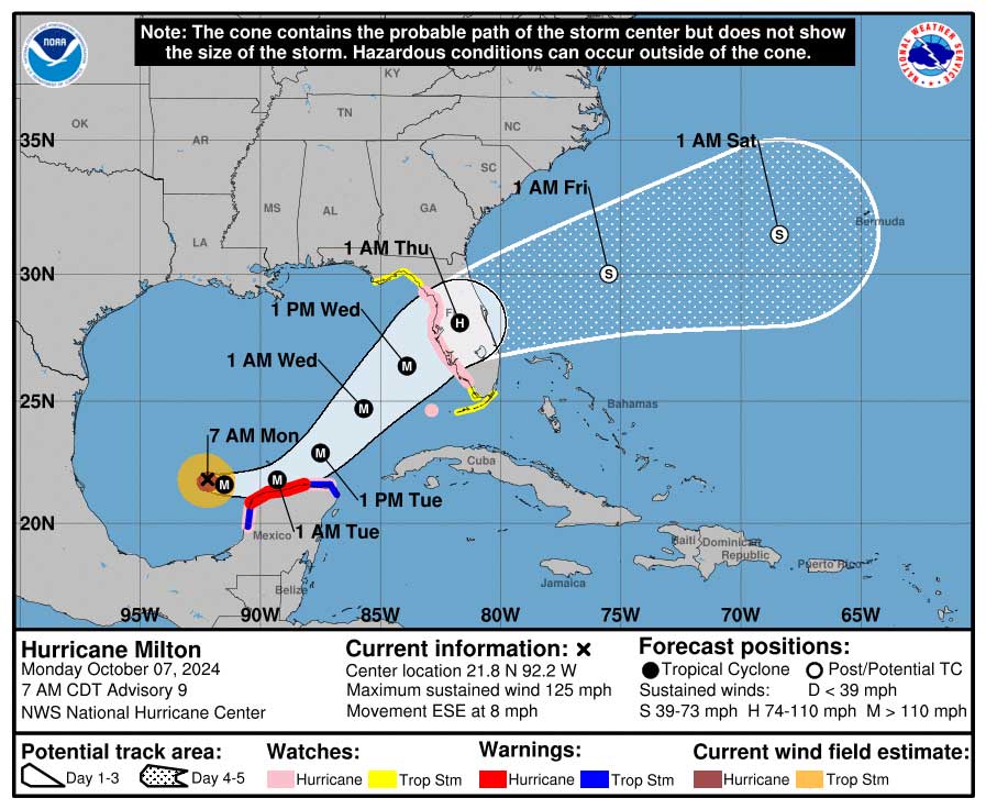
Monday, 6:30 p.m.–Hurricane Milton has broken the National Hurricane Center’s website: interest in the monster Category 5 storm, now with sustained winds of 180 miles per hour–one of the most intense hurricanes ever recorded–had crashed NHC’s site in early evening Monday, as Florida’s midsection was bracing for a direct hit in the Tampa Bay area and Flagler County was preparing for severe impacts and potential hurricane-force winds that it did not record even during Hurricanes Mathew and Ian in 2016 and 2017.
Hurricane Milton went from a Category 2 to a Category 5 hurricane in a matter of hours today. The storm was expected to weaken somewhat before making landfall overnight between Wednesday and Thursday, but also broaden. Flagler County continues to be north of the expected path, especially in the European forecasting model, generally the most accurate of the models. That’s a silver lining for the county. But Flagler will also be on the side of the storm heaviest hit by rain. The county is now under hurricane watch.
Evacuation orders are likely by Wednesday in Flagler County for specific areas, including the entire barrier island–including Flagler Beach and Beverly Beach–from the St. Johns County Line to the Volusia County line, Flagler Beach neighborhoods along Palm Drive, Lambert Avenue , Flagler County and Flagler Beach neighborhoods along John Anderson Highway, and Marina del Palma, Bulow RV Park, and Palm Coast Plantation areas south and north of Riverwalk Drive.
At 4 p.m. Monday, the storm was about 675 miles southwest of Tampa, with sustained winds of 180 miles per hour, moving east at 10 miles per hour. “Milton is a potentially catastrophic category 5 hurricane on the Saffir-Simpson Hurricane Wind Scale,” the National Hurricane Center warns. “Regardless, the system is expected to be a large and powerful hurricane at landfall in Florida, with life-threatening hazards at the coastline and well inland. Residents in Florida should closely follow the orders from their local emergency management officials, as Milton has the potential to be one of the most destructive hurricanes on record for west-central Florida.” Its hurricane-force winds are extending 30 miles from the center, and tropical-storm force winds extending up to 80 miles. That means even if Milton were to cross along the I-4 corridor, Flagler County would experience severe impacts and widespread power outages.
Preparations in Flagler County were continuing on Monday. Courts will be open Tuesday but closed Wednesday and Friday. Flagler County schools will close after classes on Tuesday, with afternoon activities–but not extended day, the school-based child care program–cancelled. Schools will be closed on Wednesday and Thursday. Private schools generally follow the school district’s lead. All local colleges, including Daytona State, the University of Central Florida and the University of North Florida, have cancelled classes starting Tuesday.
Flagler County government and the public library will close Wednesday and Thursday.
In Palm Coast, garbage collection services have been canceled for Wednesday and Thursday. This includes yard debris and recycling. The next pickup day will be the regularly scheduled pickup day.
The City’s Customer Service call center is operating on a 12-hour basis, from 7 a.m. to 7 p.m., with the potential to increase to 24-hour operations until the storm passes. City staff can only assist with city-related issues. If you are experiencing a medical emergency, please dial 911. The Customer Service phone number is 386-986-2360 or residents can submit a case through Palm Coast Connect.
![]()
Hurricane Milton Already Cat 5; Foot of Rain Possible in Flagler, Raising Flooding Concerns; Cancellations Multiply; Sandbag Station Up
Monday, 11 a.m. update–If Hurricane Milton would have more accurately been called Hurricane Maserati: the storm’s sustained winds went from under 100 miles an hour just six hours ago to 155 mph at last check by the National Hurricane Center, or just one mile per hour below Category 5 strength. The Hurricane Center called the rapid intensification “remarkable.”
The center has also nudged its path slightly northward, which bodes ill for Flagler County. The county is fully within the cone of probability, which stretches north almost to the Florida-Georgia border. Local officials and the National Weather Service in Jacksonville are cautioning of the possibility of up to a foot of rain, but that would eb stretched between now and Sunday. Still, grounds are saturated already.
“Milton is forecast to become a category 5 hurricane later today and become a large hurricane over the eastern Gulf of Mexico,” the National Hurricane Center said at 11 a.m., though it may lose some strength just before landfall in Florida on Wednesday night, but the storm is also expected to grow larger by then. Storm surge in Tampa Bay is predicted at 8 to 12 feet.
Palm Coast Mayor David Alfin signed a local emergency declaration at 10 a.m. Officials were following suit in other local cities and the county. Flagler County schools will close Wednesday through Friday.
Sandbag operations:
- Indian Trails Sports Complex, 5455 Belle Terre Pkwy, Palm Coast. This is a self-service station, and residents must be able to fill and load the sandbags into their vehicles. Sand and sandbags are available. Please bring a shovel.
- 100 Fin Way at the corner of Belle Terre Boulevard south of State Road 100. This is a self-service station but assistance will also be provided beginning Monday, October 7, 2024, from 1 p.m. to 6 p.m. and again on Tuesday, October 8, 2024, at 8 a.m.
- Flagler Beach: Santa Maria del Mar Catholic Church, 915 North Central Ave., Monday starting at 9 a.m.
- Flagler Beach Fire Station, 320 South Flagler Avenue, Monday starting at 9 a.m.
- Hidden Trails Community Park in the Mondex, 6180 Mahogany Boulevard, Bunnell, from 10 a.m. to sunset.
- Bay Drive Park, 30 Bay Drive in the Hammock, from 10 a.m. to sunset.
There is not currently a Bunnell sandbag station, but the city is hoping to open one soon. Palm Coast has cancelled the City Council workshop scheduled for Tuesday, the town hall with Council member Theresa Pontieri scheduled for Oct. 10, and a groundbreaking ceremony scheduled for Oct. 10 for the new Fire Station 26. The Flagler Auditorium has cancelled a concert by the St. Augustine Orchestra scheduled for Oct. 10.
Water levels are obviously a concern in Palm Coast and, later this week, along the Intracoastal. Canals in Palm Coast have been lowered to create more capacity. (You can monitor canal levels from your phone or computer here.)
“Definitely the amount of rain is a concern we’re actively monitoring,” Palm Coast Fire chief Kyle Berryhill, who, with City Manager Lauren Johnston, the city’s incident commander for the emergency, said shortly after noon. “Our stormwater team is actually running some modeling so we can be aware of what areas of concern we can keep a close eye on.”
Watching water rise during a severe rain event inevitably creates anxiety, Berryhill said, but the city is engineered in such a way that water will accumulate in yards and on roads on its way to the stormwater system. Those accumulations should not worry homeowners. Water intrusion into homes is a different story. But for all the severe rain events that have drenched the city since its creation in 1999, it has never known widespread instances of home flooding. Those instances have been in the low dozens over the years, at most. Then again, the city has not a Hurricane Milton in the past, either. This will be “a very rare but very significant type of rainfall event,” Berryhill said.
Coastal flooding and runoff flooding are secondary concerns, the fire chief said, recalling water-level rises in the aftermath of Hurricane Irma, when parts of the Woodlands were especially affected. (See: “In Palm Coast’s Woodlands, Water Is Still Rising and Sandbags Are Being Distributed.”)
Residents are urged to be “incredibly conservative with my water usage because anything that goes down the drain is going to add to that capacity that is overfilled right now due to the rain,” the fire chief said. That means delaying runs of laundry and dishwashing and cutting short lengthier showers.
City officials will be monitoring canal levels and neighborhoods “to make sure residents are safe and do everything we can to provide resources and give them notifications if we think something is going to occur that the stormwater system cannot handle,” Berryhill said. To that end, residents are urged to do their own monitoring of local sources of information–the city, emergency management, local media.
Palm Coast’s website has been refocused on the emergency to make it easier for people to have their questions answered. The city’s customer service ranks will also be increased on Tuesday to handle online and phone inquiries.
Possible Evacuations and Evacuation Readiness
Flagler County issued the following advisory early this afternoon: The county does not have any current evacuation orders. However, all residents in the following neighborhoods are urged to prepare for potential evacuations, with more specific information to be announced over the next 2 days.
- Residents living in Mobile Homes and RV’s Countywide
- Coastal / Island Communities
- The entire island from the St Johns County Line to the Volusia County Line
- Marineland through Flagler Beach
- Mainland Communities
- South of SR-100 (Moody Blvd)
- Neighborhoods off John Anderson Hwy
- Neighborhoods off Palm Dr
- Bulow RV Park & Homes, off Old Kings Rd
- Polo Club West / Sweetbottom Plantation properties along Lexington Court / Ashland Way and that back up to the Bulow Creek
- Between SR-100 (Moody Blvd) and Palm Coast Pkwy
- Neighborhoods off Lambert Ave
- In Marina Del Palm the properties along the Intracoastal Waterway / basin
- In Palm Coast Plantation:
- Properties off South / North Riverwalk Drive
- North of Palm Coast Pkwy
- Properties within Princess Place.
- South of SR-100 (Moody Blvd)
Today’s previous update is below.
![]()
Milton Will Strike Florida as Major Hurricane Wednesday, Expected Impacts in Flagler; Local State of Emergency Starts at Noon
Monday, 8 a.m.–Hurricane Milton has rapidly intensified into a Category 3 hurricane in the warm waters of the Gulf of Mexico as it makes its way for landfall Wednesday evening in Florida’s midsection before crossing the state as a hurricane. Models differ significantly as to landfall and direction after that. Forecasters are urging residents not to focus on the track of the storm, but on the cone of probability, with anyone within that cone potentially in Milton’s path.
Flagler County is declaring a state of emergency effective at noon today. It is already under a declared state emergency. County emergency officials are preparing for evacuations targeted to specific areas of the county, should those become necessary, and would have shelters available in that case. Officials will announce later today what areas should be prepared to evacuate–but not actually evacuate–should the storm track continue to include Flagler in its cone.
“Should we order evacuations, they will be done by a neighborhood,” Flagler County Emergency Management Director Jonathan Lord said this morning.
Three days away, the path of the storm has a variability of 100 miles north or south, the National Hurricane Center cautions. “The track guidance is in good agreement that the hurricane will cross the Florida Peninsula, but there remains significant differences in both the location and timing of landfall,” the center states in its Monday morning advisory.
The American model has Milton making landfall between Tampa Bay and the Big Bend area and heading toward the Flagler-St. Johns area. The European model, which historically has been the most accurate, has landfall at or just south of Tampa and crossing the state south of the I-4 corridor. Both of those models predict landfall around 8 p.m. Wednesday. The Canadian model has it making landfall only Thursday morning further south, crossing the peninsula south of Merritt Island.
“This is one of those hurricanes that is not necessarily super easy to model,” Flagler County Emergency Management Director Jonathan Lord said this morning. “They know the general idea. They know it’s heading to the Florida peninsula. At one point in time they had the entire peninsula within the potential cone. And again, the cone is just the area where the center of the storm may be. The storm is going to be hundreds of miles wide and have impacts beyond the center of the storm. But even where the center is going to go has fluctuated a little bit. I guess the only thing that they are sure of, it is somewhere in our vicinity, the center of the storm. If you were to follow the center of a line, it does not necessarily put it directly over us, but again, we’re in that cone, and that center can be anywhere in that cone.”
Audio: Jonathan Lord’s Monday Morning Briefing on Hurricane Milton
Lord said that it is possible that because of the record-high temperatures of the Gulf of Mexico waters, the storm could strike land as a Category 4, with winds of 130 to 156 miles per hour. The storm’s category at landfall matters because that strength will radiate across land as it makes its way through the Peninsula. “So you’ve got to keep that in mind, because the intensity that it does make landfall does impact what it eventually means for us,” Lord said. “The storm will weaken as it moves across the state, heading kind of in a east, northeast sort of path, then potentially heading in our direction. At a minimum, we expect high end tropical storm force winds. The official forecast, if you’re looking at a certain point in Flagler County today, does not show a high risk of hurricane force winds. But there is a distinct risk that we could have hurricane-force winds.”
This is most likely going to be a Wednesday-Thursday storm for Flagler County, though the storm could yet speed up.
“That’s the key thing: I really don’t want our residents to focus on the line in the middle or the dots in the middle of the cone,” Lord said. “That really is just the middle of the cone. It does not mean the eye is going to travel there. And the eye is much larger than a dot. It can go well north of that dot, I can go well south of that.”
He said today is the day for residents to prepare their homes for sheltering. If they need to put up storm shutters, today is the day, he said.
Daytona State College, Stetson University and the University of Central Florida have cancelled in-person and online classes for Tuesday, Wednesday and Thursday. Stetson’s classes close after 1 p.m. Tuesday and will remain closed through Friday. Students are required to return home, seek shelter with friends and family, or stay at a local emergency shelter–not on campus. Stetson’s fall break begins Friday, so classes will not resume until Oct. 14. There will be no university operations at UCF starting Tuesday. Current plans are to resume operations Friday.
The University of North Florida and and Flagler County schools have not yet announced hurricane plans. It is likely–if not certain–that, should Flagler remain in the cone of probability, county emergency officials will follow past practices, opening at least one shelter in one of the schools, while schools would close for part of the week. Local governments were issuing preparatory alerts to residents. “If I was a betting person–obviously, Mother Nature can do whatever he or she wants at this point–but if I was a betting person, I would assume the schools are going to close at some point,” Lord said.
- Create a Hurricane Preparedness Plan: Make sure your family knows what to do before, during, and after a storm.
- Sign Up for ALERTFlagler: Stay informed with emergency notifications from Flagler County’s AlertFlagler system, which provides updates via phone, text, or email.
- Palm Coast Connect: During severe weather, phone lines may experience longer wait times. The fastest way to report concerns or request services is through Palm Coast Connect, where you can submit requests online quickly and efficiently.
- Review Your Evacuation and Flood Zones: In the event of a major storm, the City of Palm Coast may issue evacuation orders for certain areas. Ensure you know your evacuation and flood zone information ahead of time.
- Residents with PEP Tanks: Many homes in Palm Coast rely on Pretreatment Effluent Pumping (PEP) tanks for wastewater management. During a power outage, these tanks cannot pump waste into the sewer system, so it’s important to conserve water to prevent backups.
- PEP Tank Capacity: Your PEP tank can handle a normal day’s water usage during a power outage.
- Backup Power: The City uses generators to power neighborhood pump stations and works with Florida Power and Light to restore electricity to areas with PEP systems as quickly as possible.
- PEP Alarm: If your PEP alarm goes off, press the alarm silence button on the control panel and contact Palm Coast Customer Service at 386-986-2360 or submit a case through Palm Coast Connect.
![]()


Janet Sullivan says
I know you spent extraordinary time working during storms, but this is in the middle of a baby visit. Thank you, Grandpa.
FlaglerLive says
Baby and family had to be rushed to a plane this morning to get them out of the hazard zone.
Samuel L. Bronkowitz says
The spaghetti models as of this morning mostly agree that it’ll hit at least high cat 3/4 with some extending to 5. All of this rain has softened the ground quite a bit, I’d expect lots of trees down and power outages.
Kate Hikes says
Very interesting. ” What ever happens happens!” Very insightful.
JimboXYZ says
Had Alfin left a few more acres of trees this might not be the crisis it is. He approved & built 30+ new dwellings in my immediate residential alone. So the one’s on the back of my property are built on higher ground, that run off ends up puddling in existing homeowner’s back yards. since they’re the government, there is no recourse beyond living in a newly created flood zone and paying outlandish homeowner’s premiums for limited coverage that is short of doing the job. All this to grow immigration & regional relocation. I get notified of new listings on Zillow, what I’m seeing is pre-existing properties that were sold in 2021 & later being flipped 2-3 years later for double what they were bought for in 2021. Then there are the new residential construction 2021-2023 that are being resold, some of those properties never sold in the 1st place. I mean one can see the history, for example, listed for sale in 2023, listing price dropped, removed from listing because nobody could swing the Biden-Harris mortgage rates, back on the market listed at an even higher price a year later. It is what it is, the worst 4 year mess and you’d really have to go back to Carter-Mondale to live thru an equally dismal 4 year reign of terror under any administration. No wonder they found Trump guilty in NY State of 34 counts, they’re after $ 454 million from him that he would have to pay them for actually getting a loan, paying it back on time & with the interest rate of the era. And in the process they tried to keep him from running against Bidn-Harris-Walz every step of the way. Candidly, can Trump even right the 4 years of inflationary fraud & abuse of Biden-Harris ? And what triggers me, the barrage of email spam I get every day to contribute to Harris-Walz so she can do it to us again for at least 4 more years, potentially 8 years. Nobody has 12 years of Democrat power to endure in their lifetimes.
The dude says
So the hurricane is now Biden’s fault as well?
Interesting perspective…
I’d say MAGA’s ability to ignore any of the science around climate change for the last 4 decades has more to do with the size and intensity of today’s storms.
But you do you.
Tony says
Jimbo – the last time I checked – Alfin was a republican !!!
Joe D says
Thank you Flaglerlive for condensing all the local emergency information into one place…makes it easier to track!
Laurel says
Take this one more seriously, folks. I think it will go to Titusville, but we’ll see. Regardless, there is a high possibility of flooding here. If you have a better place to go, do it.
Tony Mac says
Representative Mike Waltz, together with every Republican member of the House, voted against increased funding for FEMA just prior to Hurricane Helene hitting Florida and the Carolinas. Sadly, we can’t vote this guy out of office in this Ruby Red District. But when this storm hits, he’ll be there with his hand out looking for Federal funds. Waltz voted NO…but he’ll take the DOUGH!
Nephew Of Uncle Sam says
James Stockton for the Congressional 6th District if you’re fed up with do nothing Waltz.
Ray W, says
Only right now there is no more “dough” to hand out. Thank you, Tony Mac.
Deborah Coffey says
That’s BALONEY! And, you’ve been had by the liars.
Ray W, says
Hello Deborah Coffey.
You might be right. You might be wrong. Either way, thank you for the comment.
FEMA says it has enough for Helene claims out of the 2023-24 Disaster Relief Fund.
According to FEMA’s Fiscal Year 2025 Funding Requirements request form, FEMA reviewed past catastrophic events to estimate that it will need $25,733 billion to cover the coming year’s anticipated catastrophic events, plus another $3.196 billion to cover new non-catastrophic major disasters. The form was filed with Congress long before Milton formed. A request is only a request. Congress will provide funds (it already has provided some funds for the coming fiscal year), but who knows how much.
Unless Congress acts quickly, FEMA may not have enough for Milton claims, even if FEMA gets everything it asked for. One site says St. Pete-Clearwater-Tampa GMA has 3.2 million residents. Another says 3.5 million. A 12–15-foot surge of water into the bay might flood for miles inland. I heard one estimate on the news that claimed a 15-foot surge if Milton hit Madeira Beach would “overtop” the entire land mass of St. Petersburg. If Milton continues to shift south to Bradenton and Sarasota, these communities are also built on low-lying topography. And that doesn’t account for the damage if the storm tracks up I-4.
Make of this what you will. Me? My younger son lives in St. Pete. He flew out last week to attend a friend’s wedding in Texas and he planned all along to return next week. He is thankfully safe.
Local double taxpayer says
We had FEMA money….ask the government where it all went.
Deborah Coffey says
We still do, but not enough to cover all of the climate change catastrophes. Congress will need to appropriate more money. But, Republicans really don’t like helping people; they only enjoy helping themselves. We’ll see what they do…not too hopeful.
The dude says
Looks like the MAGA bait got one on the hook here…
The FEMA money “went” nowhere. It’s right where it always is. It has NOT been diverted to the pet eating immigrants…
Sherry says
@double. . . Please just STOP spreading Fox/MAGA Misinformation. . . This from the “credible” Associated Press:
Misinformation has spread over the past week in communities hit the hardest by Helene, including that the federal government is intentionally withholding aid to people in Republican areas. Former President Donald Trump and other Republicans have questioned FEMA’s response and falsely claimed that its funding is going to migrants or foreign wars.
Dennis C Rathsam says
Biden/Harris, played santa claus with FEMA money, they took care of thier new friends, the rapests, the murderers, & the terrorists they let enter his country with no vetting! Now Americans will suffer!
FlaglerLive says
Ratham is misleading: “Congress last week approved FEMA’s request to top up its disaster relief fund,” The NYT reports. “That was before Hurricane Milton, and Alejandro N. Mayorkas, the Homeland Security secretary, last week said FEMA needed additional funding from Congress to make it through the hurricane season. Speaker Mike Johnson has declined to call House lawmakers back from the campaign trail for an emergency session to fund hurricane relief and rebuilding.”
Jim says
It must hurt to hide in your little bubble and do everything you can to avoid finding out the truth before spouting garbage.
But I’m not surprised. I hope the city picked up your debris from the last hurricane so you didn’t have to suffer with that. I bet people in NC, TN, VA and SC would be happy if that was the biggest issue they had to face.
FEMA needs more money for future storms and it has nothing to do with any money spent as you spit out. However, you will find (if you look) that Trump did do that during his term (to be used to detain immigrants at the southern border which is something you’d be for so in that case it was okay….).
If you ever do get interested in making statements based on facts, start very slowly. I’m not sure your hate-filled mind could handle it.
The dude says
Our friends Dennis and Jimbo are nothing if not consistent…
John says
Stop watching fake station Fox and turn on a news station that actually reports the truth.
JimboXYZ says
Let’s put the blame squarely on those that should be held accountable & responsible ? When you have an administration that gave away 100’s of millions, invested billions by the border czar for everything except what FEMA was established to do ? We all know who has to be fire in Nov 2024. Get this nation back on the right track for a change. We tried it their way and this is where we are, Kamala is right, “we have to understand how we got here”, a nation that is sinking further & further into 3rd world each day. There’s nothing we can do but brace for the storm, after it we need to get rid of the crew that made all of this possible.
https://www.msn.com/en-us/news/us/fact-check-did-fema-spend-hundreds-of-millions-of-dollars-on-illegal-immigrants-this-year/ar-AA1rFleW
Ray W, says
The ever-gullible JimboXYZ is engaging in misinformation laundering again.
The Shelter and Services Program, a U.S. Customs and Border Protection (CBP) entity, received $650 million for fiscal year 2024 to fund both private and state and local government programs that provide shelter, food, and medical care to migrants. In order to avoid duplication of services, the CBP budgeted money was distributed by FEMA but did not come from FEMA funds.
A Department of Homeland Security spokesperson said Republican claims of $640 million of FEMA disaster relief money being spent on migrant programs were “completely false.”
Again, the idea of misinformation laundering requires gullible people like JimboXYZ in order to work. A member of the professional lying class of one of our two political parties issued a false claim. A disreputable news outlet repeated the false claim. JimboXYZ then relied on the laundered false claim so as to launder the lie a second time.
Yes, in 2024, FEMA distributed $650 million to local governments and private entities, such as churches. The money was used to house, feed, and medically care for immigrants. But it was not FEMA money that was distributed; it was CBP money. FEMA has the knowledge and expertise to oversee the distribution of the money, so CBP let FEMA do it.
Tony Mack says
Ray W. As with many on this site, I read your replies to those who continue to posit misinformation and I wonder…it is extremely frustrating that they continue to reject the facts as presented to them. I have many conservative friends and therefore am positioned to do the same with their contentions that Biden/Harris are responsible for their terrible lot in life, World War II, the Plague, rising food prices, increased gas prices, etc.
They will never believe, ever. The stock market is up, ergo, so are their IRAs, 401s, etc. Unemployment is down, Republicans have stated they want to eliminate Social Security, Medicare, Medicaid, the VA — oh no, but oh, no…that’s fake news! The fact is that in this Ruby Red District, too many people actually hate Joe Biden and Democrats in particular. They’d never admit it, but they do. Just pereuse the comments here from some of the writers.
They believe a man who has consistently failed in business, a man who couldn’t even run casinos, a man who declared bankruptcy six times, a man who is no longer allowed by law to even be part of charities, they believe this man should run the most powerful Nation on the planet and have his finger on the nuclear trigger. They insist that a man convicted by a jury of his peers of 34 felonies should run the country. Further and most importantly in my mind…all these Christians believe that a man who cheated on three wives — will never cheat on them.
Much of this mindset, I believe, can be placed at the foot of the media. But consider this — and remember not one single “journalist” has posed this to any Republican politician — For the first time in American history, an entire political party, representing millions of Americans, are conceding that it is okay to put a convicted criminal in the Oval Office! An entire political party and its members would rather have a criminal lead this Nation than a decent, honorable Democratic woman.
And the media refuses to ask any Republican how they justify supporting Trump.
Those “Gatekeepers of Democracy” will fail to do their work and the result could be catastrophic for this Republic. The media is walking Donald Trump right back into the Oval Office.
Your essays are insightful and appreciated by many. Those who do not understand…never will. Remember Germany in the Thirties — 90 million people followed another megalomaniac over the cliffs of humanity and I fear it can happen here…in the country I love and the country I fought for.
The dude says
Thankfully this country only has around 30 million +/- “True Believers”, and hopefully that number is trending down.
Sherry says
Thank You Tony Mac! Thank you for your service and for being a “true American”! I couldn’t agree more with your comment. The Maga mindless cult members who comment here will “never” switch from Fox, care about “facts”, believe in science or any kind of moral code of ethics. They are addicted to the completely warped mentality of “trumpism”, which requires them to “double down” and never ever admit that they could be the least bit wrong or even misguided.
BillC says
@XYZ As usual XYZ is out with his net chasing imaginary butterflies. The address he highlights leads to the fringe website “The Western Journal”. Because of negative rulings by fact-checking sites and user trust surveys, The Western Journal was blacklisted by Google and Apple News, and by 2017 its Facebook traffic declined to near zero.
In February 2019, The Western Journal published an article which alleged “Climate Change ‘Heat Records’ Are a Huge Data Manipulation.” Scientists criticized the article, saying it was deceptive and that it contradicted existing research. The Western Journal subsequently retracted the article.