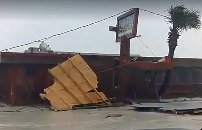
Friday, Oct. 7, 1:22 p.m.–Peak storm activity was approaching Flagler Beach and Palm Coast as the eye of Hurricane Matthew, churning at 120 mph (Category 3), was now nearly parallel with the Flagler coast. Numerous residents are reporting down trees, power lines, damages to homes such as ripped lanais and, on the Barrier Island, more severe damage to buildings, including a favorite: Snack Jack’s Restaurant, which had been severely damaged ahead of peak activity.
By 12:15 p.m. Florida Power and Light was reporting power losses to 50,150 customers in Flagler County, or two-thirds of all residents. Yet some residents in the W Section were reporting power back on, or at least power being intermittent. FPL crews are not out in Flagler County right now.
Rainfall for today was estimated at 8 inches.
“Peak winds 70 to 75 mph, that’s Flagler County average,” Emergency Services Director Steve Garten said. “Winds at the ocean would be greater, so we’re expecting more damage areas around the beach side.”
“At this point it’s the time to stay in place, shelter in place,” he said. There will be no emergency services if you need them.
Three shelters were open, with the shelter at Bunnell Elementary at capacity, with 700 people, and the shelter at Buddy Taylor Middle School with plenty of room, with 630 people there now. Rymfire Elementary, the shelter for people with special needs, still had room, with 323 people registered there. While this is not the time to move to a shelter, no shelter will deny you entry should you show up there.
Here is the 1 p.m. update from the Jacksonville National Weather Service Station, which has revised severity levels somewhat downward since 11 a.m. even as storm srge flooding is occurring, with large waves, and gusts of up to 86 mph are being reported in Flagler Beach–still well below what was feared. Ongoing neighborhood-by-neighborhood reports below.
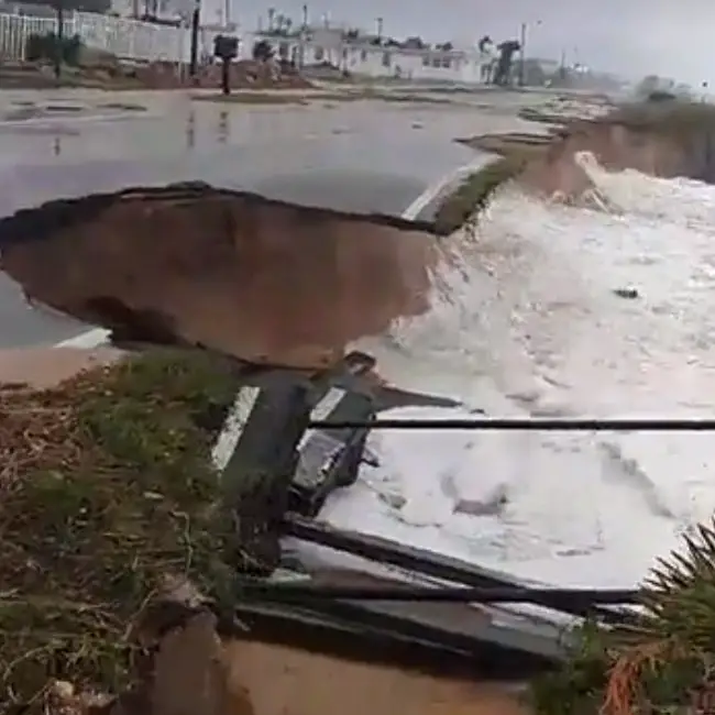
Storm surge flooding, beach erosion and infrastructure damage will continue for coastal areas today into tonight.
*Major Hurricane winds will remain well offshore east of the center with strong tropical storm force to hurricane force sustained winds impinging on our coast. Northeasterly winds are still pushing water towards our beaches. Worst Case Storm tide flooding possibilities…
*6 feet Above Ground Level (AGL) is still possible along the oceanfront,
*4 feet AGL rivers, estuaries and the Intra-coastal Waterway near the ocean,
*3 feet AGL in areas away from the ocean,
*St Johns River near Downtown up to 3 feet AGL
*Creeks and large lakes (Such as Crescent Lake) along the St Johns River south of NAS Jacksonville 3 to 4 feet AGL with record flooding likely for that area possible!
*Breakers of 10 to 15 feet will batter beaches. With major to severe beach erosion possible.
*Waves of 2 to 3 feet on the St Johns River and other large rivers may damage docks and moored boats.
*Waves will break through weak points in the dunes with water washing inland.
*Some damage to coastal infrastructure is possible, including damage to roads and vulnerable structures.
*8 to 12 inch rainfall in coastal counties could cause flash flooding in coastal areas, Clay and Putnam Counties
![]()
Friday, 8:45 a.m.–It may not seem that way to Palm Coast and Flagler County residents who have been losing power neighborhood by neighborhood since late Thursday night, but National Weather Service officials are now calling themselves “cautiously optimistic” as “the scenarios for a major hurricane landfall and devastating storm surge that we were looking at yesterday with a category 3/4 hurricane right on our coast, are not there.” (See the full weather briefing below.)
There will still be a storm surge and strong winds, but the feared worst may not happen anymore, unless Hurricane Matthew opts, as it very well could, to sling back west.
“That said,” the National Weather Service’s early-morning statement went, “significant storm surge flooding, beach erosion and coastal damage are still possible. Direct observations by buoys off the central Florida coast indicate the deep water waves are about 25 to 35 feet, that greatly reduces the size and impact of the breakers we will actually see. The duration of the storm will be reduced to 15 to 20 hours along the coast which also will help to reduce the coastal impacts. Overall we may see significant damage to the lowest and most exposed areas of the coast but overall the impacts should be MUCH lower than possible last evening.”
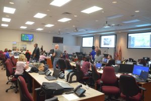
But starting in the R and W Sections last night in Palm Coast and now extending to numerous other neighborhoods in Palm Coast and beyond, as of 8 this morning, 14,800 customers had lost power in Flagler, representing about a quarter of all households, with losses piling up quickly.
So don’t be celebrating yet: winds in Palm Coast and the coast have reached 45 mph this morning, grounding all emergency personnel, “which means fire rescue and law enforcement officers are unable to respond to calls for service due to unsafe weather conditions,” said Steve Garten, Flagler County public safety emergency manager. “It is very important that everyone stays indoors from here on out.”
Crews will assess the storm damage, power outages and road closures, and first responders will get to those in need of services as soon as possible.
The Latest Weather Briefing from the National Weather Service-Jacksonville:
Click to access nws-jax-briefing-4.pdf
![]()
Late Night Matthew Track Change Hints at Slight Wobble East, But Shore Still Under Major Threat From Cat 4 Storm
Oct. 6, 11:05 p.m.–The latest track update from the National Hurricane Center brought a hint of relatively better news as Hurricane Matthew appeared to be nudging back off the coast of Flagler and Northeast Florida, providing just enough distance to lessen, at least slightly, the risks of a catastrophic strike and reduce the storm surge at least a little.
It was the first more hopeful trend line in the storm’s track in 48 hours. If it persists, the storm could yet push off toward the east a bit more, thus further relieving fears and pressure on residents and responders alike in the Flagler region. But this storm has been temperamental, alternately and unpredictably nudging east and west: that’s why the National Hurricane Center calls that while halo around the storm a cone of uncertainty.
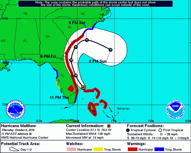
Two more predictive reports are expected overnight: forecasters will keep their fingers crossed and hope for a further push east. The storm’s push is the result of a troth coming from the Great Lakes. The push was expected, but its timing was uncertain, as is its durability.
For the latest, ongoing Hurricane Matthew coverage, go here.
“Catastrophic Damage” Anticipated In Flagler Beach, Curfew In Effect, Pier Already Damaged as Matthew Nears Coast as Cat 4
Oct. 6, 9 p.m.–Like a sentinel on point for the rest of the county–and like the iconic landmark it’s been for generations–the Flagler Beach Pier Thursday evening was the first victim to sustain damage from Hurricane Matthew, with far more damage, if not obliteration, expected in the hours ahead.
“I was told that it is leaning at the end on the north side,” Flagler Beach Manager Larry Newsom said this evening, just before 9 p.m. “As far as the actual damage I’m not sure. I’d be surprised that we don’t lose some of that pier based on the intensity of the storm, because it’s a wood pier, not concrete.”
Some residents were reporting wooden debris by (and from) the pier. For now, a leaning pier and wooden debris was a small price to pay relative to the storm’s grim toll in Haiti, where officials were placing the death toll at nearly 300 people Thursday evening–a stark warning for Barrier Island residents who have insisted, unwisely and recklessly, on staying put.
Newsom said about 80 percent of the residents of Flagler Beach had heeded the evacuation order. He was hoping for more. “I think a lot of them, if they’re looking at the weather report the same way the EOC is looking at it,” he said, referring to the Emergency Operations Center, “I have a feeling the number is going to go higher. The EOC staff and the commissioners have done a great job preaching the intensity of this storm.”
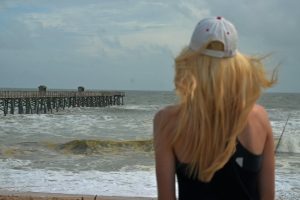
Florida Power and Light is also at EOC. Residents can follow and report outages at fplmaps.com: in fact, the first power outages of the storm started getting reported after 10 p.m. in the R and W Sections, with Matthew’s first major outer bands of rain beginning to lash the region and winds picking up to around 30 mph, from the northeast. Barometric pressure was dropping.
A curfew is in effect in Flagler County for all areas east of I-95, including all of Flagler Beach, Beverly Beach, Marineland, and portions of Palm Coast, from 7 p.m. tonight, and will remain in effect until 7 a.m., says Steve Garten, Flagler County’s emergency services manager. The curfew will be in place nightly as long as Flagler is in a state of emergency, in response to Hurricane Matthew, in order to control looting and other crimes.
The curfew declaration was approved by the county commission. The curfew includes a ban on alcohol sales, and forbids loitering or unjustified travel. Law enforcement will have the authority to charge violators with a misdemeanor.
“You need to be and get to where you intend to be by 7 o’clock tonight,” Garten said.
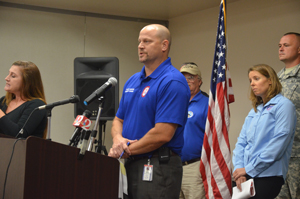
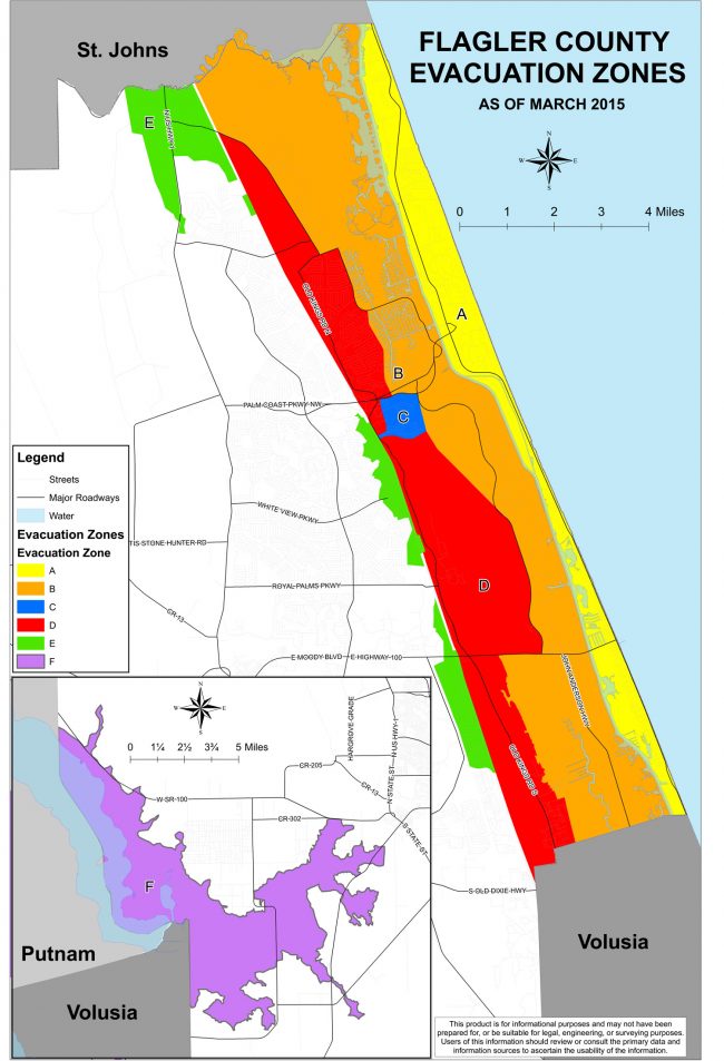
Of more concern to authorities is the continuing and mounting catastrophic danger posed by Hurricane Matthew, now expected to be a Category 4 or Category 5 hurricane when it strikes Flagler Beach Friday. Four zones in the county are under mandatory evacuation orders, including the entirety of the Barrier Island, which is expected to be struck by the most severe hurricane in more than a century.
“I hope my weather forecasts are dead wrong,” Bob Pickering, Flagler County Emergency’s famed weather specialist, said in a Facebook post late Thursday evening, in a tone reflecting his and his colleagues’ reluctant resignation to expecting–not just preparing for–the worst.
Though they are reluctant to say so too openly, officials are concerned that Flagler Beach and other communities along the Barrier Island may be leveled by an enormous storm surge, which will be topped by waves reaching from 15 to 22 feet, according to Garten: that’s enough to wash over the entire Barrier Island, into the Intracoastal, and up into the canal zone in Palm Coast. There are fears that water may reach as far east as I-95.
“The Barrier Island need to be evacuated period, period, period,” Garten said. “You have to heed the warning.”
But time was running out even for evacuations. The Flagler Beach bridge was due to be closed entirely to traffic at midnight tonight. The recommendations from officials is to travel west, not north, as roads north of Palm Coast are clogged with traffic. The west coast of Florida is opening shelters for east-coast refugees.
Asked explicitly whether Flagler Beach is at risk of being leveled, Garten drew on his experience during Hurricane Katrina, in 2005. “It leveled New Orleans where I was at, and I mean that, it moved houses,” Garten said. “People that did not heed the warnings ended up being casualties. So yes, certain areas and certain buildings will certainly be leveled.”
The Flagler County Sheriff has activated about 45 deputies per shift, up from what would normally be 16.
Thursday evening, residents in Palm Coast’s C Section were reporting high water: one resident’s dock was under water at high tide, with water just over the top of the seawall. The water retreated some, then rose again, and tonight was a few inches from overtopping the dock. At the old Yacht Club, the water had reached the seawall in late afternoon.
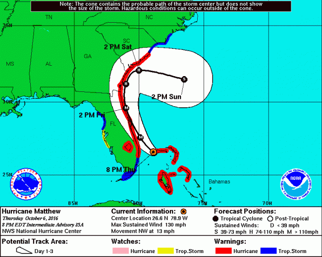
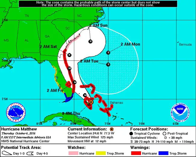
The 8 p.m. update from the National Hurricane Center brought no solace: the storm is, if anything, aligning even more cynically along the Florida shore in Flagler and St. Johns counties, as if intent on tracing a line where the Barrier Island meets the sea. The slow-moving storm would, at that pace and trajectory, result in maximum damage along the way.
That means given the current track, almost all of Flagler County, and certainly all of Palm Coast, will experience hurricane-force winds absent substantial weakening of the storm by the time it reaches Flagler Beach Friday in late morning.
One silver lining: After 24 hours, meaning around 8 or 9 p.m. Friday, the combination
of land interaction and a significant increase in the shear should cause weakening. But by then Matthew may have been finished wrecking Flagler’s coast, and the weakening of the storm would mostly benefit St. Johns and Duval counties. It would be too late for Flagler Beach, Beverly Beach and the Hammock, and big parts of Palm Coast.
Expect Matthew to reach its peak intensity in Flagler at 2 p.m. Friday.
Here’s the National Weather Service-Jacksonville’s 6 p.m. webinar briefing in full:
On a side note, Gov. Rick Scott rejected a call from Democratic Presidential candidate Hillary Clinton’s campaign to extend the state’s voter registration deadline as Florida officials turn their attention to the pending impact of the slow-moving “monster” Hurricane Matthew, the News Service of Florida reports tonight.
Speaking to reporters Thursday night at the state’s Emergency Operations Center, Scott said he’s not going to extend the deadline. “Everybody has had a lot of time to register,” Scott said. “On top of that, we’ve got lots of opportunities to vote. Early voting, absentee voting and Election Day. So I don’t intend to make a lot of changes.” The last day to register for the Nov. 8 election is Tuesday.
According to reports, Clinton’s campaign manager, Robby Mook, told reporters in a conference call on Thursday that the state should extend registration. “We’re hoping and expecting that officials in Florida are adapting deadlines to account for the storm,” Mook said. Voting in Florida is already underway through vote-by-mail ballots.
President Barack Obama signed an order Thursday to coordinate supplies and equipment for Florida in advance of Hurricane Matthew. Gov. Rick Scott, who requested the pre-storm relief, including water, food and tarps, said after the order was signed that Florida will need more federal aid.
![]()
Oct. 6, 3:30 p.m.–Flagler County Emergency Services is conducting a news conference at 3:30 p.m. The main points appear below the WNZF-provided video:
The main points:
Access to the Barrier Island will start being controlled as of 5 p.m.: only local residents of the island will be given access.
Steve Garten, emergency services director: “I cannot say this enough, you have to heed these warnings,” he said, citing his experience with Hurricane Katrina, and urging residents to evacuate west. Any shift in the storm track, west or east, will substantially change the effects on the ground–for the worse if it moves west, for the better, only slightly, if it moves east.
The news conference featured comments by County Commissioner Nate McLaughlin and Sheriff Jim Manfre, but their comments were mostly designed as additional sound bytes and warnings to residents to evacuate rather than substantially new information about the storm. The sheriff warned against complacency. “This is the one, guys,” Manfre said, recommending calls to the hotline number rather than the communication center.
Superintendent Jacob Oliva spoke about the shelter situation, with two shelters opened this morning, and an additional one at 1 p.m. Expect electricity when you get to the shelter: “You’ll be in good hands,” Oliva said, along with breakfast, lunch and dinner, with comfort stations (coffee, snacks). But bring your own pillows and blankets. The shelters are not full.
Representing Palm Coast, Fire Chief Mike Beadle again reiterated the evacuation recommendations. “We just cannot put our people in jeopardy,” he said, once winds go beyond 45 mph. “If you’re planning on leaving, you need to leave.”
“Picture a 500-mile wide freight train off its tracks. It’s coming,” Flagler Beach Police Chief said, describing Matthew. “If you don’t go to the west coast, at least go to a shelter.”
Mayor Catherine Robinson of Bunnell spoke of the many elderly residents in her town who have “no excuse for staying home,” and who should move to the shelter at Bunnell Elementary. “This is not a wolf event. This is the real deal.”
“Palm Coast has been a rapidly developing community, with better building codes,” County Administrator Craig Coffey said of the majority of Palm Coast neighborhoods west of I-95, where damage is expected to be of a lesser magnitude, but only in comparison with the catastrophic damage expected on the barrier island. “We do have a lot of facilities that have been built more to modern codes. That doesn’t make them invincible, but it’ll help mitigate the effects of the storm,” Coffey said.
![]()
The latest alert about Hurricane Matthew from the National Weather Service and the National Hurricane Center sums up the danger ahead. Here it is, word for word. These are not our words, but theirs:
* Major Hurricane Matthew is still expected to move DANGEROUSLY CLOSE the Florida First Coast and Southeast Georgia Coast Friday through Friday night into Saturday with catastrophic impacts expected along and near the coast.
* A major hurricane has not impacted this area in 118 years, since October 2nd 1898. There is NO local living memory of the potential of this event. If a direct landfall occurs this will be unlike any hurricane in the modern era.
* The western eyewall is expected to move along a portions of the coast with sustained winds 115 to 125 mph and gusts in the most affected areas!
* Winds will be higher in high rise structures in Downtown Florida [sic.] possibly strong Category 4 to Category 5 intensity!
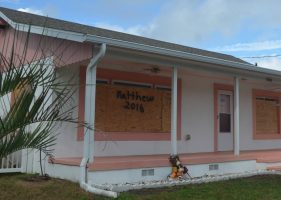
* Some of the lowest barrier islands will be completely overtopped with large battering wave and life threatening flooding. Barrier islands are likely to breached and it is extremely possible that new inlets will be cut in the worst affected areas.
* Please, Please heed the advice of public and emergency management officials. 40 people in New York and New Jersey did not heed these warning during Sandy and died in the storm surge! This will be a MUCH Greater surge than Sandy had along the New Jersey Shore!
Note: the Flagler Beach bridge will close to eastbound traffic at 4 p.m., except for residents of the Barrier Island. You must have ID. Wesbound lanes will not close at all even during the storm, though it is not recommended that you travel the bridge once winds hit 45 mph or above. Toll collection on the Hammock Dunes Bridge has been suspended.
“If you’re watching and in an evacuation area, get out. Don’t take a chance,” Scott said after a briefing at the state Emergency Operations Center in Tallahassee. “Time is running out. This is clearly going to have a direct hit or run right along our coast, and we’re going to have hurricane-force winds.”
Scott projected that millions of people will lose power for “days” from catastrophic winds and storm surge that he said “can completely wipe out well-built homes and destroy neighborhoods,” the News Service of Florida reported.
With 1.5 million people under evacuations, tolls have been lifted on most major routes out of southern and eastern Florida. Also, 2,500 members of the Florida National Guard have been deployed to three locations in the northern, central and southern regions of the state.
“Unfortunately, this is going to kill people,” said Scott, who planned to travel Thursday to the state’s East Coast, as he did on Wednesday. Scott said he intends to spend Thursday night at the Emergency Operations Center in Tallahassee.
Scott had planned a stop in Flagler, but subsequently cancelled.
Shelters: In response to heavy turnout to the two existing emergency shelter sites, Flagler County will open an additional general population emergency shelter at Buddy Taylor Middle School. The campus is located at 4500 Belle Terre Parkway, Palm Coast. The shelter will open at 1:00 p.m. Pets are not allowed at this shelter.
Here are the open shelters as of Thursday afternoon:
- Rymfire Elementary, located at 1425 Rymfire Drive, Palm Coast, will accommodate those with special needs – people who require assistance with daily living or who have medical conditions that prevent or hinder their ability to care for themselves, as well as those who require electricity for oxygen. A family member or caregiver should stay at the shelter with the individual. This shelter may accommodate up to 500 people with special needs.
- Bunnell Elementary, 305 N. Palmetto Street, Bunnell, will accommodate other residents who have no other place to go. Pets – dogs, cats, birds, rabbits, rodents and turtles – are the allowed pets. There is a four-pet maximum. Pet owners should bring current vaccination records and supplies, including crates and medications. This shelter may accommodate up to 4,000 people.
- Buddy Taylor Middle School. The campus is located at 4500 Belle Terre Parkway, Palm Coast. The shelter Pets are not allowed at this shelter.More shelters will open as needed.
- Questions? Call Flagler County Emergency Operations, 386/586-5111, but that’s for Flagler residents and business owners only..
![]()
Hurricane Matthew’s Threatening Track Refuses to Budge, Florida Hospital Evacuates as Do Swaths of Palm Coast and Flagler Beach
Oct. 6, 8 a.m.–The closer Hurricane Matthew approaches to Flagler County, the more its predicted path’s cone of uncertainty diminishes: Thursday morning, a few hours ahead of the first major winds from the storm, residents awoke to a storm track still stubbornly intent on close-shaving the Florida Coast all the way up to Flagler, only then beginning to make a slight turn toward the east and the sea.
The storm itself was strengthening again toward a Category 4 hurricane, making it the most dangerous storm to head for threaten Flagler in at least a generation. There is no cone of uncertainty about the damage and the danger ahead: both will be severe, which is why you’ll hear officials and media implore you in the next 24 hours to heed recommendations–and commands–to evacuate and head west, if you’re in evacuation zones, or to be prepared if you have opted to stay. The next 48 hours will not be forgiving.
Gov. Rick Scott had made tentative plans to visit Flagler at the Emergency Operations Center this morning. The plan was pushed back to an afternoon visit, then scrubbed, with Scott now planning to visit after the storm, County Administrator Craig Coffey said.
Flagler County, including Flagler Beach and Palm Coast, are now under hurricane warning. Last night’s forecasts compelled Florida Hospital Flagler to evacuate all its patients to other facilities. Mandatory evacuations of the Barrier Island, including Flagler Beach, the Hammock, Beverly Beach and Marineland, began at 6 a.m.
The Flagler Beach Bridge remains open in both directions, though at some point later today the sheriff’s office expects to block access except for residents, and later today, when winds reach 45 mph and beyond, as they are expected to, the bridge will close to traffic entirely, and emergency responders will not cross it.
A mandatory evacuation does not mean that you are forced to leave, or that cops will knock on your door, or that you may not exit your house. It means you will not get emergency or other government services should you need them: a tree falls on your house, a fire breaks out, a health emergency develops, and most likely you’re on your own.
As of 8 a.m., Hurricane Matthew had regained the strength it had lost over the Bahamas, churning at 125 mph and moving north-northwest at 12 mph. The National Hurricane Center’s description is grim: “Environmental conditions appear favorable for continued strengthening today and Matthew is expected to become an extremely dangerous category 4 hurricane while it moves over the northwestern Bahamas and approaches the east coast of Florida. After 24 hours, land interaction is likely to cause some weakening, and later in the period increasing shear should cause a more rapid decrease in winds.”
For Flagler County, the only hope is a very distant one: a broad weather trough approaching the Great Lakes region that begins to have a pushing effect on Matthew in 48 hours, then passes over Matthew in 72 hours, forcing it to turn decisively east, into the Atlantic. But that climatic cavalry may come too late for Flagler County, as that turn would happen right after the storm will have lashed the coast here: even without making landfall, its 40 to 45-mile span of hurricane-force winds means that its most savagely destructive zone will be wide enough to extend well inland into Palm Coast. And because of a storm’s uncertain path, it is also possible that Matthew wobbles inland, broadening its damaging path.
In the hunt for silver linings, there was a slight one this morning in Matthew’s path over the Florida coast further south. That path would mean the storm will have weakened from its Category 4 conditions at landfall further south, possibly reducing it to a Category 3 or less when it reaches Flagler, depending on its position over land (where it gets weaker) or water.
“On the forecast track,” the National Weather Service posted this morning, “the eye of Matthew should pass near Andros Island and New Providence in the northwestern Bahamas during the next few hours, pass near Grand Bahama Island late today, and move very close to the east coast of the Florida peninsula tonight through Friday night.” It is expected in Flagler at its severest Friday afternoon, though tropical-storm winds are expected starting late tonight or tomorrow morning.
The previous progression of storm stories is below.
![]()
Mandatory Evacuation Ordered for Palm Coast’s C and F Sections, Grand Haven and Barrier Island as Hurricane Matthew Surges
Oct. 5, 8 p.m.–The track of Hurricane Matthew released at 5 p.m. places the storm’s eye near the Flagler County shore between 2 and 4 p.m. Friday. “It now puts us at a higher risk of experiencing a direct hit,” Bob Pickering, Flagler County Emergency’s weather specialist, said this afternoon.
That prompted a mandatory evacuation starting at 6 a.m. for the entirety of the Barrier Islands and much of the areas between the Intracoastal Waterway and I-95, including the entirety of Palm Coast’s C Section and all the neighborhoods of the F Section east of Florida Park Drive and east of Palm Harbor Parkway. This zone also includes the area east of Old Kings Road, south of State Road 100 including Bulow and its adjacent neighborhood, Grand Haven and western Flagler Beach, and all the neighborhoods along Colbert Lane.
“The current storm surge estimates have risen and that will likely cause a greater impact to Flagler County,” said Steve Garten, public safety emergency manager in a release issued at 7:20 p.m. “We would like residents to head west. Shelter space is intended for those who have no other option so if you have friends and family you can stay with, please make those arrangements.”
What does “mandatory” mean? It does not mean that cops will be knocking at your door, forcing you to leave. It does not mean that cops will be preventing you from driving in and out of the neighborhood Thursday, or even crossing the Flagler Beach bridge. What it does mean is that if you have a medical or police emergency, you may not get a response. In other words, you may choose to hunker down in your house, but at your own risks. It would be as if you chose to swim in a surf rife with rip currents, without a life guard: you’re on your own if something goes wrong.
“We can’t actually make anybody leave, but after we put the mandatory evacuation in effect, and that especially applies to the area in the barrier island, people are not guaranteed a response if they call 911,” a county spokesperson said.
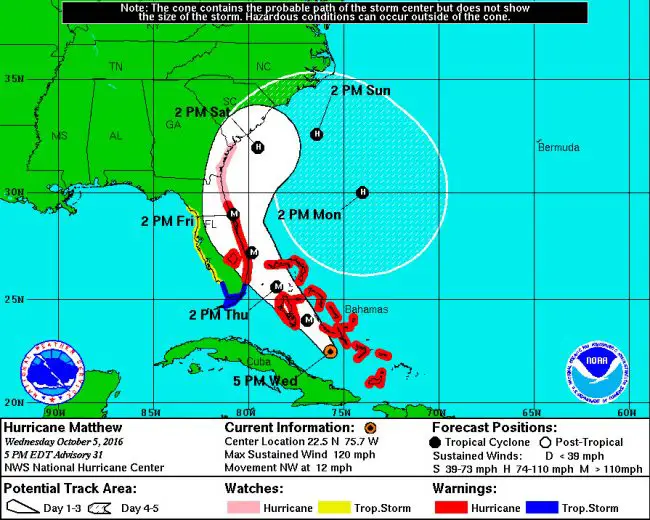
The now-Category 3 storm is still expected to wobble one way or the other, as it has with every recalculation of its track over the past three days. But the current track was bound to further increase the likelihood that local officials would declare a mandatory evacuation of the parts of the county nearest to shore, from the Barrier Island to I-95–as in fact they did early this evening. Larry Newsom, city manager of Flagler Beach, said that mandatory evacuation had previously been considered to start roughly at 8 a.m. Thursday.
The mandatory evacuation order also applies to the Woodlands, Hidden Lakes and the Toscana subdivisions due to the close proximity to Graham Swamp.
The latest storm tracks–especially with the uncertainty of its cone–make that a stronger possibility, with shelters being readied for local residents in some schools. The track has Matthew shearing the Florida coast slowly from about the level of Lake Okeechobee north, starting early Friday.
The track released at 7 p.m. points to one, very small glimmer of hope for Flagler: the storm may begin its swing back out to sea just south of Flagler Beach. That would not spare the Barrier Island very damaging winds and a storm surge, but it would spare it the effects of a direct hit, which would make a difference–and make a larger difference, for the better, for areas further west. If, in other words, the storm takes the coastline as its furthest point of advance, then damage could end up being limited proportionatelty.
But expect the miserable weather to start Thursday as winds will begin to whip up in the afternoon in the 20 to 30 mph range and tropical storm conditions develop overnight, with northeast winds at 35 to 50 mph, and increasing to 50 to 70 mph into Friday morning. About 1 to 2 inches of rain are expected overnight Thursday, with more Friday. As matters stand today, winds are expected to increase in Palm Coast to up to 90 mph Friday, with 3 to 5 inches of rain, possibly more in places.
This evening, the eye of Hurricane Matthew was moving northwest at around 12 mph, preparing to cross the Bahamas tonight and tomorrow, getting very near the east coast of Florida by Thursday night. “Some strengthening is forecast during the next couple of days, and Matthew is expected to remain at category 3 or stronger while it moves through the Bahamas and approaches the east coast of Florida,” the National Hurricane Center’s 5 p.m. bulletin states.
Hurricane-force winds extend outward up to 45 miles from the center and tropical-storm-force winds extend outward up to 175 miles. That means that whether the eye is at or within 45 miles of shore, the effects on shore would still be those of a hurricane.
Equally worrisome to local residents and officials is the storm surge, which would swell higher if it coincides with high tide. Friday’s high tide is at 6:20 p.m.: that’s about the time when the storm would be above or near Flagler. “That’s not good,” Pickering said.
Two shelters will open Thursday morning: Rymfire Elementary (1425 Rymfire Drive in Palm Coast) will open at 6 a.m. for special needs only–-people who require assistance with daily living or who have medical conditions that prevent or hinder their ability to care for themselves, as well as those who require electricity for oxygen. A family member or caregiver should stay at the shelter with the individual.
Bunnell Elementary (305 N. Palmetto Street, Bunnell), will open for the general public and for people with pets. Only dogs, cats, birds, rabbits, rodents and turtles are the allowed pets. No elephants, please. There is a four-pet maximum per family. Pet owners should bring current vaccination records and supplies, including crates and medications.
More shelters may be opened, depending on the extent to which they fill up. “Shelters are designed to be for a last resort,”a county spokesperson said. Sleeping bags, pillows and blankets should be among those personal items, as cots are available in limited numbers. Air mattresses are not permitted.
See the latest storm briefing from the National Weather Service below, as of Wednesday morning, and previous developments below that.
Click to access nws-jax-briefing-oct-5-7-p.m.pdf
Wednesday morning briefing.
Tuesday evening briefing
Monday briefing.
![]()
Mandatory Evacuation of Barrier Island and Flagler Beach Set for Thursday, Schools Closed Thursday and Friday as Hurricane Matthew Nears
Oct. 5, 3 p.m.–A mandatory evacuation order for the entire zone east of the Intracoastal Waterway in Flagler County will go in effect Thursday, though the time (previously noted as 8 a.m. by Flagler Beach Mayor Linda Provencher) has not officially been set yet. The order will affect Flagler Beach, the Hammock, Beverly Beach and Marineland.
For now, Flagler County officials are calling for voluntary evacuations of the entire Barrier Island as well as the voluntary evacuation of areas along the Intracoastal Waterway and along Palm Coast’s canal system, all of which are vulnerable to an expected storm surge from Hurricane Matthew Friday and Saturday. Residents of mobile, modular or manufactured homes in the area are also asked to voluntarily evacuate. The county had earlier put out a call for all mobile homes in the county to be voluntarily evacuated, but that was rescinded. Mobile homes on the west side of the county so far are not affected.
The voluntary evacuation call will become a mandatory evacuation order on Thursday, says Julie Murphy, the spokesperson for Flagler County government. The call for voluntary evacuations was issued late this morning. (Brevard County issued a mandatory evacuation order for its barrier island residents effective today at 3 p.m. A mandatory evacuation order is also in place starting at 3 p.m. today for the entirety of low-lying Beaufort County at the southeastern tip of South Carolina.)
The National Hurricane Center’s 2 p.m. update on Hurricane Matthew did not substantially change the storm’s ominous track other than to add one more element of concern: the storm now appears to be rounding a broad northeasterly loop, once it travels past parallel the Florida-Georgia border, with some models showing the storm possibly looping far enough back to the Florida peninsula. But those are still distant and very speculative models. Half the loop, however, is not as speculative: it is being created by the action of a high pressure system bearing down from the north, and essentially forcing the storm to whirl back.
The Flagler County Sheriff will close its administrative offices Thursday and Friday but will increase its cops’ ranks on patrol both days, to 40 cops per shift, a sheriff’s spokesman said. Gov. Rick Scott has activated 500 members of the Florida National Guard already, with 6,000 members ready to go on duty when necessary.
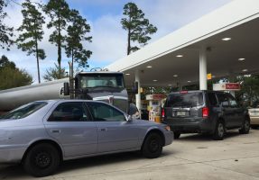
There have been spotty reports of fuel shortages, but those have been temporary and quickly resolved.
The storm surge from Hurricane Matthew is a critical problem, distinct from wind and rain damage, and would affect the region even if the hurricane stays offshore, which is what’s compelling officials to ask residents and businesses to take immediate precautions. That surge’s elevation will depend on tides, but current models have it surging anywhere from 1 to 3 feet, to, at worst, 8 to 12 feet, which would be cataclysmic for the storm-surge zone. It’s important to note that those are only projections for now: the only certainty is that there will be a storm surge and that it will be considerable.
The affected evacuation areas correspond to Areas A and B on the county’s evacuation map, which can be seen here, where you can input your address to check your location, or here for a more general map.
The 11 a.m. update from the National Hurricane Center showed Hurricane Matthew getting closer to the Florida coast, with growing likelihood of landfalls along the coast from Cape Canaveral to Volusia and Flagler counties. Matthew is still expected to be a major hurricane as it shears into the Florida coast Friday morning.
“The environment between the Bahamas and Florida is favorable for Matthew to restrengthen some during the next couple of days,” the National Hurricane Center stated at 11 a.m. “After that time, the shear is forecast to increase, resulting in gradual weakening.” That means that it would have begun weakening by the time it approaches Flagler, but weakening is a relative term: even if it nears Flagler as a Category 2 hurricane, its impact would still be severe, as would its storm surge.
“The one key point and this is a very critical, key point, is that the focus should be on the cone of error, the tropical cyclone could go anywhere within the cone of error,” Bob Pickering, the county’s weather specialist, said just before 11 this morning. That cone of error now has Flagler County very much within it.
The storm is not predicted to be a massive rain-maker: rainfall locally is expected to be from 4 to 7 inches, with possibly higher localized amounts.
Meanwhile, the Flagler County Emergency Operations Center has extended the call in center hours until 8 p.m. Wednesday. “A team of volunteers manned the phones yesterday afternoon and continue to do so today,” said Steve Garten, public safety emergency manager. The call in number is 386/586-5111. Calls will be answered beginning at 8 a.m. Thursday and continuing 24 hours a day until the storm passes.
Hurricane Matthew is responsible for the death of at least 11 people so far in Haiti and Cuba. The toll is expected to rise.
![]()
Schools Closed Thursday and Friday as Hurricane Matthew Tracks Double-Edged Sword of Uncertainty
Oct. 5, 9 a.m.–Hurricane Matthew showed barely perceptible signs of changing course or diminishing in force Tuesday as officials prepared for what potentially could be the most serious hurricane to threatening the coast of Florida since Floyd in 1999, and for storm-surge flooding that could inundate coastal areas by 3 feet or more. “Given the incremental westward trend in the model data, the expected impacts continue to amplify, and perhaps even become devastating,” the National Weather Service warned.
By Wednesday morning, while the storm track was still unchanged relative to Florida–and indeed may have worsened for South Florida, where Matthew may see landfall–there was the smallest glimmer of hope that, given its extended track, the possibility of landfall in the Flagler region, while still present, could diminish slightly.
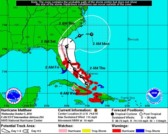
At 8 a.m. Wednesday, the latest storm track from the National Weather Service and the National Hurricane Center showed Matthew still traveling north in a line closely paralleling if not shaving the Florida shore. Hurricane warnings have been issued for south Florida from North of Golden Beach to Sebastian Inlet and around Lake Okeechobee. Hurricane watches have been issued for the entire coast north of Sebastian Inlet to the Fernandina Beach, including for all of Flagler County’s coast, and tropical storm warnings are in effect for the southern tip of the state.
Watches for Flagler are expected to turn to warnings by Thursday or Friday, assuming Matthew continues on its current trajectory. There are now “increasing chances of hurricane force winds over coastal areas of northeast Florida into some interior portions along the St. Johns River Basin, and over the adjacent coastal waters due to the proximity of the system near the coast,” the National Weather Service predicts. “Tropical force winds are anticipated in some inland locations between U.S. 301 and Interstate 75.”
But the storm, just clearing Cuba after making landfall on the eastern tip of Cuba early this evening, and wrecking that part of the country, is still far enough away that its cone of uncertainty is turning into a double-edged sword for communities two and three days north of its current path: it’s leaving officials trying to calibrate their caution with urgency but without overly alarming residents too soon. While inessential events, entertainments and community meetings have been cancelled Thursday and Friday, the Flagler County School District had refrained from announcing any school closures yet, that changed Wednesday morning.
Wednesday classes would go on as normal, but all after-school activities were cancelled for Wednesday (with the exception of extended day programs), and schools will be closed Thursday and Friday. “Flagler Schools is preparing to have a number of schools activated as emergency shelters as this very dangerous storm systems approaches the Flagler County coast,” the district said in a statement issued at 9 Wednesday morning. “We encourage everyone in the county to listen to our emergency managers and take the necessary safety precautions.”
Nevertheless Thursday now appears to be more normal than not, some rain aside: the storm has traveled more slowly than expected, and Wednesday morning Matthew was still traveling at just 10 mph in a north-northwest direction, with maximum sustained winds of 115 mph, weaker than on Tuesday. But it was expected to gain strength again as it barreled just west of the Bahamas. The slowness of the storm has pushed back its estimated arrival time in the Flagler region. It had been expected to hit the area Thursday night into Friday. It is now expected to have its maximum impact locally Friday morning, from around dawn, into the day Friday and Friday night. The problem, again, is Matthew’s painful slowness: even if it remains offshore, its vastness and slowness means that its damaging force of winds and rain will linger agonizingly before it moves away.
Flagler County declared a state of local emergency at noon Tuesday, but for now that’s mostly a formality. Local government agencies will prepare and be on heightened alert (see the details below from earlier stories), but the state of emergency does not translate to visible consequences until it starts affecting residents with evacuation orders or road and bridge-closings. Those possibilities are still only possibilities, and they’re a way off, if then.
Matthew’s closest approach to northeast Florida will likely be Friday. Between now and then, the track could change significantly enough to differ between an actual emergency locally, and one in name only. The problem is that no one, from experts at the National Hurricane Center to local emergency management or other government officials, can predict such changes. They can only analyze the actual storm track, run it through innumerable models, and make estimates about where the storm may head next. The estimates are accurate near the storm, but get progressively less accurate with distance ahead of the storm.
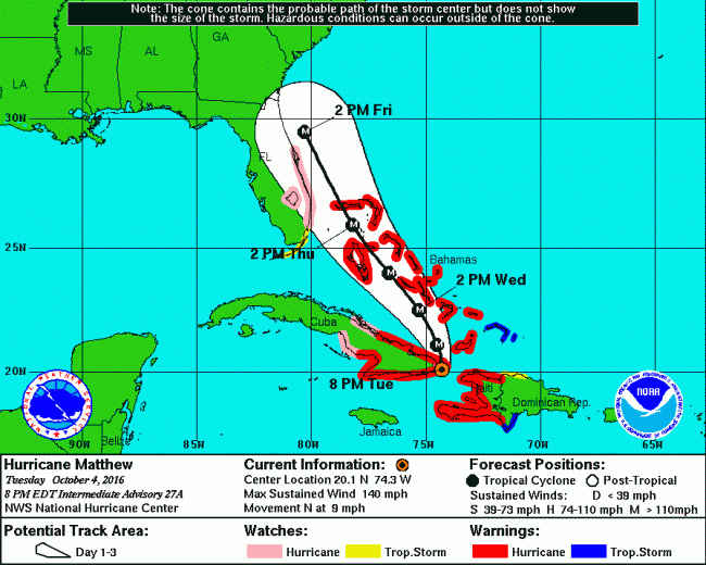
Based on weather forecasters’ normal error bracket in forecasting the storm’s current track, Matthew will be traveling close enough to the Northeast Florida shore, including Flagler County, that it could still make landfall in spots along the way, though that possibility diminished between Tuesday and Wednesday morning’s forecasts. Even if it doesn’t, the storm is powerful and wide enough that a significant zone extending from the eye would experience hurricane-force winds. Again, that’s based on its current track, which could change–for the worse, or for the better, depending on whether Matthew decides to shift east or west.
There was a note of hope for Flagler County and Northeast Florida in the 8 p.m. forecast: while the National Hurricane Center recognized “a stronger western Atlantic ridge than in previous runs,” accounting for Matthew’s dangerous shift east, toward shore (“necessitating the southward extension of the hurricane watch in Florida,” the hurricane center stated), that same Atlantic ridge, or weather system, is also “forecast to move eastward, allowing Matthew to turn northward and then northeastward.” That would happen in three days–right about the time when it would be bearing down on the Flagler region. In other words, the likelihood that it would begin shifting away from shore, after doing a sort of slow-motion sling-shot around this area, is growing. The question is whether it will execute that sling shot before or after it passes by the Flagler region. When all predictive science fails, keep your fingers crossed.
On its current track, life-threatening storm surge is still very possible along the shore. If the storm moves west, coastal flooding and heavy rainfall is likely. The storm could also move east, away from land: it’s early enough that that remains a possibility. Should that happen, wind, rain and flood damage would diminish proportionately, though tropical storm conditions would still be likely along the shore, as would be a storm surge and damaging erosion.
The hurricane center put it this way: “When a hurricane is forecast to take a track roughly parallel to a coastline, as Matthew is forecast to do from Florida through South Carolina, it becomes very difficult to estimate impacts this far in advance. For example, only a small deviation of the track to the left of the NHC forecast could bring the core of a major hurricane onshore, while a small deviation to the right could keep all of the hurricane-force winds offshore. It will likely take another day or so for the potential impacts of Matthew in the United States to clarify.”
Wednesday morning, Hurricane Matthew was moving north-northwest at about 10 mph, and had weakened to about 120 mph after hitting land, but is expected to strengthen again in open water and maintain Category 4 status for the next two days. The hurricane center concludes: “Matthew will be moving over sea surface temperatures of 29 to 30 degrees Celsius and the shear is expected to remain low during the next couple of days. These conditions should allow some
slight restrengthening while it moves through the Bahamas. Increasing shear later in the forecast period is likely to cause gradual weakening.”
That weakening could also be timed just right for when the storm arrives in the Flagler region, though the weakening will be relative:L it may no longer be a Category 4 hurricane by Friday at noon, but it will still be a very powerful, very wide hurricane.
The National Weather Service warns: “Preparations for the potential of a major hurricane passing near the northeast Florida and Southeast Georgia coastline should continue in earnest and with high urgency. Residents and visitors are reminded once again to maintain a high level of situational awareness for the next few days.”
![]()
Flagler and Palm Coast Officials Prepare to Declare Local Emergency as Hurricane Matthew Veers Closer; Cancellations Mount
Tuesday, Oct. 4, 3 p.m.—Flagler County and Palm Coast officials declared a local state of emergency at noon today, as Hurricane Matthew appears to be heading much closer to the county than previously forecast. The hurricane, a Category 4 storm, is expected to impact the region starting late Thursday into Friday.
“We’ve noticed the same wobble,” County Administrator Craig Coffey said of the storm’s westward shift in the past 12 hours. “We’re in full mode right now, we will be declaring today.” The order declaring a local emergency has already been drafted.
County Commission Chairman Barbara Revels said she expects to get a phone call from county emergency staff and the administration soon to get the order in place. Palm Coast Mayor Jon Netts said he would be at City Hall later this morning, around 9:30, with similar expectations. “You never know with the weather forecast but I would much rather be prepared than ill prepared,” Netts said.
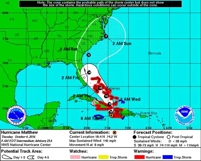
At 9:30 a.m., Revels said the state of emergency would go into effect at noon today.
As of 8 a.m., the National Hurricane Center was showing a track for Hurricane Matthew closely paralleling the Florida coast. “Direct hurricane impacts are possible in Florida later this week,” the hurricane center’s latest advisory stated. “Tropical storm and/or hurricane watches are likely later this morning for portions of the Florida peninsula and the Florida Keys.” Those watches and warnings would move up the coast ahead of the storm.
A local state of emergency will not immediately have any impacts on residents beyond heightening awareness and information campaigns urging residents to be well prepared. But Coffey said he’s already had discussions with School Superintendent Jacob Oliva about possibly shortening the school day Thursday and closing schools on Friday.
The health department has been put on notice to start shelter preparations for Thursday and Friday night, should they be needed. The county’s building and code enforcement departments are scouring properties to ensure that construction sites and residences have taken the necessary precautions against loose objects and debris. The county has some concerns about dune breaches in several spots in the Hammock, where seawater can penetrate and cause flooding issues because of the expected storm surge. The Flagler Beach Pier is expected top close during the storm, and if winds exceed 45 mpg, the Flagler Beach bridge will be closed to traffic.
“Everybody’s cranking up their efforts right now,” Revels said.
Of the storm itself, the National Hurricane Center had it between Cuba and Haiti this morning, creeping north slowly. “The satellite presentation of Matthew remains very impressive this morning. The eye was obscured during part of the night, but has become more distinct and slightly larger during the past couple of hours,” the center’s 8 a.m. briefing stated. “Matthew is likely to produce devastating impacts from storm surge, extreme winds, heavy rains, flash floods, and/or mudslides in portions of the watch and warning areas in Haiti, Cuba, and the Bahamas. Please consult statements from the meteorological services and other government officials in those countries.”
The fear is that of the storm track remains close to what it is, similar effects would be ahead for the region locally.
By 11 a.m., Flagler County Emergency was summing up the local situation this way: “Increasing chances of tropical storm force winds over Flagler County Florida, and a slightly increasing chances of hurricane force winds over the coastal locations and adjacent coastal waters.” The chance of Tropical Storm Force Winds is now 69 percent, up from 12 percent Monday morning. The chance of hurricane-force winds is at 14 percent for coastal areas.
Here’s a list of confirmed cancellations as of Wednesday. More are expected:
- Walmart in Palm Coast is closing at 5 p.m. Thursday and will remain closed until Saturday. The time of opening is yet to be determined.
- Hospitals: Florida Hospital Flagler’s outpatient facilities will close Thursday at 7 a.m. Additionally, all procedures, diagnostic testing and outpatient appointments are cancelled and will need to be rescheduled for future dates. Florida Hospital Oceanside in Ormond Beach and Florida Hospital New Smyrna in New Smyrna Beach have been evacuated. Emergency rooms will be open at Florida Hospital DeLand, Florida Hospital Fish Memorial in Orange City, and Florida Hospital Memorial Medical Center in Daytona Beach.
- Flagler County Schools will be closed Thursday and Friday (some of them will be prepared as shelters.) Classes will be held as scheduled on Wednesday, but all after-school activities Wednesday, including sports and music rehearsals, are cancelled.
- The Flagler County Courthouse, including all clerk of court and judicial activities, will be closed Thursday and Friday. However, First Appearance hearings will be conducted Thursday morning in all four counties. There will be no First Appearances on Friday. Weather and facilities permitting, First Appearances will resume on Saturday, Oct. 8 and normal courthouse operations will resume on Monday Oct. 10. During this emergency, all court deadlines will be extended and all scheduled court hearings will be rescheduled when court resumes.
- The Flagler County Supervisor of Elections office will close Thursday at noon and remain closed until Monday morning. Poll worker training classes have been canceled for Thursday and Friday. The Elections Office will be open for extended hours on October 11 to accept voter registration applications. Hours on Tuesday will be from 8 a.m. to 5 p.m. Again, the deadline to register to vote for this election is 5 p.m. on Tuesday, October 11, 2016.
- National Night Out, scheduled for Tuesday evening in Flagler Beach.
- Flagler County Citizens Academy, scheduled for 5 p.m. Thursday.
- Daytona State College will hold all its classes as scheduled only through Wednesday afternoon, cancelling them at 5 p.m. and beyond. (That’s a change in plan: the college had originally planned to hold classes tonight, but changed course in mid-afternoon and opted for closure.) All campuses, including the Palm Coast campus, but will close Thursday and Friday.
- Bethune-Cookman University has cancelled all classes past Wednesday at noon, and will be closed Thursday and Friday. Students are being evacuated. Those who must remain on campus will be provided shelter. For questions, call 386/866-274-0733 or 386/481-2900.
- Stetson University’s DeLand campus will cancel classes after noon Wednesday and close Thursday and Friday, Residence halls will close at noon Thursday. If students have no place to shelter, Stetson University will work with them to provide safe and appropriate accommodations. Students are asked to fill out an evacuation information form, available to all residential students through Housing Central, accessible through mystetson.com. Students are encouraged to check in with families and let them know their plans.
- Embry-Riddle Aeronautical University will close Thursday and remain closed Friday and Saturday. No scheduled evacuation of the campus at this time. Residence halls will remain staffed and open for resident students until further notice.
- Palm Coast City Hall, the Palm Coast Community Center and the Palm Coast Utility Office will be closed Friday, Oct. 7.
- Garbage collection in Palm Coast will remain on the normal schedule Thursday, but residents who are evacuating should not leave their trash cans out. For Friday, Oct. 7, garbage collection throughout Palm Coast is canceled. Residents who normally receive Friday collection should plan to put out their trash on the next regularly scheduled pickup day.
- All Palm Coast parks, including the Palm Harbor Golf Club, Frieda Zamba Swimming Pool and the Palm Coast Tennis Center, will be closed Thursday through Sunday, Oct. 9. All team practices and games at city parks, as well as the PDA Fall Classic soccer tournament, are canceled for Thursday through Sunday.
- All Homecoming activities (including Industry/Career Expo) scheduled at Embry-Riddle University on Thursday and Friday are canceled. Saturday homecoming events are still being evaluated.
- Access Flagler First, scheduled for Friday morning.
- First Fridays in Flagler Beach.
- Soda With a Cop, which had been scheduled for Friday at 4:30 p.m. at Chick-Fil-A in Palm Coast.
- Creekside Festival, the Flagler Chamber’s annual two-day event at Princess Place Preserve, which had been scheduled for Saturday and Sunday, Oct. 8 and 9.
- The Chamber’s Common Ground breakfast, scheduled for Oct. 6, which was to feature the county’s city managers.
- The planned K-9 fundraiser at the Beachfront Grille, which had been scheduled for Saturday.
- First Friday Garden Walk at Washington Oaks Gardens State Park, which had been scheduled for Friday at 10 a.m.
- Second Saturday Plant Sale and Herbs in the Garden, which had been scheduled for Saturday at 10 a.m. at Washington Oaks State Park.
- Castillo de San Marco National Park in St. Augustine is closed Thursday, Friday and Saturday.
- The Florida Agricultural Museum’s planned Pellicer Creek Civil War battle reenactment, scheduled for this weekend, is re-scheduled for Nov. 4 and 5.
- The third annual Pink Gala Flagler, a fund-raiser for breast-cancer awareness scheduled for Oct. 7 at the Hilton Garden Inn, in Palm Coast, was rescheduled to Oct. 21.
- Bingo at the VFW Post 8696, scheduled for Thursday evening, is cancelled.
![]()
Local governments are offering the following sandbag locations:
A self-service sand station and sandbags are available during daylight hours at:
- Palm Coast Public Works Yard, 1 Wellfield Grade, off U.S. 1 just north of Palm Coast Parkway, Palm Coast.
- Fire Station 71, 89 E. County Road 2006, western Flagler County.
- Fire Station 41, 5593 N. Oceanshore Boulevard, in the Hammock.
- Sand is on its way to Fire Station 92, at the Flagler Executive Airport, 201 Airport Road.
- Bunnell Fire Station 62, 1601 Old Moody Boulevard
- Flagler Beach Fire Station 1, 320 S. Flagler Avenue, in the front parking lot.
In addition, empty sandbags (but no sand) are available during regular business hours of 8 a.m. to 5 p.m. Monday through Friday at:
- Palm Coast Community Center, 305 Palm Coast Pkwy. NE, (corner of Palm Coast Parkway and Club House Drive), Palm Coast.
- Palm Coast City Hall, 160 Lake Ave., Palm Coast.
- Palm Coast Utility Department, 2 Utility Drive, Palm Coast.
Then, those empty sandbags can be filled at these two additional self-service sand stations:
- Indian Trails Sports Complex, 5455 Belle Terre Pkwy., Palm Coast
- Seminole Woods Neighborhood Park, 350 Sesame Blvd., Palm Coast
For more information, call Palm Coast Customer Service at 386-986-2360.
Other Media Coverage and Useful Sites:
National Hurricane Center
National Weather Service-Jacksonville Briefings
Flagler County Emergency
The Palm Coast Observer
The News-Journal (no paywall during the emergency)
WNZF Newsradio Live Stream
The Weather Channel
![]()
Hurricane Matthew Veering Closer to Flagler and Florida Coast In Latest Track
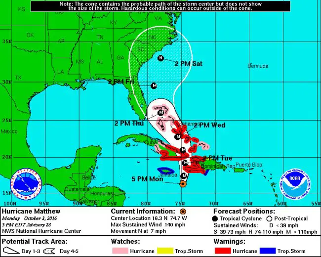
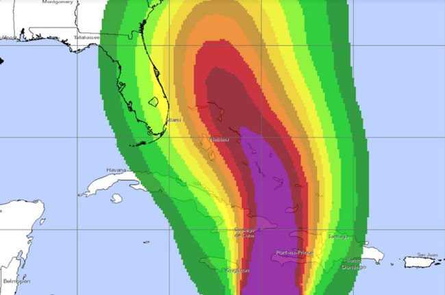
Monday, Oct. 3, 9 p.m.–Monday morning Hurricane Matthew looked poise to parallel the Florida coast, including Flagler, from a relatively safe distance far offshore. But in the National Hurricane Center’s latest track, released at 7 Monday evening, Matthew’s five-day forecast cone has taken a turn for the west, and now encompasses the entire eastern half of the state, including all of Volusia, Flagler and St. Johns counties.
In mid-afternoon, Gov. Rick Scott issued a state of emergency for the entire state, the second such declaration in four weeks: in early September, Hurricane Hermine, a Category 1 storm, triggered the emergency ahead of striking the panhandle just south of Tallahassee–and leaving big swaths of the state capital without power for days. Matthew is currently a Category 4 hurricane, stronger than any hurricane nearing Florida in 11 years.
Hurricane Matthew had been expected to weaken somewhat as it traveled north. The 7 p.m. forecast revealed more bad news: it is now expected to remain a “major” hurricane even as it nears Florida and moves north, weakening to a lesser hurricane only when it crosses past the Florida border.
For Flagler County, that still means, for now, more severe winds, damaging conditions along the shore, with a lot of erosion to the beaches, and more rain, but not yet hurricane conditions: the storm’s position at 8 p.m. Friday would be parallel with Flagler County, but still some 150 miles or more offshore. The fear is that current trends continue–that the storm would continue edging westward, closer to shore.
Still, the current forecast has increased the Flagler region’s chances of experiencing tropical storm conditions to about 40 percent, and 60 percent along the shore.
Monday morning’s story is below.
![]()
“Major” Hurricane Matthew Grazes at Edge of Concern for Flagler County
Monday, 2:30 p.m.–Hurricane Matthew will have an impact on Flagler County and the rest of coastal Florida by the end of the week, but that impact will be indirect and likely limited to bands of possibly severe rain and gusts of wind. Of more concern to the Barrier Island, the storm will likely cause damaging erosion to the beaches and dangerous rip currents in the surf. That’s assuming the current [path of the hurricane remains roughly within its projected cone as predicted by the National Hurricane Center in Miami.
If the hurricane path changes even slightly to the west, its impact on Flagler would become more serious, raising the possibility of tropical storm conditions. If it verges slightly east, the effects on the county would diminish substantially. The latest change between 8 a.m. and 11 a.m. (the last two forecasts by the National Hurricane Center) was somewhat worrisome: the storm edged a very little bit east, doubling the probability of tropical storm conditions for Flagler Beach from 14 percent in the earlier forecast to 28 percent in the 11 a.m. forecast. It was 5 percent Sunday. (See the latest, complete weather briefing below, from the National Weather Service in Jacksonville, and keep up with those briefings here.)
“The cone of uncertainty is still touching us, I’ve got the feeling that in a couple of days we’ll be out of that cone,” says Steve Garten, Flagler County’s emergency manager. But that would still result in windy conditions and a dangerous surf. “Look at the beach but do not go into the water,” he said, and rain bands could whip the county even if the storm moves east.
Garten briefed the Flagler County Commission on the storm this morning, reminding commissioners and the public that should sustained winds–not gusts–of 45 mph or higher strike Flagler Beach, the Flagler Beach bridge would be closed to traffic, and emergency vehicles, including ambulances, fire trucks and cops, will not cross the bridge even if people on the beach side are in distress. “We’re not going to risk first-responders” in such conditions, Garden said. But that possibility is remote, as the path of the storm appears for now.
At 11 this morning, Hurricane Matthew was considered a major hurricane, with maximum sustained winds of 140 mph, making it a Category 4 hurricane. The last Category 4 hurricane to strike Florida was Hurricane Charley in 2005, when it slammed into southwest Florida as the strongest storm since Hurricane Andrew in 1992. Hurricane Floyd in 1999 was also a Category 4 hurricane. It ever struck Florida, but like Matthew, it paralleled the coast enough that it caused severe erosion and shattered the end of the Jacksonville pier.
Hurricane Matthew is expected to weaken somewhat, losing its “major” denomination, once it crosses the Windward Passage between Cuba and Haiti Tuesday morning. It is expected to do so at a painfully slow speed for island dwellers on either side of the passage, where damage will be severe.
Late this morning the storm was 205 miles southeast of Kingston, the Jamaican capital, moving north at just 6 mph. Its current path, if sustained, will be very damaging to the Bahamas. The closest approach to Florida will be Friday or Saturday.
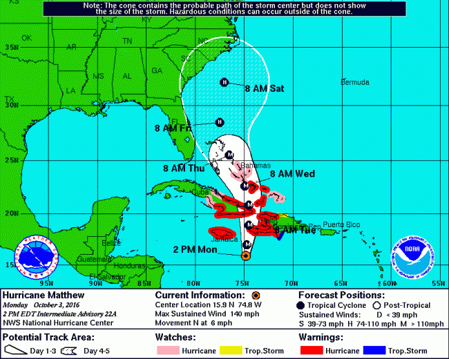
“Beach and oceanfront should prepare for the possibility of an extended duration high surf and beach erosion event,” Bob Pickering, Flagler Emergency’s weather specialist, said this morning. “People who live along the beach should be prepared for a long duration nor’eastern event with gale force winds. However it’s too early to speculate on other impacts,” including the extent of winds and flash flooding, which is possible even in the western, agrarian part of the county. “Intense rainfall is possible with this event. it’s just impossible to pinpoint where it’s going to happen,” Pickering said.
The path of the storm, he said, will be dictated by the interaction of its own force heading north and that of a high-pressure system bearing down from the north. Picture the high pressure system as a mountain, Pickering said, and the hurricane as a seeker of valleys around the high pressure system: the hurricane will travel along those valleys.
“We encourage everyone to continue to monitor the latest bulletins from us as well as from the national hurricane center and the national weather service,” Pickering said, especially if the storm takes a more westerly track. “A little bit of the nudge will increase the impact, but to what degree, we can’t really speculate on that.” At least not yet.
The county issued a few suggestions. At home preparations should include a pantry that is stocked with a week’s worth of non-perishable foods and juices; a gallon of water per person per day; a manual can opener and cooking foods and utensils; disposable plates and plasticware; medicines – including prescription drugs; flashlights and batteries; and, a manual or battery operated weather radio.
“Make sure those canned goods are things that you and your family will eat,” Garten said. “Have some comfort foods on hand too, especially if you have children. Don’t forget to have supplied for your pets, too.”
Reduce the risk of water entering the home by making sure that windows and doors have proper caulking and weather stripping. Package valuable documents such as: titles, deeds, insurance papers, bonds, in waterproof containers for safekeeping.
“It’s also a good idea to fill the tank of your car,” said County Administrator Craig Coffey. “Even if we aren’t hit hard, bad weather in other areas could slow the delivery of commodities like gasoline.”
Garten also recommends knowing if you live in an evacuation zone as determined from storm surge models provided by the National Oceanic and Atmospheric Administration. Go to flagleremergency.com for more information.
“The decision to evacuate a zone is based on the track and intensity of the specific storm,” Garten said. “We will make sure everyone knows if and when they need to evacuate.”
![]()
Weather Briefings from Jacksonville’s National Weather Service Station.
Click to access nws-jax-briefing-2.pdf
![]()
![]()
Local governments are offering the following sandbag locations:
A self-service sand station and sandbags are available during daylight hours at:
- Palm Coast Public Works Yard, 1 Wellfield Grade, off U.S. 1 just north of Palm Coast Parkway, Palm Coast.
- Fire Station 71, 89 E. County Road 2006, western Flagler County.
- Fire Station 41, 5593 N. Oceanshore Boulevard, in the Hammock.
- Sand is on its way to Fire Station 92, at the Flagler Executive Airport, 201 Airport Road.
- Bunnell Fire Station 62, 1601 Old Moody Boulevard
- Flagler Beach Fire Station 1, 320 S. Flagler Avenue, in the front parking lot.
In addition, empty sandbags (but no sand) are available during regular business hours of 8 a.m. to 5 p.m. Monday through Friday at:
- Palm Coast Community Center, 305 Palm Coast Pkwy. NE, (corner of Palm Coast Parkway and Club House Drive), Palm Coast.
- Palm Coast City Hall, 160 Lake Ave., Palm Coast.
- Palm Coast Utility Department, 2 Utility Drive, Palm Coast.
Then, those empty sandbags can be filled at these two additional self-service sand stations:
- Indian Trails Sports Complex, 5455 Belle Terre Pkwy., Palm Coast
- Seminole Woods Neighborhood Park, 350 Sesame Blvd., Palm Coast
For more information, call Palm Coast Customer Service at 386-986-2360.
Here are the open shelters as of Thursday afternoon, Oct. 6:
- Rymfire Elementary, located at 1425 Rymfire Drive, Palm Coast, will accommodate those with special needs – people who require assistance with daily living or who have medical conditions that prevent or hinder their ability to care for themselves, as well as those who require electricity for oxygen. A family member or caregiver should stay at the shelter with the individual. This shelter may accommodate up to 500 people with special needs.
- Bunnell Elementary, 305 N. Palmetto Street, Bunnell, will accommodate other residents who have no other place to go. Pets – dogs, cats, birds, rabbits, rodents and turtles – are the allowed pets. There is a four-pet maximum. Pet owners should bring current vaccination records and supplies, including crates and medications. This shelter may accommodate up to 4,000 people.
- Buddy Taylor Middle School. The campus is located at 4500 Belle Terre Parkway, Palm Coast. The shelter Pets are not allowed at this shelter.More shelters will open as needed.
Other Media Coverage and Useful Sites:
National Hurricane Center
National Weather Service-Jacksonville Briefings
Flagler County Emergency
The Palm Coast Observer
The News-Journal (no paywall during the emergency)
WNZF Newsradio Live Stream
The Weather Channel
![]()
For previous days’ Hurricane Matthew coverage, go here.
Click to access nws-jax-briefing-oct-5-7-p.m.pdf
Wednesday morning briefing.
Tuesday evening briefing
Monday briefing.





Leave a Reply