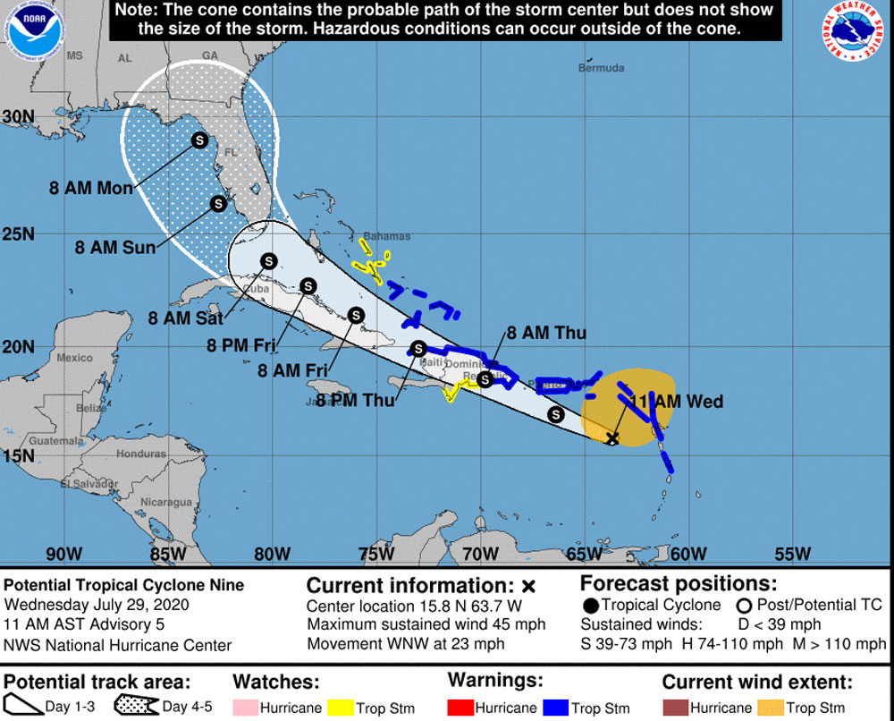
A tropical cyclone moving over the Caribbean is not expected to bring ore than wind and rain by Saturday evening or Sunday morning to the Flagler region, and current forecasts don’t see it developing into a hurricane, according to the National Hurricane Center. But Palm Coast government intends to ramp up its emergency operations just in case.
As of 11 this morning, Tropical Cyclone Nine was still not developing into a named tropical storm–what would be called Tropical Storm Isaias–as it moved west northwest with sustained winds of 45 miles per hour, at 23 miles per hour. Tropical storm warnings were in effect from the Lesser Antilles to parts of the Bahamas and Puerto Rico. The National Hurricane Center was seeing a lot of uncertainty in the storm’s development, while a European forecasting model currently does not see it as much more than a tropical depression, weaving its way between Cuba and Florida and losing steam in the Gulf.
“The models showed four days ago that it was near Bermuda,” Palm Coast Fire Chief Jerry Forte said this morning during a city town hall. “Two days ago it showed it was near the eastern side of the Florida coast. Today it’s showing it’s in the western side of the Florida coast, in the gulf, and we’re expecting it to move further west as time goes on. So it’s a good way that we can start cleaning out the cobwebs and making sure that we’re doing what we’re doing. But we’re ready to ramp up a second emergency management team to handle both the covid and the hurricane season as well. We’re looking at Friday having another meeting, both with all the executives and the department teams, and then Sunday might see some wind or rain from the effect. But I don’t believe we’re going to get the onslaught of a major hurricane or a Category 1. That looks ominous when you start looking at the cone of trail the hurricanes would bring. This is going to be a wind event, kind of like a ‘noreaster we’d see in March coming out of Georgia or the Atlantic area.”
Based on the storm’s current track, the National Hurricane Center estimates the most likely arrival of tropical-storm-force winds between Saturday night and Sunday morning in Flagler. The storm’s more serious effects are expected over the next hours and days in the Caribbean, with “potentially life-threatening flash-flooding and mudslides across the Leeward Islands, the Virgin Islands, Puerto Rico and the Dominican Republic,” according to the NHC’s latest advisory, with rainfall and wind hazards extending far from the center of the system.
There is more uncertainty beyond Thursday. “However,” the center cautions, “this system could bring some rainfall and wind impacts to portions of Cuba, the central and northwestern Bahamas, and Florida later this week and this weekend.”
The 2020 Atlantic hurricane season officially began June 1, though the first storm struck on May 16 and has since produced seven tropical storms and one hurricane. Hurricane Hanna made landfall in Texas Saturday–the first time a hurricane made landfall in Texas in July since Hurricane Dolly struck South Padre Island on July 23, 2008, with 100 mph winds.


Anonymous says
Not much more than wind and rain? Tornado watches, rain causes flooding and wind causes down power lines and trees. The most dangerous side of the storm is the East side of it. Soput fear in us over the virus, but downplay this storm that can change on a whim. Ok
Tyler says
Please don’t downplay with the “nothing bad will happen” mindset.
Just because it won’t attain hurricane strength doesn’t mean it won’t do anything. Yes the chances are lower but never zero. We’ve retired tropical storm names before.
Last year TS Imelda hit Texas with 45 mph winds (same as PTC9) and 1003mbar of pressure (almost the same as PTC9), yet it caused devastating flooding, $5bn in damage, and killed 6 people. Some areas received 43 inches of rain.
Just because it’s not Irma-geddon or Dorian 2.0 doesn’t mean you shouldn’t be ready for it.