Last Updated: 5:51 p.m.
The National Weather Service just before 5 p.m. issued a tornado warning for central Flagler County. A severe storm capable of producing tornadoes was over Bunnell, moving northeast at 30 miles per hour.
“There’s been no tornado touchdown, but we are tracking a rotating wall cloud, east of Palm Coast, it’s moving off to the northeast really quickly,” Flagler Emergency Management’s Bob Pickering said at 5:19 p.m. The wall cloud was to the west of Varn Park, on the barrier island, north of Flagler Beach and Beverly Beach.
“I’ve got trained spotters with eyes on it right now,” Pickering said. “It’s rotating and it can touch down at any point.”
The warning expired with no confirmed report of a touchdown.
![]()
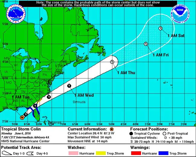
A disorganized and scattershot Tropical Storm Colin is set to cross Florida late tonight into Tuesday, dropping between 2 to 5 inches of rain on Palm Coast and Flagler County, with potentially heavier totals of up to 8 inches in localized areas. The heavier precipitations are expected starting in early afternoon Monday. The National Weather Service includes Palm Coast in its tropical storm warning zone through at least 1 p.m. today. That warning window was then extended to evening hours.
“The worst of the storm happens between 1 a.m. and 3 a.m. as far as our area,” Steve Garten, the county’s emergency services manager, said this morning.
Winds will blow at 30 to 35 mph, with occasional gusts exceeding 40 mph. A tornado watch is possible this afternoon, Bob Pickering, the weather specialist at Flagler County’s Emergency Operations Center, said, but that likelihood is at 5 percent.
“Depending on how all this plays out will determine how much rainfall we’ll get,” Pickering said. He stressed that the storm is widely disorganized as it moves northeast, making precise forecasts difficult. “We just don’t know if the rain will hang out north of Flagler or on top of Flagler,” he said. “You could get that one cell over one particular point that dumps a lot of rain then five miles away, not so much.”
Pickering said residents should not focus too much on the center of the storm, as heavy activity extends east of the storm. “The county is at the southeastern tip of the warning area,” Garten said. “The warning means we could possibly see sustained winds in excess of 39 mph for one minute or more.”
Florida declared a state of emergency Monday morning, and the Flagler County Commission followed suit as part of a previously scheduled special meeting this afternoon, at 3 p.m. The declaration is in effect at least seven days. The state of emergency declarations are driven mostly by funding requirements, not necessarily by the severity of the storm: making an emergency declaration qualifies a government for state and federal dollars, should damage from the storm exceed a certain threshold. That threshold is not expected to be exceeded in Flagler County.
Pickering described the overall conditions as not too dissimilar from severe summer storms, except that in this case the conditions may recur over several hours.
The National Weather Service’s big picture sees Colin tracking across the eastern Gulf of Mexico today and approaching the Florida Big Bend this evening. The storm will then track northeast across Northeast Florida tonight. Waves of showers and thunderstorms will move across the area this morning, then a more widespread heavy rainfall will traverse the area later this afternoon and into tonight as Colin moves across the area. Colin is expected to track northeast and away from the local area early Tuesday morning.
Emergency officials recom,mending signing up for CodeRED weather warning notifications here. Should shelters become necessary, the link for residents with special needs is here.
The city of Palm Coast has a sandbag station open at the Public Works yard at U.S. 1 and Wellfield Grade (just north of the FDOT weigh station) in Palm Coast. The Frieda Zamba Swimming Pool will be closed today (June 6). And the Palm Coast Citizens Academy class at Water Treatment Plant 3 is canceled for tonight. In early afternoon, Garten said sand bags would be made available at the county’s Station 71 on County Road 2006.


Leave a Reply