Last Updated: 11:32 a.m.
Note: A tornado watch is in effect for Flagler County until 7 p.m. See the National Weather Center’s full briefing here or below.
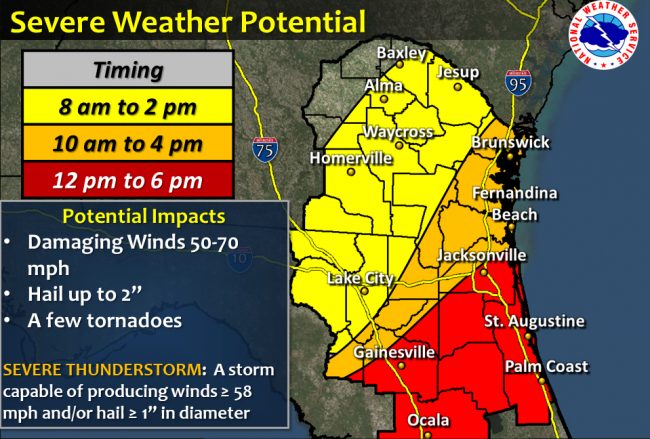
If the damage severe storms caused across Alabama and Mississippi Monday is an indication of what’s ahead for Flagler County and Northeast Florida Tuesday, you may want to take extra precautions in preparation of the day: the National Weather Center predicts a potential for severe storms and “a few tornadoes” in the region from noon to 6 p.m. today.
This morning’s weather service briefing calls for isolated thunderstorms that could nevertheless become strong to severe in the morning. Then, southwest winds are expected to increase in early afternoon to 20 to 25 mph, with gusts of up to 40 mph possible. The area of thunderstorm is expected to increase across the area as a cold front moves through. “Strong to severe thunderstorms will become more likely. Damaging winds, large hail of up to 2 inches and a few tornadoes are possible,” the weather service reports.
The thunderstorm threat will diminish by evening, when the temperature will have fallen precipitously (it is expected to be in the 40s in Flagler tonight) but a small craft advisory will be in effect on coastal waters.
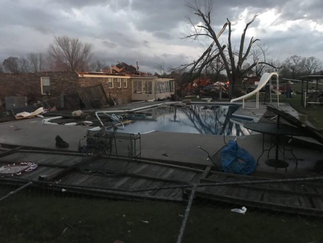
Monday’s storms spawned tornadoes across northeast Alabama, damaged homes and structures at Jacksonville State University, left some 10,000 customers without power, according to the Birmingham News, and required the closing of several roads and neighborhood, restricting the neighborhoods to people with IDs proving local residency. Jacksonville imposed a curfew starting at 6 p.m. Ardmore, Alabama, showed the signs of a tornado strike after homes were left without roofs and garages.
In Mississippi, images circulated on social media showed significant hail accumulation.
At 11:30 a.m., the Storm Prediction Center issued the following bullet points:
At 9 a.m., Bob Pickering, Flagler County’s weather specialist, sent the following memo to local weather spotters and others:
The Storm Prediction Center has maintained an Enhanced Risk on Tuesday March 20, 2018. This means the numerous severe storms are possible in the area today.
– The primary risk will be straight line squally damaging winds of 50-70 mph in any severe storm. (30% chance)
– Hail of up to 2” in diameter is also possible (30%) chance
– Tornadoes are also possible to a lesser extent (10%chance)
– Breezy to windy conditions are expected today
NWS Bulletins in place for Flagler County:
– Enhanced Risk for severe storms through 6 PM
– Wind Advisory from 12:00 PM through 8:00 PM today
REMEMBER – Watch means severe weather is possible Warning means it has been detected or spotted, take shelter!
Timing and Coverage:
– Our highest potential will be between 12 Noon (1200hrs) and 6:00 PM (1800hrs) Likely the latter part of that
– Storms are expected to come in clusters so several rounds are possible
– Storms will be localized, some areas may see them, other areas may get missed altogether.
Safety Advice:
– Heed all warnings quickly. Some of these storms will move fast
– Make sure you have a way to get warnings
– Review your severe storm and tornado safety plans (It is always a good idea to do that)
Resources for up to date info: There is uncertainty on how this will play out. Stay informed with the links below.
Latest NWS Briefing here(always updated with the latest): http://www.weather.gov/media/jax/briefings/nws-jax-briefing.pdf
Latest local weather briefing can be found here: http://www.flaglercounty.org/beach_live_stream/flagler_county_weather.php
Latest local weather forecast and radar can be found here: http://forecast.weather.gov/MapClick.php?zoneid=FLZ038
Storm Prediction Center: http://www.spc.noaa.gov/
Sign Up for Alert Flagler www.FlaglerCounty.org/AlertFlagler
Social Media www.Facebook.com/FlaglerEOC or www.twitter.com/FlaglerEM

Click to access nws-jax-briefing-7.pdf


Leave a Reply