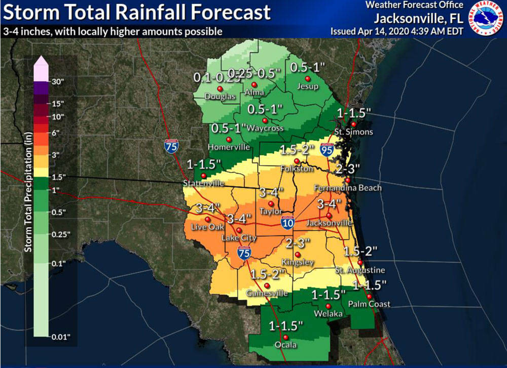
Much-needed rain and some thunderstorms are in the forecast for Tuesday and Wednesday, with rain totals of up to 1.5 inches in the Flagler-Palm Coast region, according to the National Weather Service.
A weather front is expected to stall over the region, its most severe potentials concentrated along the I-10 corridor from Fernandina Beach to Live Oak. The weather system is expected to spawn a few thunderstorms in the Flagler region. There is a low potential for tornadoes, but there is some possibility of damaging winds of up to 60 mph, and some hail.
The last time the county got severe weather goes back to the last day of March, when storms felled some trees and caused isolated power shortages. But stormy days have been unseasonably few, raising concerns about drought and fire conditions.
Average rainfall for March is over 4 inches. Most areas of the county got less than 1 inch, and some areas, including Palm Coast, got half an inch. Year-to-date rainfall should be approaching 10 inches by now. It’s been 2.4 inches in Flagler Beach, 3.26 in Palm Coast, according to figures compiled by Bob Pickering, Flagler County’s emergency management weather specialist.
The U.S. Drought Monitor indicates that Flagler County is “abnormally dry” and that drought development is likely into June. The county’s drought index has inched back over 400 on the drought index (zero is saturated ground, 800 is maximum drought conditions). When the index is in the 400 to 500 range, wildfires pop up more easily, as one did in west Flagler over the weekend. Fire departments besieged by the coronavirus emergency are hoping that their resources will not be diverted to fire emergencies. Neighboring counties have already declared burn bans to reduce any possibility of errant fires. Flagler County Fire Chief Don Petito and Emergency Management Chief Jonathan Lord last week said that is being discussed for Flagler as well.
High temperatures today and Wednesday will be in the mid- to upper 80s, cooling Wednesday night and Thursday.
![]()
9


Leave a Reply