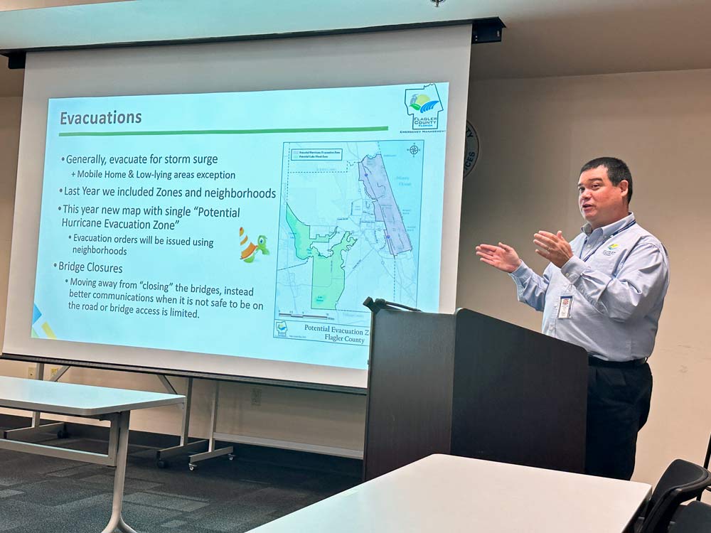
After years of confusion, Flagler County is finally replacing the way it refers to evacuation zones with a much more intuitive approach.
It no longer will be “Zone A,” “Zone B” and so on–zones few people could keep straight and fewer still didn’t confuse with Palm Coast’s strange custom of referring to its subdivisions by the same letters. Rather, county emergency officials have adopted zones specific to the way residents know and refer to their own neighborhoods.
For example: Seminole Woods or the Woodlands in Palm Coast, the Lambert Avenue neighborhood in Flagler Beach, the Mondex, or Daytona North, in western Flagler. In Palm Coast, evacuation zones may still carry letter identifiers, but only in reference to the city’s sections: The P Section, the B Section, the L Section. Even then, evacuation orders will generally be more specific to neighborhoods within each section, delineated by major streets.
Flagler County Emergency Operations Director Jonathan Lord outlined the new system during his annual round-table for media ahead of the hurricane season, which begins June 1 and runs through Nov. 30. (See the full powerpoint presentation here.)
The change in referring to evacuation zones was made possible by better flood-forecasting technology that now narrows down flood-prone zones more specifically during storms. That will enable emergency officials to limit evacuation orders to neighborhoods rather than to any of the six larger swaths that made up the previous zones.
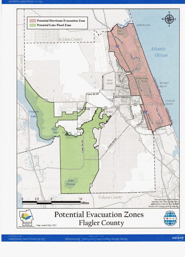
The confusion is not entirely gone. The county is still maintaining two very large potential evacuation zones in addition to its neighborhood-specific zones: what will be known as the Pink Zone includes the entirety of the barrier island and all the mainland up to I-95, plus a few slivers of land and neighborhoods west of 95. Those are the areas most likely to be affected by a storm surge, with decreasing likelihood as the zone goes west.
The Green Zone is a more jagged area in western Flagler. It looks more like those recent-vintage congressional districts that seem to have no logic. In this case the zone follows the contours and watersheds of Dead Lake, Crescent Lake and water bodies that are directly connected to the Intracoastal, and would rise and fall as the Intracoastal does, causing serious flooding in major storms, as Hurricanes Nicole and Ian did last Year (even though neither storm struck Flagler County with more than tropical storm force winds).
“We do not take ordering evacuations lightly. That’s something we take super seriously,” Lord said. “We want to make sure we are super sure. I will still tell you, we’re going to err on the side of caution. And just like with the last couple of storms, we evacuated the entire barrier island. But the flooding was only focused in a couple areas. That’s going to happen all the time. The weather forecasting is not perfect. But I’d rather you be upset that I over-evacuated you because you were on the island or anywhere else in there, than you not be alive in the first place. So it’s super important that you take that seriously.”
Lord said there is no such thing as a voluntary evacuation order. “All of our evacuation orders in Flagler County are mandatory,” he said. Nevertheless, it’s the sort of mandatory that has no force of law or policing: “We’re not going to go drag people out of their homes. It is a personal choice,” Lord said.
People who choose to stay behind have the right to do so. But they do not have the right to expect emergency services should something go wrong. They stay behind at their own risk, whether they fall ill or get flooded out or their roof caves in at a time when emergency personnel may not be able to get there.
There’ll be another change this season: you will no longer hear that the Flagler Beach bridge and the Hammock Dunes bridge are “closed,” as has been the case in previous hurricane seasons at times. That sent the wrong message to residents, who feared that they could not get out of the island even when they wanted to. Instead, emergency officials will refer to restricted bridge access, and only eastbound, where there will still be police barricades checking on who is seeking to cross.
The hurricane season is expected to be on the “average” side, as the National Oceanic and Atmospheric Administration (NOAA) refers to it–to the extent that any hurricane season may be referred to as “normal” anymore: as misnomers go, that one comes with a caution, especially for Florida residents, who thought the 1992 hurricane season had been a “quiet” one–until Hurricane Andrew leveled South Florida with the approximation of a nuclear blast in mid-August. “The key is not to get complacent,” Lord said.
With 70 percent confidence, NOAA is forecasting 12 to 17 total named storms of tropical or hurricane-wind strength (a tropical storm has sustained winds of 39 mph up to 73 mph. It becomes a hurricane at sustained winds of 74 mph). Of those, five to nine could become hurricanes, including up to four major hurricanes with winds of 111 mph or higher.
Colorado State University is the other organization that produces the most sought-after forecasts. CSU is forecasting 13 named storms (the average since 1991 has been 14.4), with 55 days in the next six months seeing a named storm or more somewhere (the average is 69). CSU is forecasting that six of those storms will reach hurricane strength, two of them as major hurricanes. Both CSU and NOAA will provide an updated forecast in August.
According to NOAA,the season is expected to be less active than recent years due to competing factors, some that suppress storm development, like El Nino, and some that fuel it, such as warmer-than-normal sea surface temperatures. The combination of the two produces the “near-normal season.”
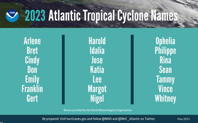
The named storms will begin with Arlene, then Bret, Cindy, Don, Emily, Franklin, gert, Harold, Idalia and so on.
Lord is reasserting the usual preparatory cautions. Flagler residents should use this period of relative calm to prepare their emergency or disaster kits. (See below.) They should pre-arrange their evacuation plans, so they know where they will go–with family, with friends, with city residents in other parts of the city–and leave going to a shelter as a last resort. They should have AlertFlagler, the county’s free emergency alert system, loaded and calibrated to their preferences on their phones.
Theft should also be aware that next to storm surges, the largest number of people are injured or die after a storm has passed, in the immediate aftermath, as hubristic heroism and impatience rather than caution take over: People with little or no experience with chainsaws getting on the roof to cut away fallen limbs, and ending up injured or killed by the chainsaw or by a fall. People who die from carbon monoxide poisoning from mis-positioning their generator, or from electrocution from mishandling the generator. People who eat spoiled food from their unpowered fridge. People who decide to sightsee around downed power lines that may be live.
It comes down to “just being aware of what’s going on around you, and not doing things that you haven’t really done before,” Lord said.
![]()















Shelley Kleinfelder says
We might want to try neighborhood names like Pine Lakes or Lehigh Woods or Palm Harbor or Belle Terre. Signage is still in place so names sound better than the x section!
Atwp says
I thought I was confused before, more confused now.
S.Peters says
Me too
pete says
Stand by and im sure before its over you will be even more confused. It will be all screwed up before its over it’s ever over.