The National Oceanic and Atmospheric Administration’s Climate Prediction Center today issued a forecast for a likely range of 13 to 20 named storms with winds of 39 mph or higher this Atlantic hurricane season. Six to 10 storms could become hurricanes (winds of 74 mph or higher), including three to five major hurricanes (category 3, 4 or 5, with winds of 111 mph or higher).
NOAA provides these ranges with a 70% confidence. The Atlantic hurricane season extends from June 1 through November 30.
The forecast is a bit more expansive than Colorado State University’s annual predictions, which set precise numbers. Issued on April 8, Colorado State’s forecast calls for 17 named storms (the average since 1991 has been 14.4), 80 named storm days (the average is 69), eight hurricanes (almost in line with the average of seven since 1991), and four major hurricanes.
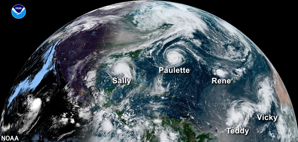
It all adds up to another above-normal Atlantic hurricane season. NOAA says there’s a 60 percent chance of an above-normal season, a 30 percent chance of a near-normal season, and a 10 percent chance of a below-normal season. Experts do not anticipate the historic level of storm activity seen in 2020, when there were some 30 named storms, including 13 hurricanes and six major hurricanes. There were so many storms that NOAA ran through its prepared list of storm names that year, from Arthur to Wilfred, and started a whole new cycle with weirder names pegged to the Greek alphabet (Alpha, Beta, Gama, making it all the way to Iota).
None impacted Flagler County.
For all the predictions, Flagler County Emergency Management Chief Jonathan Lord cautions that the numbers may all be irrelevant. “The focus on the forecast to me is truly irrelevant as well,” he said today, just after NOAA issued its forecast. “And I’ll tell you why. If we have the quiet of hurricane season ever on record, and let’s say it’s only one hurricane, and that one hurricane comes here, it didn’t matter that it was the quietest season to the community that was impacted. In the same token, last year we had a record hurricane season, 30 named storms I think at the end of the year. Not one of them truly came here because to us it was the busiest season ever, but it didn’t come here. I always tell folks that, listen, the forecast is great, it’s a great tidbit to show on the news, for the Hurricane Center to talk about, the Colorado State University to talk about, AccuWeather does their own forecast, all these groups do their own forecast now. At the end of the day, it only takes that storm coming to you. Doesn’t matter what that forecast said at the beginning of the year or the middle of hurricane season.”
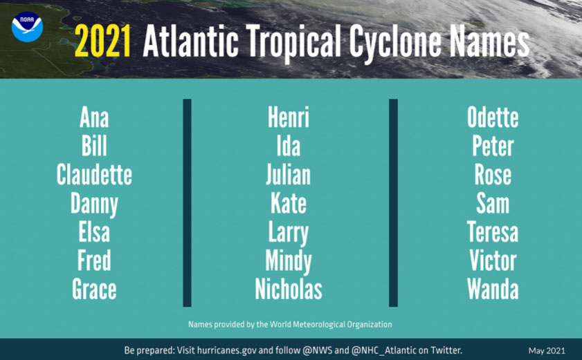
Here are this year’s names:
Lord also cautioned against focusing on the categories of hurricanes or whether they’re hurricanes at all. Storm surges aside, Hurricanes Matthew and Irma, in 2016 and 2016, did not impact Flagler County as hurricanes but as tropical storms. They were both still devastating, severing most of the county from power for days, downing trees, ripping off roofs, and in Irma’s case, flooding vast sections of Flagler Beach.
“So for us and every storm out there is different,” Lord said. “One Category 3 storm does not look like another Category 3 storm. You can have a Category 3 storm–I’m just picking that one randomly–you have a Category 3 storm with a minimal storm surge and another one is with a storm surge that approaches I-95. In theory, the chance that a wall of water makes it to I-95 is pretty slim. But you’re going to definitely see water building up and flooding because of that, potentially past I-95.”
Lord said NOAA and National Weather Service forecasters have made new improvements in forecasting technology, as they do almost every year, with the famous cone of probability narrowing a bit, to reflect its slightly more precise parameters, though again, the cone should not be misinterpreted, Lord said. Here are some changes and improvements, notably with storm-surge tools that take into account the very significant effects of sea rise, from global warming, on the magnitude and consequence of storms:
- In March, NOAA upgraded the flagship Global Forecast System (GFS) to improve hurricane genesis forecasting and coupled GFS with a wave model extending ocean wave forecasts from 10 days out to 16 days. Additionally, Global Positioning Satellite Radio Occultation (GPS-RO) data are now included in the GFS model, providing an additional source of observations to strengthen overall model performance. The GFS system is often compared to the European forecasting model, which has consistently been somewhat more precise than GSF.
- Forecasters at the National Hurricane Center are now using an upgraded probabilistic storm surge model — known as P-Surge — which includes improved tropical cyclone wind structure and storm size information that offers better predictability and accuracy. This upgrade extends the lead time of P-Surge forecast guidance from 48 to 60 hours in situations where there is high confidence.
- NOAA’s Atlantic Oceanographic and Meteorological Laboratory will deploy its largest array of air and water uncrewed systems to gather data designed to help improve hurricane intensity forecasts and forecast models. New drones will be launched from NOAA Hurricane Hunter aircraft that will fly into the lower part of hurricanes, and in the ocean, saildrones, hurricane gliders, global drifters, and air-deployable technology — called ALAMO floats — will track various parts of the life cycle of tropical storms.
Flagler County Emergency Management uses a tool issued by the National Weather Service in Jacksonville to determine storm surges and storm surge warnings. That tool “showed where the water would go,” Lord says. “So that is the last tool we use right before we make the evacuation call is that actual live product, and that product gives us the surge tide, the storm tide, above mean high water, which is the average current tide levels that we see today. So it does take into account that sea levels have risen because it’s based on your current average.” The data is all publicly available on the Weather Service’s website.
The cone of probability must be read cautiously, Lord said: “The caveat I want to give out there though is the cone shows where the center of the storm may lie, it is not the extent of the hurricane force, the tropical storm force winds. The cone truly shows anywhere in that cone where the center of the storm may lie. So that hurricane is coming up the Atlantic Ocean, let’s say, heading north, coming along our coastline. Let’s say the cone is 20 miles off of the Flagler County coastline. That cone is just showing where the center of that storm may be. If the storm is 100 miles wide, that puts that storm and those wings directly on top of Flagler County, even though the cone is showing being off the coasts. So that’s a misnomer, it’s unfortunate, a lot of people see it, they’re going to watch the cone on the news or on the internet and on the TV news and say, well, Flagler County is not in the cone. Well, it doesn’t really matter, because that cone is just showing the center of the storm, the eye of the storm, not the actual extent of wind out from the center.”
“With hurricane season starting on June 1, now is the time to get ready and advance disaster resilience in our communities,” said FEMA Administrator Deanne Criswell.
![]()


marlee says
above-normal Atlantic hurricane season??
…..and they keep approving and building housing developments along A1A.
A Concerned Observer says
Reality Check. Sensationalized stories sell advertising, which is the compelling reason for the hype in television dramas, reality shows, talk and most unfortunately, even news stories. This seems to be the case today more so than some years ago. The personal bias of the presenter or their corporate owners is also rampant from these sources. Even election polling (see related story also currently in Flagler Live) is also colored by this phenomenon. The only defense the readers or viewers have is to take the account of as many sources as possible and draw their own, hopefully informed, realistic conclusion. When you hear that they are running out of names to report on storms, remember that not so many years ago, only storms that rose in intensity to be categorized as an actual, and not merely possibly serious storms. But back then it wasn’t deemed sexually biased to have hurricanes only use feminine or every conceivable ethnic names so as not to offend anyone. Only recently have simple snowstorms in the northeastern United States been elevated to “Named Storm” notoriety. Society is beyond the tipping point, with the average consumer is considered to be in need of being manipulated and no more capable of forming their own realistic opinion than a heard of sheep. This begs the question why was this deemed necessary? To sell soap!
Steve says
IMO in the recent Past most middle Age and above were capable of separating Fantasy from Reality. Seems some are Victims of the blur between those brought on by the Modern Forms of Communication and One seeking the reassurance
of Public Self Gratification in a World anything but Social. The Forum or Space has Changed to a Degree of Virtually accepted representation one’s Looking Glass Selves in the eyes of our beholden. No Wonder right? The Anonymity of a keyboard …..Its not so much the Media but the Medium in which its delivered and said recipients use of