


Last Updated: 5:12 p.m.
Note: WNZF and three other Flagler Broadcasting radio stations will have storm updates at 10 a.m., 2 and 4 p.m. today. See Monday’s Milton reporting here.
Tuesday, 3:15 p.m. update–Ahead of Hurricane Milton, Flagler County officials are issuing evacuation orders this afternoon, to be in effect by Wednesday at 8 a.m., at the same time that a special needs and general-population shelter will open at Rymfire Elementary in Palm Coast (1425 Rymfire Dr, Palm Coast). Officials urge those evacuating the county to do so today, to keep roads clear Wednesday morning for those heading to the shelter.
The evacuation zones include all the barrier island from Marineland to Flagler Beach, and on the mainland all the neighborhoods off of John Anderson Highway, Palm Drive, Labert Avenue, Bulow Park, Ashley Way and Polo Club West neighborhoods, plus Palm Coast Plantation north an d south of River Park Drive.
County Emergency Management Director Jonathan Lord announced the evacuation order at a 3 p.m. press conference at the Emergency Operations Center in Bunnell, where he was flanked by other local county and city officials, the superintendent of schools and the sheriff.
“My message is let’s work together, let’s heed the warnings to prepare,” Sheriff Rick Staly said.
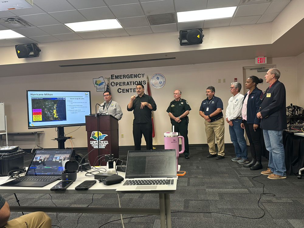
“I urge you to take all measures to keep yourself safe,” Flagler Beach Commission Chair Scott Spradley said. Palm Coast Mayor David Alfin put his trust in the collective experience of the local leadership, calling himself “comfortable” with the preparations he’s witnessed. “Take a moment introduce yourself to your neighbor,” Alfin said. “This is that time you can be begin to feel that sense of community and be prepared to help one another.”
There will be a curfew from Wednesday at 7 p.m. to Thursday at 7 a.m. The sheriff hopes it will be for just one night. He cautioned that when winds reach 45 miles per hour, emergency responders will not respond to calls. “We’re not going to risk the safety of responders because you failed to prepare or refused to prepare to evacuate,” he said, “and we’ll get you as soon as weather allows to, or we’ll get your remains, whatever it may be.”
Officials sought to reassure the public that despite local personnel going out of county to help other localities recover from Hurricane Helene, all crews are at normal capacity now.
In Palm Coast, the city has lowered canals to accept more rainfall into the system while considering the outfalls in wetlands and conservation areas. “All that is being modeled by or stormwater system,” Palm Cost City Manager Lauren Johnston said.
Police teams in Bunnell and Flagler Beach have gone on A-B 12-hour shifts. The Flagler County Sheriff will maintain a three-shift approach.
“It’s dangerous during the storm, but it is most dangerous after the storm,” Staly said, warning of debris and other hazards that will have yet to be cleared. “That’s usually when most deaths occur and most injuries occur–is after the storm.”
As for power restoration after the storm, “I feel very comfortable that we will get support from FPL. It may not be as fast as people hope,” Lord said, but the company will tackle critical infrastructure first, then turn to other areas.
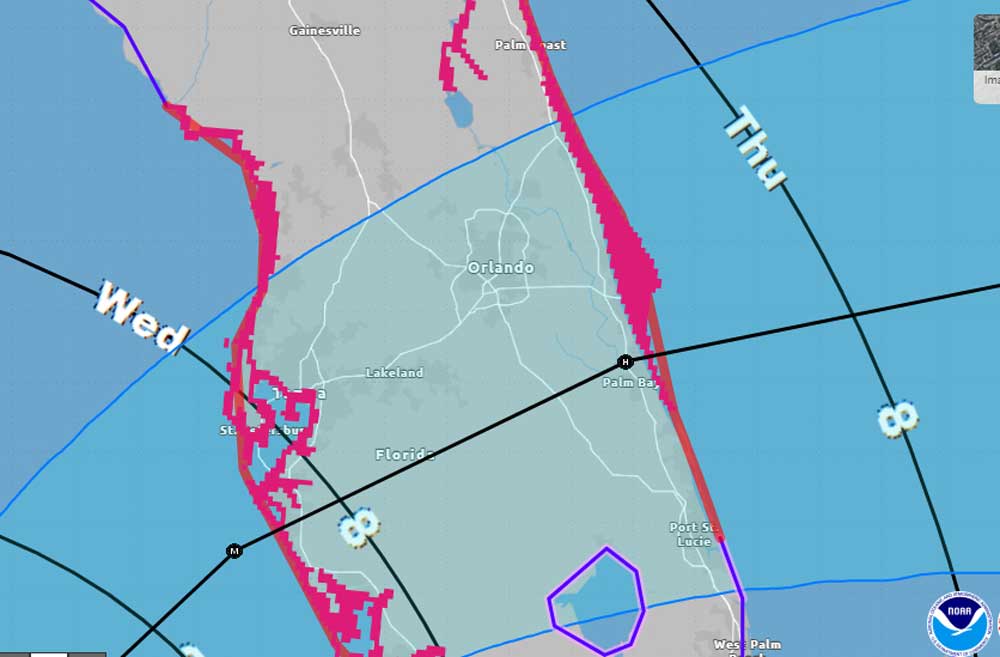
At 5 p.m. Tuesday, Hurricane Milton had again strengthened to 165 mph sustained winds and was again a Category 5 storm some 480 miles southwest of Tampa, moving east at 9 miles per hour. But the storm track had shifted further south toward Palm Bay, with landfall now expected south of Tampa Bay. Much of Flagler County is now out of the cone of probability. That is relieving some pressure and anxieties on officials and residents in Flagler County.
![]()
Hurricane Milton’s projected path has remained remarkably steady with very slight variations north or south, but with models agreeing on landfall in the Tampa Bay area after midnight Wednesday and now mostly merging to agree on a path along or a bit south of I-4, toward Merritt Island and the Space Coast, where it would exit, still as a hurricane, Thursday afternoon.
“But again, please don’t focus on the center of the cone,” Flagler County Emergency Management Director Jonathan Lord said this morning. “Definitely expect the eye can travel anywhere within that cone, and potentially outside of the cone. Sometimes, that’s why the cone shifts. But again, this cone hasn’t shifted too much.”
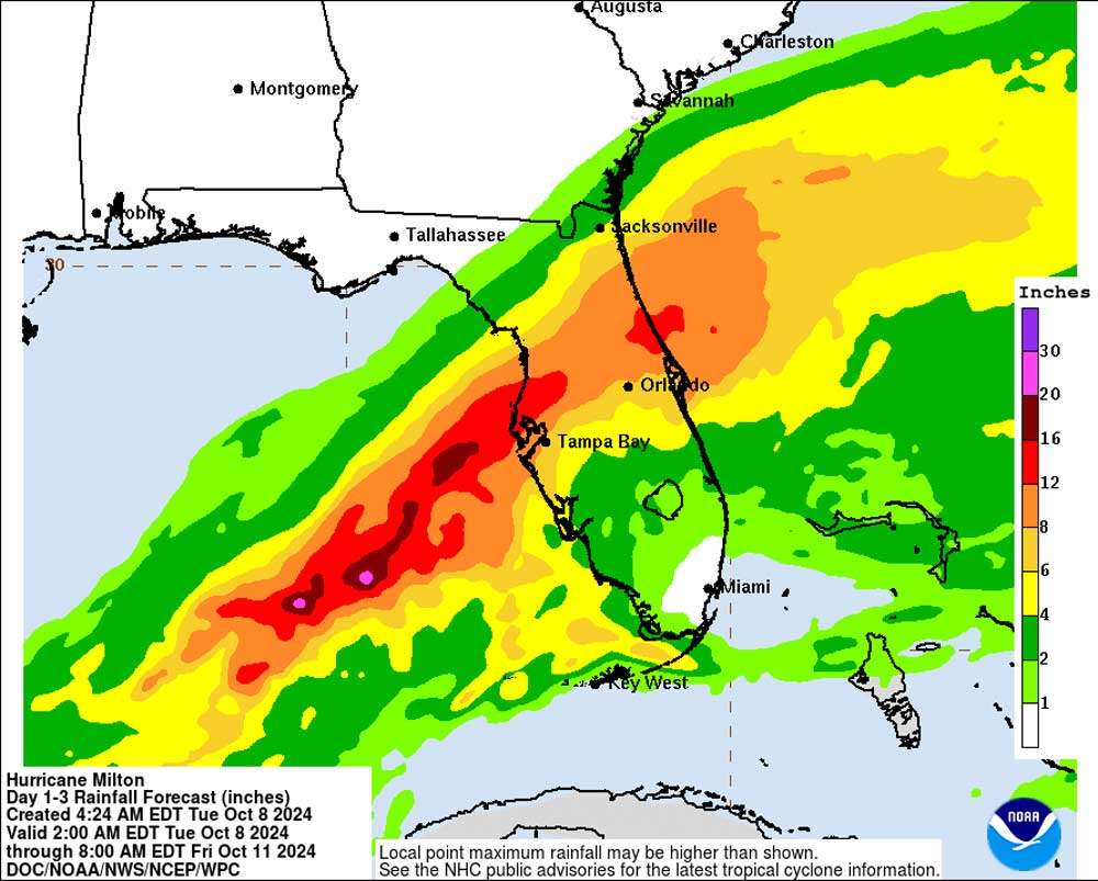
The storm’s nearly 12-hour crawl across the state is slower than previously estimated, and the size of the storm is growing larger–two factors that will compound damages and dangers and likely increase the extent of power cuts in the storm’s path and its rain-heavy northern front, which includes Flagler County. Conditions will deteriorate in Flagler Tuesday night, but most local impacts are expected Wednesday afternoon through Thursday, according to the National Weather Service in Jacksonville.
Tropical-storm force winds ranging between 40 and 70 mph are expected in Flagler County, with the possibility of hurricane-force winds especially on the barrier island. A very slight change either way could have significant consequences for the Flagler-Palm Coast area, especially if the storm wobbles north. The entire county remains in the storm’s cone of probability, which means the storm could cross any portion of the county.
Flagler County is facing a heavy rain event, with “extreme flooding rain” in the southern third of the county. That includes Seminole Woods and Quail Hollow in Palm Coast and Hunters Ridge in the unincorporated part of the county, and on the barrier island, including Flagler Beach and Beverly Beach. The National Weather Service places rain totals at 10 to 15 inches for the county–or possibly more than a foot, on already saturated grounds. Tree falls will be more frequent because of weakened roots and strong winds. A flash flood watch is in effect for the whole county.
“This is a generalization, because every storm is different,” Lord said. “If you saw flooding in Irma, Ian or Nicole, you are likely to see flooding with this storm in our community. That does not mean that you’re guaranteed. You might end up with a dry lawn, and may end up with a wet lawn if you’re on the waterways and say, Well, I didn’t have it in Irma. Every storm is different, but the good generalization is Irma, Ian or Nicole, if you saw water in many one of those storms, there’s a good chance you’re going to see water again in this storm.” That goes for “the bulk of the barrier island,” he said.
The local storm surge along the coast and the Intracoastal is expected to be around 3 to 5 feet–severe enough for low-lying areas and homes along the Intracoastal, such as Flagler Avenue, Lambert Avenue and Palm Drive in Flagler Beach to be affected. Those are among the neighborhoods that will likely be facing evacuation orders. Some evacuations are expected to be announced today in Flagler, as will the opening of shelters in Palm Coast. The shelter will open at Rymfire Elementary for special needs, the general population, and residents with pets.
A 2 to 4 foot storm surge is also expected along the St. Johns River Basin, including Crescent Lake, which will affect western portions of Flagler County. A Storm Surge Warning has been issued from the Volusia/Brevard County Line northward to the mouth of the St. Mary’s River, including the St. Johns River. A Hurricane Warning is now in effect for the east coast of Florida from the Indian River/St. Lucie County Line northward to Ponte Vedra Beach, including all of Flagler County’s coastline.
The storm is a still-major Category 4, with winds of 145 miles per hour, with further fluctuations in strength expected over the next 48 hours before landfall, “but there is high confidence that Milton will remain an extremely dangerous hurricane when it reaches the state,” the National Hurricane Center said in its early-morning advisory. But it will weaken after landfall.
“A large area of destructive storm surge will occur along parts of the west coast of Florida. This is an extremely life-threatening situation and residents in those areas should follow advice given by local officials and evacuate immediately if told to do so,” NHC states.
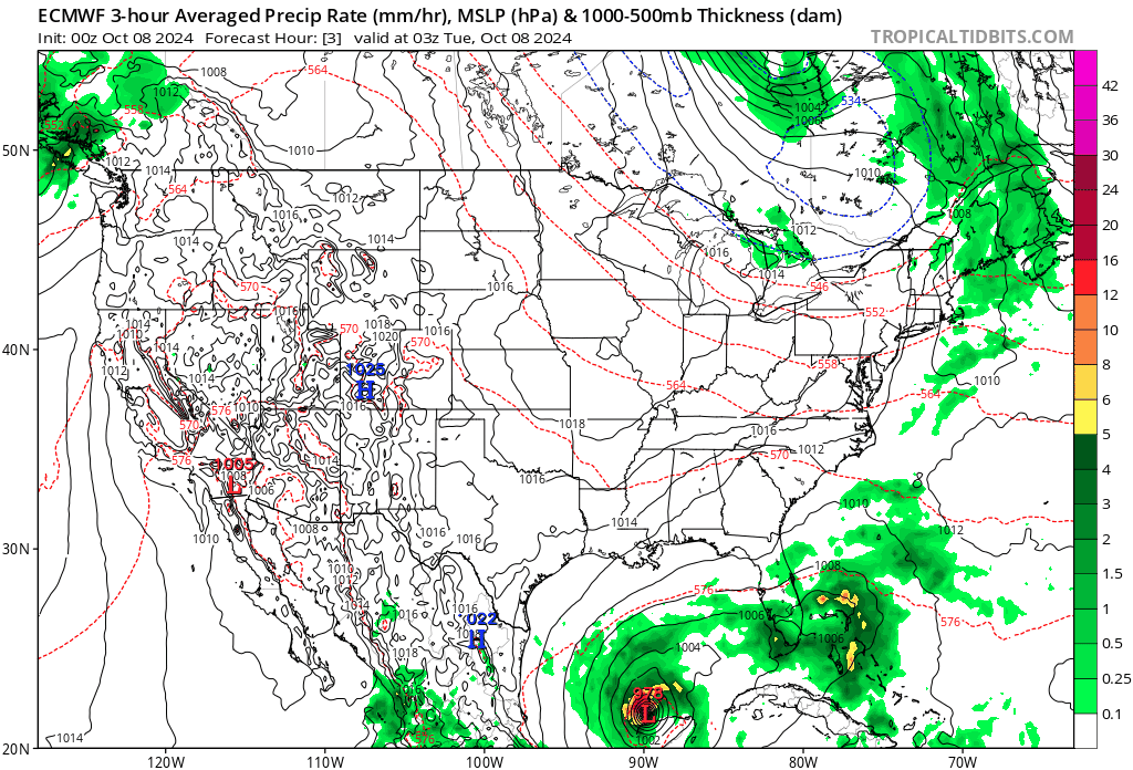
At 8 this morning Hurricane Milton was 545 miles southwest of Tampa, with sustained winds of 145 miles per hour and moving east northeast at 12 mph. It went through an eyewall replacement cycle overnight, which weakened the strength of the storm while expanding it. Eyewall replacement cycles are common with large storms, causing fluctuations in their intensity. Milton is expected to accelerate today as it continues to move toward Tampa.
![]()
- Indian Trails Sports Complex, 5455 Belle Terre Pkwy, Palm Coast. This is a self-service station, and residents must be able to fill and load the sandbags into their vehicles. Sand and sandbags are available. Please bring a shovel.
- 100 Fin Way at the corner of Belle Terre Boulevard south of State Road 100. This is a self-service station but assistance will also be provided beginning Monday, October 7, 2024, from 1 p.m. to 6 p.m. and again on Tuesday, October 8, 2024, at 8 a.m.
- Flagler Beach: Santa Maria del Mar Catholic Church, 915 North Central Ave., Monday starting at 9 a.m.
- Flagler Beach Fire Station, 320 South Flagler Avenue, Monday starting at 9 a.m.
- Hidden Trails Community Park in the Mondex, 6180 Mahogany Boulevard, Bunnell, from 10 a.m. to sunset.
- Bay Drive Park, 30 Bay Drive in the Hammock, from 10 a.m. to sunset.
- In Bunnell, the sandbag station on South Pine Street behind Coquina City Hall is still running. The last sand delivery arrived the morning of October 8th. This station will operate today until materials – either sand or bags – are gone. There will be no operations for sandbags after Tuesday, October 8th.
![]()
POTENTIAL EVACUATIONS: While no evacuation orders are currently in effect, residents living in mobile homes, coastal communities, and other specified areas below are urged to prepare for possible evacuations. When evacuations are ordered, they are issued by neighborhood. More specific information will be provided in the coming days. If evacuations occur, a shelter inclusive of pets and those with special needs will be set up at Rymfire Elementary (1425 Rymfire Dr, Palm Coast, FL 32164).
- Residents living in Mobile Homes and RV’s Countywide
- Coastal / Island Communities
- The entire island from the St Johns County Line to the Volusia County Line
- Marineland through Flagler Beach
- Mainland Communities
- South of SR-100 (Moody Blvd)
- Neighborhoods off John Anderson Hwy
- Neighborhoods off Palm Dr
- Bulow RV Park & Homes, off Old Kings Rd
- Polo Club West / Sweetbottom Plantation properties along Lexington Court / Ashland Way and that back up to the Bulow Creek
- Between SR-100 (Moody Blvd) and Palm Coast Pkwy
- Neighborhoods off Lambert Ave
- In Marina Del Palm the properties along the Intracoastal Waterway / basin
- In Palm Coast Plantation:
- Properties off South / North Riverwalk Drive
- North of Palm Coast Pkwy
- Properties within Princess Place
- South of SR-100 (Moody Blvd)
![]()
Flagler County Schools will hold classes Tuesday but cancel all afternoon athletics and activities. Extended day will stay open until 6 p.m. Flagler schools will remain closed through Friday.
Daytona State College, the University of Central Florida and Stetson University are closing Tuesday and will remain closed through Thursday or Friday.
The Flagler County Supervisor of Elections Office will close at noon Wednesday, October 9 through Friday, October 11, reopening Monday, October 14. The Canvassing Board meeting scheduled for Friday, October 11 has been canceled. More information: Legal Notices
In Palm Coast:
- The City Council Workshop meeting scheduled for Tuesday, October 8, 2024, at 9 a.m. has been postponed and will be rescheduled.
- The groundbreaking ceremony for Fire Station 26, scheduled for Thursday, October 10, 2024, has been postponed and will be rescheduled.
- The Town Hall meeting with Council Member Pontieri, scheduled for Thursday, October 10, 2024, has been postponed and will be rescheduled.
- The Utility Drive lobby at 2 Utility Drive is closed to the public. All resources have been reassigned to storm-related tasks.
- Palm Coast City Hall, Community Center, Palm Harbor Golf Club, Southern Recreation Center, Palm Coast Aquatics Center, all parks, trails, and sports fields will be closed on Wednesday, October 9, and Thursday, October 10.
The Flagler County Public Library is closed Wednesday and Thursday, as will county government offices.
Flagler County courthouse closed Wednesday and Thursday.
In Palm Coast: Garbage collection services have been canceled for Wednesday, October 9, 2024, and Thursday, October 10, 2024. This includes yard debris and recycling. The next pickup day will be the regularly scheduled pickup day.
In Unincorporated Flagler County:
WastePro pick-up is cancelled Wednesday, Thursday for unincorporated Flagler County.
In Bunnell:
- City Solid Waste Service Changes already announced Thursday COMMERCIAL pick-ups will occur WEDNESDAY; THURSDAY residential services (Grand Reserve Golf Course) are CANCELLLED Thursday; if possible Grand Reserve residential could be picked up FRIDAY;
- City Solid Waste changes (NEW)– BULK PICK UP for FRIDAY, October 11th is CANCELLED
- City Solid Waste changes (NEW)- depending on City conditions (safety of roads), YARD WASTE pick-up may start as soon as FRIDAY, October 11th. Solid Waste trucks may also be working over the weekend to start YARD WASTE pick up. Yard Waste and other debris needs to be kept separate; DO NOT combine these piles and DO NOT place piles near obstructions like cars, power poles, mailboxes, etc. or under obstructions like power lines or cable lines.
Utilities and Metronet connections
Palm Coast water and sewer utilities: For any questions regarding City services like water, sewer, streets, or drainage, residents can contact Palm Coast Connect at palmcoast.gov/connect or call Customer Service at 386-986-2360. If you have a PEP tank and experience a power outage, limit water usage to avoid overflows or backups. More information on PEP tanks during a storm can be found at PEP tank storm info.
Metronet: With the impending impact of Hurricane Milton, Metronet is prepared and has prepositioned out-of-state crews to travel to assist with restoration of service in affected Palm Coast, Flagler Beach, and Bunnell. Beginning Wednesday, October 9, service installations or repairs have been suspended. Services will resume as soon as possible following the storm. Customers with a repair or installation scheduled have been notified about their cancellation and have been provided with details to reschedule. Metronet has been in close contact with local utility companies, city officials, FEMA, and State Emergency Management to ensure that our crews may enter critical areas to make necessary repairs following the storm’s impact, once it is safe to do so. As the storm nears, impacted customers will receive updates on local service status via the contact information provided in the Customer Portal. Any customer who has not signed up or needs to update contact information should visit portal.metronet.com.
![]()


Sherry says
More desantis political BS. . . he will most certainly have his hand out for federal disaster relief dollars. . . but, he still refuses to meet with President Biden. . . this from Politico:
The dispute between the White House and DeSantis comes after Biden visited Florida last week to survey storm damage from Hurricane Helene. DeSantis, however, held a press event across the state in another storm-damaged area — the second time the governor has skipped out on a presidential visit from Biden in the aftermath of a hurricane.
DeSantis similarly did not tour damage with Biden when Hurricane Idalia hit last year, while DeSantis was a presidential candidate.
“We were in Florida, we invited the governor of Florida to come, it was his decision not to attend,” White House press secretary Karine Jean-Pierre told reporters Monday. “The president has reached out around Hurricane Helene. He reached out. It is up to the governor, it is really up to the governor.”
Forget FEMA says
[Warning: this is an inaccurate comment that should not have been approved, though it reflects falsehoods being spread on certain networks and websites where fabrications are rampant. From NPR: “Rumors, misinformation and lies about the federal government’s response to Hurricane Helene in the southeastern United States have run rampant since the storm made landfall, especially around funding for the Federal Emergency Management Agency. The claims have become so widespread that FEMA set up a response page to debunk many falsehoods around how disaster funding works and what the agency’s response has been. As of Sunday, FEMA says it has provided more than $137 million in assistance to six states in the southeast, including 7,000 federal personnel, nearly 15 million meals, 14 million liters of water, 157 generators and more than half a million tarps.” Do not use this site to spread disinformation–FL]
Our Governor has much more important things to do right now than try to decipher one of Kamala’s incoherent babbling word salads. They haven’t even begun to repair N. Carolina, Biden is the lamest of lame ducks napping on the beach everyday, Mayorkas and FEMA is broke funding illegal aliens’ every need, I cannot think of a more worthless and valueless telephone call Desantis could field right now. AT Least he has Florida under control, watch how fast The State mobilizes after the storm. I see nobody in FEMA jackets walking door to door in the Smoky Mountains.
Deborah Coffey says
These are ALL lies and I’m calling you out! In fact, you should probably be arrested for putting people in grave danger. ALL LIES. You people are so gullible. You don’t even know “word salad” when you hear it.
Nephew Of Uncle Sam says
Wow, that’s just weird FF, lots of disinformation in your statement.
Laurel says
So what’s the weather like on Mars?
FlaPharmTech says
I am so very sorry you are so misguided. Peace and be safe, and embrace joy.
Steve says
More Kool aid or is swamp water ok for you. Hit all the talking points Now sit, want a treat.
FlaPharmTech says
No treat. He’s not a Good Boy.
YankeeExPat says
A five foot storm surge will drown the White supremist Meemaw and Pawpaw’s in their red MAGA hats just as fast as Liberal cross dressing Bud -Lite drinker in a Lemay Dress !
FlaPharmTech says
Why do you MAGAs revel in lies, conspiracy, confrontation and the promise of violence? Why do you hate the USA? Why do you hate your fellow Americans? Just WHY?????!!!!
JonQPublik says
Because their truths are to embarrassing to them to be voiced.
exfloridian says
Upstate SC here and you’re so right. The only heroes seen around here have been local and out of state volunteers, USAA, local business owners and churches handing out food and supplies, etc.
No Red Cross or FEMA spotted yet.
milton says
oh stop it, stay safe everyone.
Skibum says
The Vice President also reached out to DeSantis regarding support for hurricane efforts in our state, and our idiot gov refused to take her phone call. His ridiculous excuse was that he wasn’t aware that she had called!!! There is no way in hell that a governor is somehow “not aware” or told immediately when the Vice President of the United States is on the phone attempting to speak with him. His lame excuse, or better stated, LIE, is just that or he is totally incompetent and has incompetent people surrounding him. Which is it?
Multinational says
[Please comply with our comment policy. Thank you.–FL]
For someone who supposedly lives in Sausalito AND travels the world while continually putting down others, you seem to spend an inordinate amount of time pasting liberal articles on Flagler Live.
And this is a comment who does actually have a passport (more than one).
Sherry says
@multi. . . You’ve got some kind of “real” problem with me. . . bring it on! I see a BS “green eyed monster here”. Good for you for being one of only 12% of American who have a passport. Wow!
We are actually Floridians, born and raised. My ancestors immigrated to the southern part of the US in the 1600 from England, they were governors, generals, the first person to sail around the world solo. . . and yours??? We lived in Flagler Beach for 18 years and I’ve “supported” and commented on wonderful, award winning Flaglerlive for well over 10 years. . . and you???
I have a college degree and have placed over 1,000 people with fortune 500 companies, lobbied (not bribed) Congress in Washington DC, also served on several Boards of Directors, while starting my own recruiting company. . . and , you???
I’m writing this from Granada, Spain after visiting dear friends in Paris, and Brittany, France, and staying at a friend’s penthouse in Lagos Portugal, next we travel to Fez, Morocco(1 week), Venice 1 week), and then Reggio Calabria to visit a friend who will take us on a week’s tour to Sicily. . . and you???
Stay safe Flager friends and pay no attention to the insecure Maga “haters” .
Sherry says
BTW Multi. . . the only people I put down are “trolls” that attack me for no reason except their own insecurity, and Maga Cult members who are hell bent on destroying our country. I do that by posting “credible facts” from “credible news” sources. . . and advising counseling for those who clearly have lost the ability to communicate civilly with other human beings. My goodness, how dare an educated woman speak her mind and present facts.
Multi. . . you remind me of another obnoxious troll. . . could it be that ed p has given himself a new email and handle? In any case, “I Am Woman”, and I will certainly not be cowed by the likes of you!
ALMA BENDOVER says
What federal disaster relief fund? My friend works for FEMA and they didn’t even have enough money to give many residences of North Carolina that were affected by Hurricane Helene and all this money that Biden says he has for Florida for Relief of This Storm, Where is that gonna magically appear from? More than anything RIGHT NOW This should not be about political controversy! This needs to be looked at as Our officials making Sure safety routes are in Effect for the residences of Florida That will be affected most,point blank period! why are we talking political BS?
JonQPublik says
Try posting with less misinformation about FEMA Disaster Assistance. It is there for those who apply. If you don’t apply, OBVIOUSLY you’re not going to get it. Thats it. Maybe “your friend” or you are lying, I don’t care who. Stop with the lying.
DaleL says
Biden did not divert FEMA funds for other projects as did Trump.
“Yes, the Trump administration diverted FEMA disaster relief funds to ICE”
https://www.msn.com/en-us/news/us/yes-the-trump-administration-diverted-fema-disaster-relief-funds-to-ice/ar-AA1rUT69
Jim Morrison says
how do you create this as political event as a huge natural disaster is apocopating- give it a break!! if the biden admin or whomever runs the WH these days wants to restrict FEMA funds to FL more power to them but I doubt the come close to winning the state with Harris.
Laurel says
Thank you Flagler Live for the detailed information.
I remember one storm that came through Ft. Lauderdale. The eye went right over us; I think it was noonish. What an eerie thing! The sky was blue, the sun was shining, rain had stopped, and it was as if there was no storm. It only lasted about an hour, and we had to get back inside for the rest of the storm, which was stronger.
It’s best to pay attention to the experts, and get out of Dodge. Our granddaughter got out of Tampa Sunday night, thank goodness. Monday, the traffic was bumper to bumper, trying to get out. Remember, at certain wind speeds, the bridges are closed. Good to get out early.
Above all, stay safe!
BOB says
Why would DeSantis care where Biden is? No one really cares IMO
The Governer is and should be more concerned about the People of Florida at this time. NOT BIDUMB / we might be getting hit with the most devastating Hurricane that has ever hit Florida. Be Safe!
Deborah Coffey says
Because he will be begging for federal money…tons of it?
Nephew Of Uncle Sam says
Soooo, when he was in Iowa last year and couldn’t be bothered with the Idalia aftermath that was okay in your book. He didn’t come back until some news sources started asking his campaign why he wasn’t in his home State of Florida for a disaster, far far away from the cornfields of Iowa.
FlaPharmTech says
I only agree with Be Safe. I’ve not heard “Bidumb”. You MAGA cultists are so creative. Good on you.
Steve says
Oh you mean Absentee Governor DUHSantis. His 2 Terms have gone alot like his Presidential Campaign in the hopper.
Skibum says
Well he sure cares about Biden each and every time he begs for federal money and resources for the latest disaster declaration of storm after storm after storm here in this state!!!
Billy says
Wish palm Coast didn’t destroy all the woodlands for houses , they soak up a ton of flood water, now it’s asphalted,concrete,nowhere to go.
Atwp says
He should care about his voters, does he? Ignore all of the federal help, the Republicans will probably waste the money and help from Biden and Harris. Who will the Republican help, the big donors and their political buddies. Ignore the little old people who help put them in office. Desantis voters better help themselves, he will ignore you and probably don’t care about your situation. Be safe. I love when Mother Nature destroys Republican properties. They can and will deny help but they can’t stop the destruction of God. Just love it.
oldtimer says
it’s amazing how people on both sides can take a natural disaster and make it political