By Renee Collini
As sea level rises, it can be easy to miss the subtlety of higher water. It’s much harder to overlook saltwater more frequently flooding streets, impeding daily life and making existing problems worse.
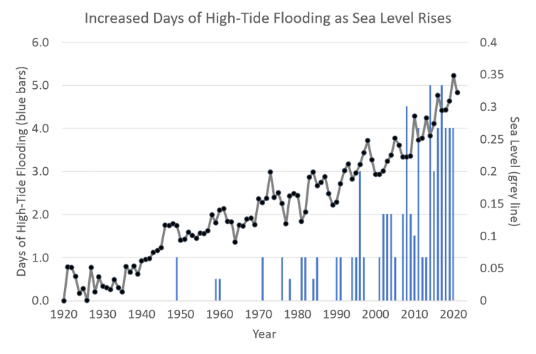
The frequency of high-tide flooding along the U.S. coasts has doubled since 2000, and it’s expected to increase five to 15 times more in the next 30 years, the National Oceanic and Atmospheric Administration warns in a new report released July 14, 2021.
I work with coastal communities in the northern Gulf of Mexico that are facing the risks of rising seas as they try to avoid preventable damages and costs, such as infrastructure failures and falling property values. Information like the NOAA report is critical to helping these communities succeed.
Last year, the U.S. averaged four days of high-tide flooding, but that number doesn’t tell the whole story – regionally, several areas saw far more. There were record-breaking numbers of high-tide flooding days in 2020 along the Gulf of Mexico and southeast Atlantic coasts. The city of Bay St. Louis, Mississippi, jumped from three days of high-tide flooding in 2000 to 22 days in 2020.

NOAA’s annual high-tide flooding report projects a national median of three to seven days of high-tide flooding this year, again with differences expected regionally. The western Gulf Coast, including Texas and Louisiana, is expected to see the most tidal flooding days, ranging between seven and 15 days. The northeast Atlantic is projected to have six to 11 days of high-tide flooding. The Pacific Coast is projected to be lower than the other regions.
Calling it ‘nuisance’ flooding overlooks damage
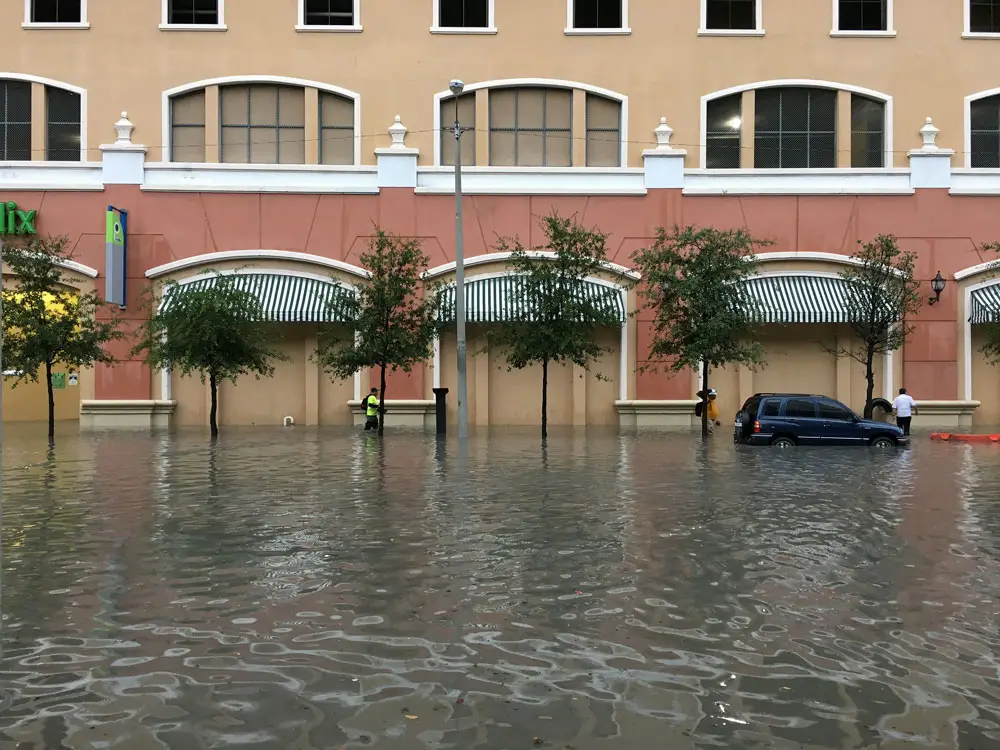
![]() High-tide flooding impedes the use of roads and increases wear and tear on stormwater and wastewater systems. The impact can seem minor, but as the frequency increases, these seemingly inconvenient flood days can have long-lasting impacts.
High-tide flooding impedes the use of roads and increases wear and tear on stormwater and wastewater systems. The impact can seem minor, but as the frequency increases, these seemingly inconvenient flood days can have long-lasting impacts.
Already, areas at risk from sea level rise have seen decreases in property values, particularly where cities and homeowners haven’t taken steps to increase flood resilience. Insurance premiums are beginning to increase to reflect actual risk, and bond ratings are increasingly being tied to the resilience efforts of communities.
Flooded roadways can create dangerous situations where first responders struggle to safely reach those in need. Businesses get fewer visitors and feel the loss in depressed revenues. The more often this happens, the more it ripples through coastal economies. It can affect tax revenues and erode community ties.
Sea level rise disproportionately impacts poorer, marginalized communities, and the impact of high-tide flooding has been no exception. People living in some of the most underserved coastal communities are facing increases in their insurance premiums because of the flood and storm risks, sometimes with more than 90% of the insurance policies in a single ZIP code projected to increase.
Ways to reduce the threat of high-tide flooding
NOAA’s projections provide valuable foresight that can help local governments, property owners and other coastal stakeholders to act before the water rises.
Communities can upgrade their infrastructure, such as raising roadways and installing backflow preventers in stormwater systems, and modify building standards such as increasing freeboard, the distance required between the first floor and base flood level, or designating base flood elevations outside of current FEMA flood zones to help prepare communities to withstand higher seas. Communities can also work with nature to preserve and restore coastal habitats that provide natural flood protection such as marshes and barrier islands.
Pensacola, Florida, is one example of a city being proactive. It recently completed a sea level rise vulnerability analysis to determine where high-tide flooding will begin to strain infrastructure, low-income neighborhoods, economic hot spots and critical facilities. The city was able to recommend where to prioritize action and what kind of action will be necessary to keep high-tide flooding from being costly or as damaging.
The message from the new report is clear: High-tide flooding and other more severe types of flooding have already increased with sea level rise and are expected to accelerate in the coming years. Communities have an opportunity to act now to reduce the impacts.
Residents in any coastal community can reach out to their local governments to encourage forward thinking. For more information on how to get involved in coastal resilience, almost all coastal and Great Lakes states have a coastal resilience specialist within their Sea Grant programs. Each regional NOAA Office for Coastal Management can offer guidance on how to get involved, as well.
![]()
Renee Collini is a Coastal Climate Resilience Specialist at Mississippi State University
The Conversation arose out of deep-seated concerns for the fading quality of our public discourse and recognition of the vital role that academic experts could play in the public arena. Information has always been essential to democracy. It’s a societal good, like clean water. But many now find it difficult to put their trust in the media and experts who have spent years researching a topic. Instead, they listen to those who have the loudest voices. Those uninformed views are amplified by social media networks that reward those who spark outrage instead of insight or thoughtful discussion. The Conversation U.S. seeks to be part of the solution to this problem, to raise up the voices of true experts and to make their knowledge available to everyone. ![]()


Jimbo99 says
Really the only flooding that I’ve seen around here is the High Bridge area and back roads of the Tomoka loop that gets the river to flood those roads. Maybe that affects the intracoastal neighborhoods more, but it’s really not as big an issue West of I-95 ? There are canals on the West side of I-95. I can relate though I lived in NMB, FL and periodically the Greynolds Park area nearer the intracoastal there did have flooding issues. The flash thunderstorms were a bigger problem than the hurricanes & full moon tides there. Which is pretty much what we see here in Flagler county too. The rains around July 4th filled the swales, but not to the point of flooding dwellings. 5-15X would end up doing that though.
Dennis C Rathsam says
I guess we wont be going swimming, or eating at all those good resturants in Flagler Beach.
Lunar Man says
The Moon is in its 19 year “WOBBLE” cycle. And according to scientist , we will see the OCEANS rise 5 to 15 times its normal levels. And that’s not just a temporary situation. It means by 2038 the ocean level in Flagler Beach will be OVER A1A and down into the residential areas. Now, add on the surge from monthly Full Moons and God help us, HURRICANE SURGES and residence and businesses on the West side of the Flagler Bridge will be UNDER WATER by 12ft…….. Time to sell !
Steve says
So mara lago will be six feet under along with orange beach ball 45
Robby Robert says
Wobble my ass. Can’t get my boat off the lift without dragging bottom this summer… My well went dry and the grass in this town is looking skinny.. You gotta quit using Alfred E. Neuman Pot.. LOL!!!
Richard says
AHHHH! Good news finally, my property on S Daytona will become beachfront property sooner than I had planned. Its value just increased by 25%. Thank you!