


Imagine an interactive site where every housing development in Palm Coast, Flagler Beach, Bunnell and Flagler County, past, present, and future, is mapped out and available at a click. Every development’s details–number of homes, apartment units, commercial or industrial square footage–is listed, often with illustrations and links. Developers are listed. So are construction dates or projected buildouts.
That map is now public and free to use, if not quite as free to its creator, who’s paying for it.
“It will become kind of a universal reference tool for the area,” Don Tobin says, “and of course, it’s a highly targeted audience, right? So that makes it very valuable.”
Since starting his GoToby.com website 20 years ago as the local bible for all things real estate in Flagler County, Tobin (Toby to everyone who knows him) has been data-driven, collecting and filling spreadsheets to document his reporting on the local housing industry.
Four years ago, he started mapping some of that data to ease his own access to the numbers and have a clearer geographic idea of where everything is.
“I’ve got literally hundreds of spreadsheets developed over the years, number of building permits, multi-family, duplex, single family,” Tonin said, “all of this data and trying to relate it down to the community level turned out to be pretty useful, often, so that’s why I developed a map for my own use. Then I realized how powerful it was, and I thought, I need to push this out.”
After some trial and error with a couple of platforms, he settled on Atlist, which interfaces with Google Maps, makes it easy to populate with data and allows for embedding on different sites (as you can see below). Try it:
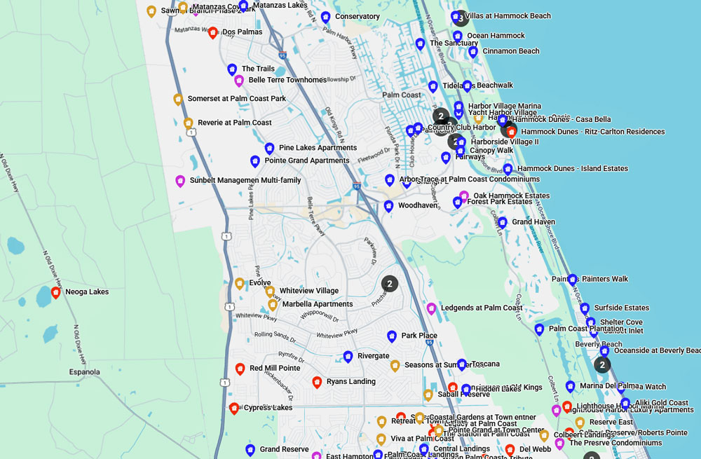
Tobin published the map at GoToby on Sept. 8 with a straightforward introduction: “Questions often arise, such as the location of new communities like Veranda Bay, the number of homes in established neighborhoods such as Grand Haven, and where apartments or other housing options can be found. The Flagler County Residential Development Map is the answer.”
None of the local governments have a map like it. Nor do associations like the home builders or the realtors.
Ever wondered what major developments have been approved for Palm Coast’s so-called “westward expansion”? A couple of them were a decade and a half ago: Neoga Lakes, 7,000 homes, more than 2 million square feet of commercial, civic and office space. Or Old Brick Township, 5,000 homes, over a million square feet of commercial and industrial space. Both are easy to find on the map, with those details.
Also on the map: The Reserve at Haw Creek, the colossal, 6,100-home development the Bunnell City Commission, after first killing it in the face of staunch public opposition then undergoing a remarkable metamorphosis, just approved for west and south of the city. The Resrve appears with an illustration of its geographic boundaries, though the item has yet to be updated to indicate “approval” as opposed to pending approval. (The developer is hunting for a central location in Bunnell to put up a welcome center in the style of ITT’s old welcome center in the nascent days of Palm Coast.)
Developments with as few as 10 homes are included. But infill, single-lot developments such as ITT’s in Palm Coast are not.
Tobin broke down the markers according to “established developments” like Grand Haven, Park Place, Grand Landings and so on, projects “under active development,” planned or entitled developments, and proposed developments that have not yet been entitled.

It’s a work in progress, intended–like development in the county–to be continuously in progress. At 82, Tobin continues to put in the hours: the map took hundreds of hours of work in addition to his other commitments.
But updates are part of the map’s value. The map’s icon for Veranda Bay, for example, the development along John Anderson Highway, includes a map of the ongoing, 122-home phase, but will likely be updated this month as Veranda Bay appears before the city’s planning board and city commission for approval of its next steps as it inches its way toward a 2,400-unit development over the next decades.
It’s not cheap for Tobin to host it. Atlist charges a base fee for a certain number of views, then each additional view costs a fraction of a penny. It sounds small, but it can add up quickly. “My intention is really to go to builders realtors, developers, people that are proud of the industry to support the map internally.
Annamaria Long, executive officer of the Flagler Home Builders Association–who’s often worked with Tobin on his “Real Estate Matters” radio show on WNZF–joked that all that knowledge that had accumulated in Tobin was finally extracted and put on a map.
“While this map is especially useful for those in certain professions, I think it is also really helpful to the general public,” Long said. “We often see signs pop up around town or hear about a development at a municipal meeting. This map allows a user to click on the name they heard or saw and get background information. Some of the developments have been approved since the early 2000s and dirt still hasn’t been moved, others were approved and got dirt moving rather quickly. The map provides not only information but perspective that one otherwise couldn’t find without hundreds of hours of research.”
It’s not inconceivable–if not desirable–that over time local elected officials will bookmark the map on their laptops for the kind of quick, comprehensive and cross-county reference they can look up during their meetings, for information not even their own staffs could produce as readily, or as comprehensively, across municipal boundaries.
In the near future, Tobin is exploring adding features, such as a search feature that would show current homes for sale in the local market.


Using common sense says
Does this site also list the back door deals, behind closed door meetings, quid pro quo deals, special interest “contributions”, and special deals and incentives residents would never get? Asking for a friend.
James says
Sad.
Just an opinion.
BMW says
Thank you, Mr. Tobin.
Sherry says
Incredibly well done! Hopefully this map will help the decision makers in Flagler country understand why so many feel that “Over Development” is happening all around them.
Gail says
Well done, Toby. I’ve hoped we had a site like this to easily find out what’s going on with development here, there’s so many new projects already started and more on the way I can’t keep up. I hope they remember what attracted us all here in the first place. Keep some trees, please.
PDE says
Toby’s map needs a little work.
For example, when you click on a specific development from the drop down list on the left side of the map, the development description is partially hidden behind the drop down list itself.
When you click on the development description, it needs to pop up in front of the drop down list on the screen, not behind it.
PDE says
Full Disclosure Update: I left a voice mail for Toby about this and he responded promptly.
He told me that if you make the map smaller by clicking on the minus button and then move the map to the right, you are able to read the individual development details in their text box.
Just thought I should update.
And yes, I’m sure it was a huge project to complete, nice job Toby.
Laurel says
“In the near future, Tobin is exploring adding features, such as a search feature that would show current homes for sale in the local market” Ummm, Zillow?
So, are you also keeping data on wildlife habitat disappearing, as well as the wildlife itself? How about the less wealthy being pushed out of their long time homes? That could be useful too.
Jay Gardner says
Toby is a wealth of information. I always said if you want to know what’s happening in our county just call Toby as he likely knows. He is a true asset to Flagler County. If you want to hear Real Estate stats he has a radio show and pod cast called Real Estate Matters on WNZF News Radio.
Susan Romanello says
Great job Toby! You are a wealth of information and always have been. Thank you for all the information. Hopefully the building will slow down at some point as the infrastructure just can’t handle this all. But thank you!
Concerned says
Need to bring up why the City got stuck with paying for the utilities going up Old Kings South when it was said the developers were paying for it ? Oh it’s true ! Is this why everything went up so much !