


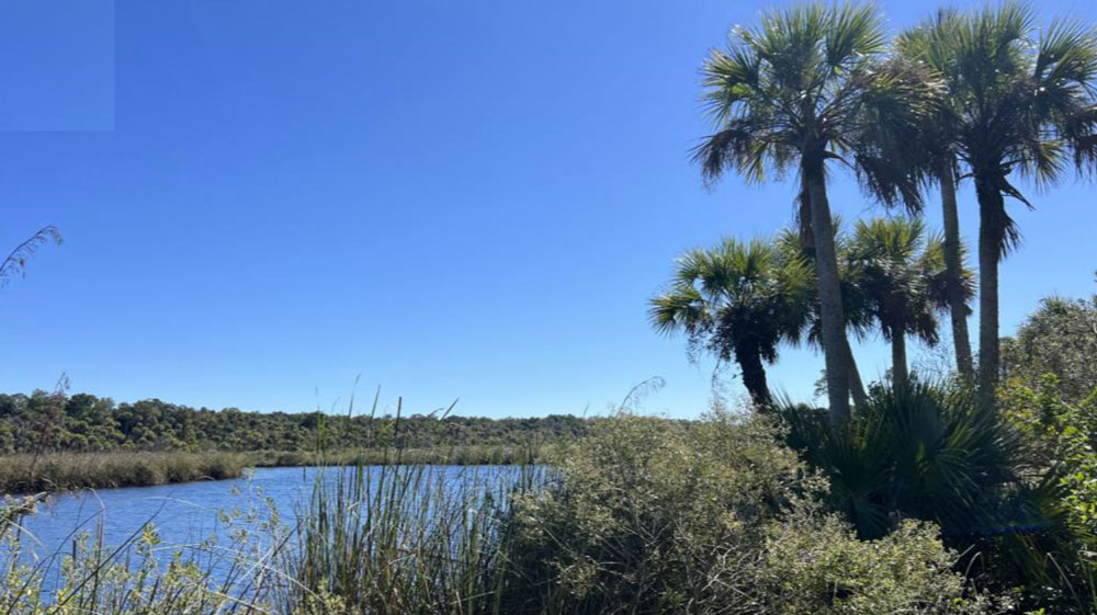
Flagler County is working toward adding Bulow Creek Headwaters Regional Park to its inventory of environmental and protected treasures.
That day may not happen until the early 2030s. But last week the public and several county commissioners were briefed by the park designers on the latest plan for what will be an expanse of protected land almost as large as the Princess Place Preserve, stretching south of State Road 100, east of Old Kings Road and west of what is now Flagler Beach and the future Summertown development.
The park is currently a 1,160-acre preserve. If the county has its way, with the planned purchase of 153 acres from the Summertown developer, it will be a 1,300-acre park that will connect trails north to the pedestrian bridge, the future Eco-tourism visitor center, Graham Swamp and the Lehigh Trail, and south to Bulow State Park, continuing into Volusia County. It will have a picnic area, and will provide a fishing pier and a launching dock for kayaks and canoes into the headwaters of Bulow Creek. The overwhelming majority of the acreage is wetlands.
The $1.5 million planning portion of the project is nearing completion. That bill was paid by the Florida Department of Transportation. The designing and permitting phase is next. The design phase is part of the planning phase, and is paid for, Flagler County Project Manager Amy Stroger said. But it will take many millions of dollars to build the trails and transform the land into a park. That money has yet to be secured, though various grants are being pursued. Stroger was hesitant to cite an actual figure, as those estimates are still in preparation.
But it’ll be costly. “We don’t know yet what will move forward and what won’t, but we will likely have to phase the construction,” Stroger said, “because it will be more than what a typical grant would cover. So we will likely phase it into different elements. For example, we might start with the north-south trail and the trailhead, and then we might build on that.” The trailhead and the trail alone would be around $8 million, based on very preliminary estimates.
“I think it’s awesome. The pedestrian, bicyclist access, the connectivity of the trails,” said County Commissioner Andy Dance following a presentation by the designers. County Commissioners Kim Carney and Pam Richardson also attended. The completed design will be submitted to the County Commission in April. The design may have cost estimates for the construction.
The Department of Transportation, in a separate project, is paying for a trailhead and parking area at the foot of the bridge.
C. Elizabeth Manley led the planning phase for Kimley Horn, the engineering company. That phase included two public workshops–the Feb. 3 session was the second–where residents made suggestions or objections to what had been planned until then. One of the objections, for example, was that three access points into the creek may have been too many. That was reduced to two structures. The launch pad accommodates two simultaneous launches. No motorized boats are allowed.
The project’s goals, as presented by Kimley Horn, are for the park to manage the land as a preserve, to “celebrate the area’s cultural history,” support local tourism and become a destination for passive recreation. Passive recreation is defined as non-competitive, non-intrusive leisure activities such as biking, kayaking, picnicking, bird-watching, hiking, and generally doing things that don’t inordinately intrude on surrounding nature, though the sheer presence of human beings in nature is by definition an intrusion–as are the trails, picnic area, trailhead and 36-space parking lot to be built.
Paved trails will be bike-friendly. The 2.8-mile north-south trail on the far western side of the park, connecting the pedestrian bridge to Old Kings Road to the south, will be paved. Biking will not be promoted on the non-paved trails. Until state law changes, Dance said, electric bikes, or ebikes, will be treated like non-motorized bicycles. “We can restrict the different types of bikes,” he said. For example, the county can restrict ebikes to Class 2 bikes, which have motors that top out at a certain speed, and are not considered off-road bikes.
Kimley Horn refers to that future construction as “improvements.” Dance and Manley recognized the misnomer.
“You can’t improve this. It’s just providing access, so the residents have access to the park,” Dance said.
That’s why, Manley said, the plan is driven by certain principles, such as “maintaining natural resources and keeping this as much of a preserve as possible,” and why new elements to be built in the preserve are where they are. “That is why the north south trail is so far to the west. It’s to minimize impacts and separation of our wetland areas,” Manley said. It was a concerted effort to do just that, avoiding disruptions to the wildlife corridor further east.
The trail is as close to the western edge of the future park as possible while still hugging the wetlands to create the experience of being in them. The trail will be similar to the one built through wetlands from Graham Swamp to the pedestrian bridge on 100, with certain bridge-like spots that give the hiker or biker the sense of being suspended above the wetlands, or at least wading through them, dryly.
“We were very mindful to allow access and allow experience with minimal impact as possible,” Manley said. “That’s what the county wanted, that’s what we want, but it’s also what’s mandated by the permitting requirements of the funding.” Planners and local governments must adhere to protection standards to secure certain types of grants.
All the unpaved trails, for example, are on existing land management paths, so there will be no additional disruptions. The land managers will continue to use the trails for access. Now the public will be able to benefit as well. The picnic area will not be carved out of nature. All that acreage was already platted for the Polo Club, until the county acquired the land.
“We also were very mindful to continue the connections between the creek edge and the uplands,” Manley said. “That’s really important in terms of wildlife corridors and water quality issues. And so that’s why we have everything to the outside as well, to maintain those natural drainage flows to the creek and to just not disrupt any water quality issues–to actually enhance water quality.”
![]()


David Meeks says
GOOD!!!! Lets get this done. We NEED this to get away from all the rapid urban building the county is having & the influx of people.
Leave me alone & let me enjoy what’s left of nature!
Dusty says
Finally some good news now if we could get a YMCA nearby that would be good too.