


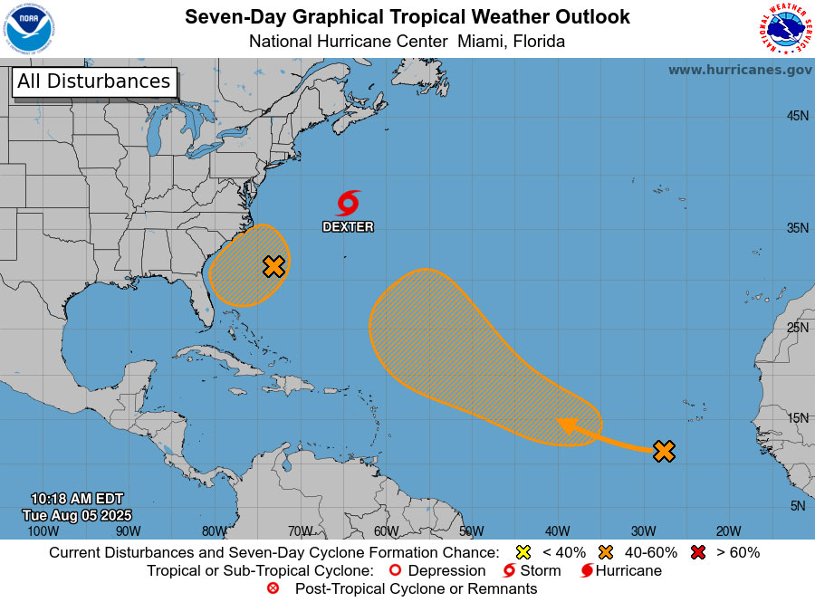
The National Hurricane Center is monitoring two weather systems for potential tropical development over the next seven days, including one near the southeast Atlantic coast. This system now has a 40 percent chance of tropical cyclone formation on Friday or Saturday, up from 30 percent.
Regardless of how this system evolves, the National Weather Service in Jacksonville said this morning, an influx of tropical moisture and coastal convergence could increase flood risk for coastal areas Friday into Saturday. The Weather Prediction Center (WPC) has a Marginal Risk (level 1 out of 4) of flooding rainfall for coastal locations.
Another system, currently in the eastern, tropical Atlantic, has a 50 percent chance of tropical storm formation in seven days. The American forecasting model shows that weather system remaining disorganized as it crosses the Atlantic toward the Lower Antilles by Monday, then developing further into a more organized storm as it swerves north by midweek next week, and heads for the North Carolina shore. See the storm’s forecast from today through Aug. 21 in the animation below.
This week, onshore winds and building easterly swells will maintain at least a moderate rip current risk for local beaches, potentially increasing to high risk for some locations by the weekend with rough surf. Meanwhile, the National Weather Service is forecasting a strong potential for strong thunderstorms this afternoon and evening along the I-95 corridor, from Coastal Georgia down to Palm Coast and Flagler County, with possible wind gusts of up to 50 mph, heavy downpours, localized flooding and frequent lightning. The timing for the likeliest storms would be between 2 and 8 p.m. See the Jacksonville-NWS’s daily weather briefing here.
Temperatures will be near normal this week but will again be above normal next week. NWS recommends using the next few days to monitor official weather forecasts, review home and business emergency plans, and refresh emergency supplies, if necessary.
The hurricane center had predicted a 60 percent chance of an above-normal hurricane season, with a range of 13 to 19 named storms of winds of 39 mph or higher–whether tropical storms of hurricanes. There have been four named storms so far, with Tropical Storm Dexter currently swirling south of Nova Scotia, and heading northeast, away from the North American land mass.
![]()
The forecast through Aug. 21 (Tropical Tidbits):

The European Model:


Katie says
Florida don’t like woke it means you care for others. Pray Mexico will send help if we need it! Took fema over 72 hours to even acknowledge there was a flood in Texas (you know the recent one a bunch of humans died in), Mexican authorities were already on site rescuing people! Let that sink in!!! Gutting the government to give rich people more money solves NOTHING and most often exacerbates existing problems!! You all see the cdc and epa pushing misinformation recently isn’t that sad and sick?! Now firing the statistician cause his forced recession caused a recession and he needs to point a finger at somebody! What a horrible stain.
JimboXYZ says
These 3 seem harmless enough for the cones if doom. But it will most likely get us to September thru November for the heaviest activity. Perhaps at that point of 2025, the Gulf of Whatever anyone wants to call it becomes the originating storms.
Heading the comments off ahead of the flood of them ? Let’s not blame FEMA, Trump or NOAA, not like any of them can do a thing about what is a slam dunk for hurricane season. Funny, blaming Trump for any of that, yet Ft Myers & every city that got wiped out was with more funding under Biden-Harris, the Bidenomics of Inflation created record storm damages. Tariffs will do the same for Trump’s 2nd term ? And the kicker, FEMA was spending 100’s of millions on NGO’s & illegals that crossed the border. FEMA is slower & weaker ? Why is that ? The budget swelled, new hires, more technology. A Green New Deal and nothing has changed. Maybe they need to apply that money to repair post storms rather than house illegals ? At the end of the day, every POTUS has had storms, fires, Earthquakes/Tsunami’s, oil spills, tornadoes, floods under their watch. The world’s population just jeeps growing, that’s a couple of people bringing more lives into the misery of it all. Look around your own home, look at your spouse & children, the overutilization for pollution. Maybe own your own hand or rather reproductive system for individual responsibility for exacerbating the issues ? Maybe it’s that 10 mpg pickup truck or muscle car that wastes fuel/energy. Maybe it’s that $ 130K Tesla for it’s strain on the grid for the EV battery lifestyle. Trying to avoid paying gasoline tax for the road that everyone has to repave eventually. There’s more. We just got done doubling the capacity of one of the STF’s. That capacity is the growth, a flawed vision/reimagine of 2050. That’s where we are, no solutions & just getting worse for quality of life. That STF wasn’t any improvement, it was a lame & expensive attempt to keep up with the status quo. There are going to be those amongst us all that perpetuate the next round of STF additions.
Larry says
Flagler County Commissioners need to step up to the plate and agree on a long term beach renourishment plan. The plan that was being proposed was good and should be agreed upon next chance they get, before it’s too late. Let’s hope we make it through this season.
Travis says
The science information that this regime has hidden and blocked shows it’s way worse than you think and will happen far faster than expected!!! But keep believing your orange pedophile haha!
Burn baby burn says
republicans always try to put the responsibility on individuals but the reality is it’s takes regulation! Single use plastic is a cancer that’s literally already in your brain! Microplastics cause many cancers and tumors and totally destroy ecosystems! PFAs ? orange stain thinks are fine even though they cause cancer! They gutted the EPA and then made them release misinformation! So we don’t test for much! Who thinks current society will make it to 2050? I certainly do not! Do you all want this fascist oligarchy to continue? I say start over and put people over money!
Problem not solved says
There is an entire generation of people that won’t get out of the way and do not understand the problems and issues of today! There is no going back!
Economic terror says
hurricanes are on average getting stronger , more destructive and more costly. Your insurance company knows this! Your banana republic has banned the term and hidden the data! no presidents are not the same! One is an orange pedophile posing as a president! Keep gutting the programs that help your fellow man to enrich the richest 300 people! Find out when it matters!
Over 1 million lay offs this year alone with the weakest job numbers since 2008! When is this forced recession supposed to help people again hahaha?!! What happened to critical thinking, class, honesty, and most importantly empathy? This trumpflation is out of control! Oh and the fed should only lower interest rates when inflation is declining and forecast indicates it will continue to decline.look it up!! That is not where we are ! New tarrifs mean new inflation! Orange terror will terrorize the last adult in the room (zero accountability!) but cutting rates early will not help and only lead to even more inflation! We would be zimbobwified within a year or so! We circled the drain! Awful pathetic we’re here , but people were warned!