Last Updated: Saturday, 7:41 a.m. For more up to date reports, go here.
Sunday, 7:15 a.m.–Tropical Storm Ian, intensifying slightly slightly overnight to 50 miles per hour, is expected to become Hurricane Ian either later today or early Monday.
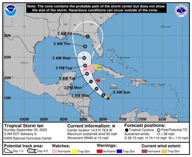
Ian has been moving at 12 miles per hour west northwest, and was still in the southern portion of the Caribbean Sea this morning. It is expected to make a turn to the north today is expected to forecast to turn northwestward later today and approach the far western part of Cuba Monday night or early Tuesday morning as a major, Category 3 hurricane with winds of 111 miles per hour or more.
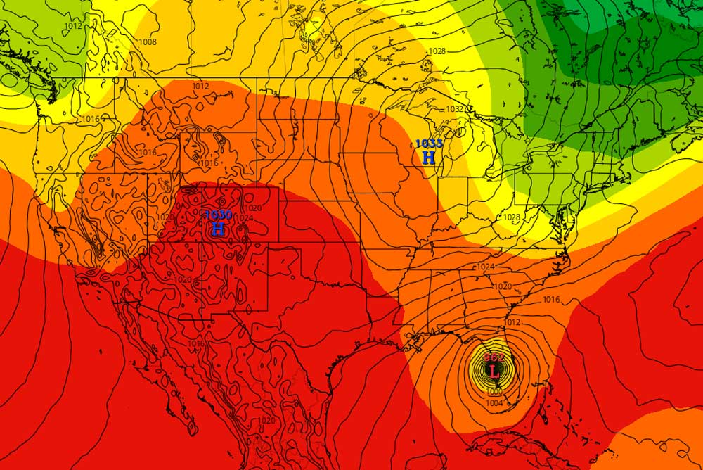
The various models are in largely in agreement about Ian’s path over the next three days: a slight arc around western Cuba and into the Gulf of Mexico. The storm is arcing around another low-pressure weather system much further east in the Atlantic. But the models diverge beyond that. The National Hurricane Center and the National Weather Center in Jacksonville therefore stress that path projections for the middle and late parts of next week remain uncertain. So does the area of the storm’s potential landfall in Florida.
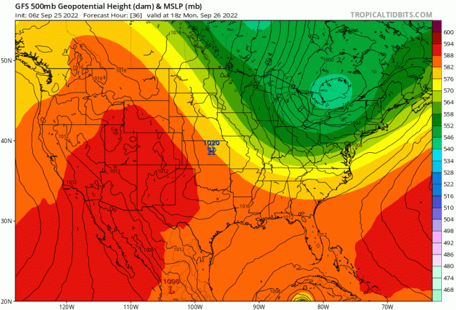
For example, the American Global Forecast System has the storm cutting a more northerly path through the Gulf after crossing Cuba, and making landfall in the center of the Florida Panhandle, roughly in the area south of Tallahassee early Friday, like this:
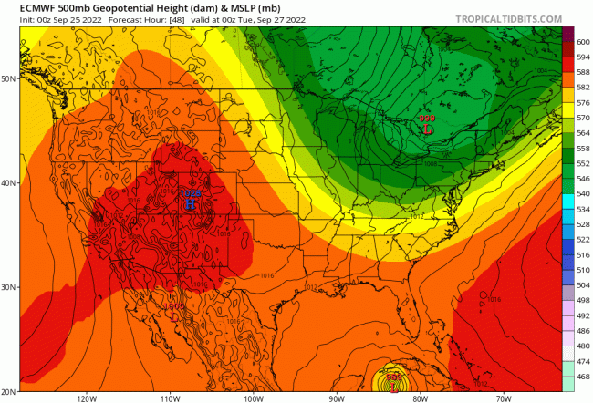
The often highly accurate European forecast model known as ECMFF (European Centre for Medium-Range Weather Forecasts) draws a different, more easterly path. Ian would cross the western portion of Cuba as a hurricane around 8 a.m. on Tuesday, then make a more pronounced easterly bend toward Tampa Bay, where it would make landfall Wednesday evening around 8 p.m. Ian would then continue inland, crossing Orlando and Central Florida early the morning of Friday, Sept. 30. It would rapidly move northeast toward Jacksonville, or just west of Jacksonville. That model would result in more severe impacts to Flagler County. Click on the image below to see it in action:
The National Hurricane Center typically splits the difference between principal models, so currently it has Ian’s path curving past Tampa Bay, offshore, and striking Florida in the Big Bend area at 2 a.m. Friday, by which time it will have degraded from a major hurricane to a lesser but still dangerous hurricane.
In NHC’s own words, which also refers to Britain’s forecasting model and to its own (HWRF): “The UKMET and ECMWF models continue to hold firm along the eastern side of the guidance and show a track into west-central Florida, while the GFS and HWRF remain one the western side, taking the Ian into the central or western Florida panhandle. The updated NHC track continues to split these differences and remains closest to the TVCA multi-model consensus, and the latest GFS ensemble mean.” (You can keep up with all those acronyms here.)
“It cannot be overstated that significant uncertainty remains in Ian’s long-range prediction,” NHC stresses.
There is, however, a 90 percent chance that Ian will intensify into a major hurricane over the next 48 hours. Intensity will decrease only on the approach of the Florida coast, should the storm follow the NHC’s consensus forecast and strike Florida further north. “Despite the reduction in intensity,” NHC warns, “Ian is likely to have an expanding wind field and will be slowing down by that time, which will have the potential to produce significant wind and storm surge impacts. Users are urged to not focus on specific forecast intensities in the 4- and 5-day forecasts and instead focus on the potential hazards Ian may produce across portions of Florida.”
Here’s NHC’s latest consensus path as of 5 a.m. Sunday:
Previous developments are below.
![]()
Hermine Becomes Ian as Storm Now Projected to Intensify and Strike Florida From West
Saturday, 6 p.m.–There was some slightly better news and worse news for Floridians, depending on where they live, when the National Hurricane Center released its evening report on Tropical Storm Ian: the storm is shifting slightly west, according to the center’s consensus model. That track would largely spare Tampa Bay and Central Florida, including Flagler County, of the most damaging impacts. But the track now has the storm heading for Florida’s Big Bend.
According to the European forecast model, which has tended to be among the better predictors of storm tracks, the storm would not so much shift west as shear into the Tampa Bay area then cut its way up the coast, into the Big Bend area, before barreling through the middle of north Florida and into Georgia. That path would radiate plenty of rain and some wind to the east, including Flagler.
The NHC model as of Saturday evening had the storm making landfall further north the evening of Thursday. The European model has it making landfall further south Thursday morning around 8.
Ian’s maximum sustained winds on Saturday evening remained at 45 miles per hour. But the tropical storm was “expected to significantly strengthen over the next few days,” according to NHC, with “rapid intensification” toward hurricane status: “The NHC intensity forecast has been raised substantially through 96 [hours], and it now shows Ian reaching major hurricane strength by late Monday before it nears western Cuba.”
A major hurricane is Category 3 or higher. Category 3 means the hurricane packs winds of at least 111 miles per hour. “Ian is forecast to remain a major hurricane as it moves northward across the eastern Gulf of Mexico and approaches Florida,” NHC’s latest bulletin states. “Environmental conditions could become less favorable late in the period due to southerly shear associated with the aforementioned trough, but Ian is expected to remain a large and powerful hurricane through the period.”
“Regardless of Ian’s exact track,” the hurricane center cautions, “there is a risk of dangerous storm surge, hurricane-force winds, and heavy rainfall along the west coast of Florida and the Florida Panhandle by the middle of next week, and residents in Florida should ensure they have their hurricane plan in place, follow any advice given by local officials, and closely monitor updates to the forecast.”
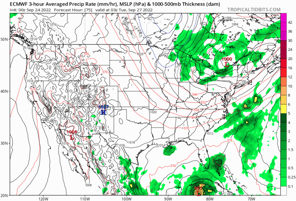
The earlier European model’s track:
![]()
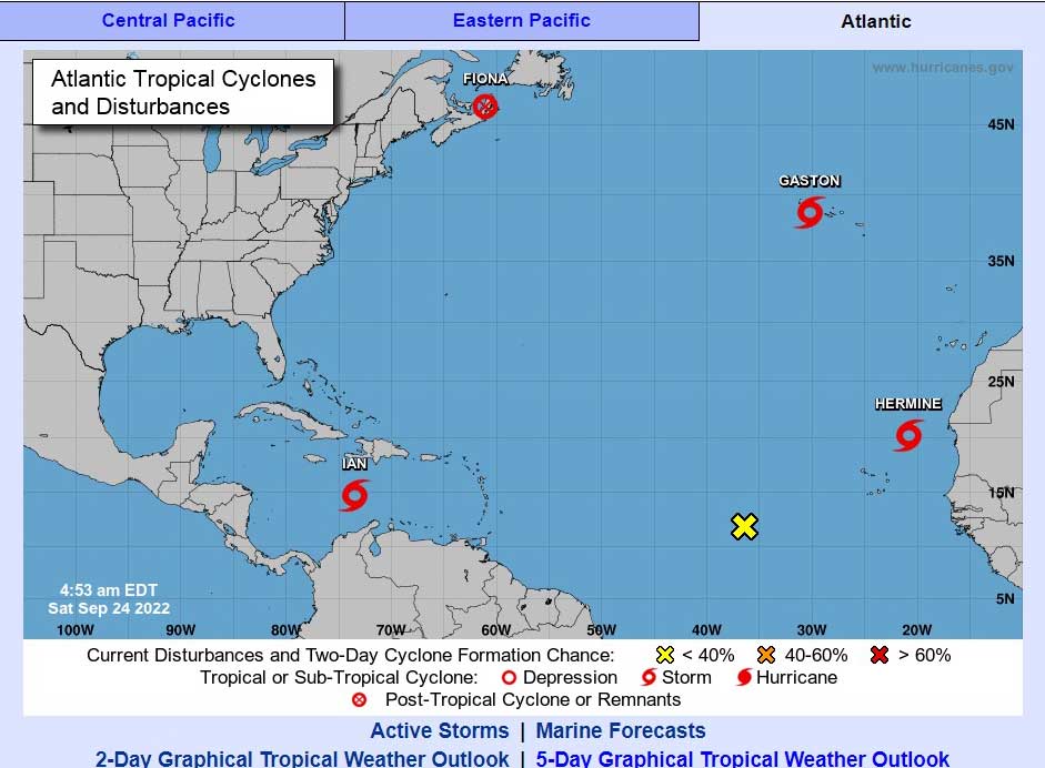
Saturday, 8 a.m.–Which is it? Ian or Hermine?
Taking a page from the Centers for Disease Control’s PR machine, which sent notoriously conflicting messages during the coronavirus pandemic, the National Hurricane Center early Saturday sowed confusion across news desks even as it sought to avoid it when it switched the sequence of named storms: Tropical Depression Nine would no longer be Hermine. That name was assigned to a developing tropical storm off the western coast of Africa. What would have been Tropical Storm Hermine this morning was renamed Tropical Storm Ian.
Technically, the Hermine off the coast of Africa, which is expected to degrade into a depression, ostensibly had become a tropical storm just ahead of the storm in the Caribbean, supposedly beating it to the name. But that gave the National Hurricane Center the justification to avoid confusion between two Hermines. Hurricane Hermine had developed in 2016 and struck Florida. NHC did not want a Hermine I and Hermine II so close to each other. Inexplicably–considering a surfeit of names available–the list of named storms repeats every six years.
Meanwhile Hermine Ian by Saturday morning had developed into a tropical storm, as expected, and was due to become a hurricane by Monday morning, and a major hurricane (Category 3 or more) by Wednesday morning. Its path is less certain after Tuesday, but the current cone of probability has Ian making a wide arc around the eastern Caribbean, passing over the easternmost portion of Cuba on Tuesday, then heading for Tampa Bay by Thursday morning, where it would make landfall.
p
If that path continues, it would be the most violent storm to make landfall on the Florida Peninsula since Hurricane Michael in 2018. Hurricane Michael turned into a Category 5 hurricane before making landfall in the Panhandle. But it did so in a more sparsely inhabited region.
This morning, according to the National Hurricane Center, Tropical Storm Ian was producing maximum sustained winds of 45 miles per hour, was about 315 miles southeast of Kingston, Jamaica. A hurricane watch was in effect for the Cayman Islands and a tropical storm watch in effect for Jamaica.
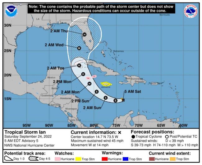
“On the forecast track,” an NHC bulletin stated at 5 a.m. Saturday, “the center of Ian is forecast to move across the central Caribbean Sea today, pass southwest of Jamaica on Sunday, and pass near or over the Cayman Islands Sunday night and early Monday. Ian will then approach western Cuba on Monday.” Heavy rain could begin in the southern Florida keys as early as Monday. Storm surge could raise water levels “by as much as 1 to 3 feet above normal tide levels” in the Caribbean. The storm is coinciding with a king tide cycle.
In Florida, Gov. Ron DeSantis declared a state of emergency for 24 counties currently expected to be in the path of Hurricane Ian. Flagler County is not on the list. State and local emergency management authorities are urging residents to use the relatively calm weekend to update disaster emergency kits and have a plan in place in case the storm affects the area.
In Flagler, “my gut tells me you’re going to see some kind of impact here in Flagler County,” Emergency Management Director Jonathan Lord said Friday morning. “It could be as small as a whole lot of rain, potentially up to five inches of rain. That compounded with the fact that we have those king tides is going to make it very hard for that water to leave. Which means we’re likely going to see even more localized flooding.
“But just to remind our residents and businesses, water in the roadway, water in your yard, is not a problem while it is flooding. It is not a life safety risk. We do highly recommend that you never drive through floodwaters but it is not necessarily an emergency if your street is flooded, or your swales are flooded or your front yard or your backyard is flooded. If it entered into your home, that’s a different story. But no matter what, please don’t try to those flooded waters. So that’s our best case scenario, I think for the coming week.”
Lord added: “This is a perfect weekend to go shopping. Update your supply kit. Make sure you have enough supplies. And I’d like to use one of the younger terms that people like to use these days to be able to be off the grid meaning you could survive without electricity or water for up to a week within your home.”
Lord has always stressed that the further out in a forecast, the likelier the changes. The path of the storm could be affected by small directional changes east or west.
“Still too early to determine any detailed impacts at this time as track uncertainty remains high for this storm after it passes the western portion of Cuba and enters the Eastern Gulf of Mexico early next week,” the National Weather Center in Jacksonville said this morning. The weather center issued the following briefing:
nws-jax-briefing (1)The state of emergency in Florida applies to the following counties:
- Brevard
- Broward
- Charlotte
- Collier
- DeSoto
- Glades
- Hardee
- Hendry
- Highlands
- Hillsborough
- Indian River
- Lee
- Manatee
- Martin
- Miami-Dade
- Monroe
- Okeechobee
- Osceola
- Palm Beach
- Pasco
- Pinellas
- Polk
- Sarasota
- St. Lucie
![]()




Leave a Reply