• Skip to primary navigation
  • Skip to main content
  • Skip to primary sidebar
MENUMENU
MENUMENU
  • Home
  • About
    • Contact Us
    • FlaglerLive Board of Directors
    • Comment Policy
    • Mission Statement
    • Our Values
    • Privacy Policy
  • Live Calendar
  • Submit Obituary
  • Submit an Event
  • Support FlaglerLive
  • Advertise on FlaglerLive (386) 503-3808
  • Search Results

FlaglerLive

No Bull, no Fluff, No Smudges

MENUMENU
  • Flagler
    • Flagler County Commission
    • Beverly Beach
    • Economic Development Council
    • Flagler History
    • Mondex/Daytona North
    • The Hammock
    • Tourist Development Council
  • Palm Coast
    • Palm Coast City Council
    • Palm Coast Crime
  • Bunnell
    • Bunnell City Commission
    • Bunnell Crime
  • Flagler Beach
    • Flagler Beach City Commission
    • Flagler Beach Crime
  • Cops/Courts
    • Circuit & County Court
    • Florida Supreme Court
    • Federal Courts
    • Flagler 911
    • Fire House
    • Flagler County Sheriff
    • Flagler Jail Bookings
    • Traffic Accidents
  • Rights & Liberties
    • Fourth Amendment
    • First Amendment
    • Privacy
    • Second Amendment
    • Seventh Amendment
    • Sixth Amendment
    • Sunshine Law
    • Third Amendment
    • Religion & Beliefs
    • Human Rights
    • Immigration
    • Labor Rights
    • 14th Amendment
    • Civil Rights
  • Schools
    • Adult Education
    • Belle Terre Elementary
    • Buddy Taylor Middle
    • Bunnell Elementary
    • Charter Schools
    • Daytona State College
    • Flagler County School Board
    • Flagler Palm Coast High School
    • Higher Education
    • Imagine School
    • Indian Trails Middle
    • Matanzas High School
    • Old Kings Elementary
    • Rymfire Elementary
    • Stetson University
    • Wadsworth Elementary
    • University of Florida/Florida State
  • Economy
    • Jobs & Unemployment
    • Business & Economy
    • Development & Sprawl
    • Leisure & Tourism
    • Local Business
    • Local Media
    • Real Estate & Development
    • Taxes
  • Commentary
    • The Conversation
    • Pierre Tristam
    • Diane Roberts
    • Guest Columns
    • Byblos
    • Editor's Blog
  • Culture
    • African American Cultural Society
    • Arts in Palm Coast & Flagler
    • Books
    • City Repertory Theatre
    • Flagler Auditorium
    • Flagler Playhouse
    • Flagler Youth Orchestra
    • Jacksonville Symphony Orchestra
    • Palm Coast Arts Foundation
    • Special Events
  • Elections 2024
    • Amendments and Referendums
    • Presidential Election
    • Campaign Finance
    • City Elections
    • Congressional
    • Constitutionals
    • Courts
    • Governor
    • Polls
    • Voting Rights
  • Florida
    • Federal Politics
    • Florida History
    • Florida Legislature
    • Florida Legislature
    • Ron DeSantis
  • Health & Society
    • Flagler County Health Department
    • Ask the Doctor Column
    • Health Care
    • Health Care Business
    • Covid-19
    • Children and Families
    • Medicaid and Medicare
    • Mental Health
    • Poverty
    • Violence
  • All Else
    • Daily Briefing
    • Americana
    • Obituaries
    • News Briefs
    • Weather and Climate
    • Wildlife

Funnel Cloud Reported Just North of Marineland; Severe Storm Watch Until 11 PM

May 24, 2017 | FlaglerLive | 5 Comments

The next round of storms is taking shape. (NWS)

Last Updated: 3:35 p.m.

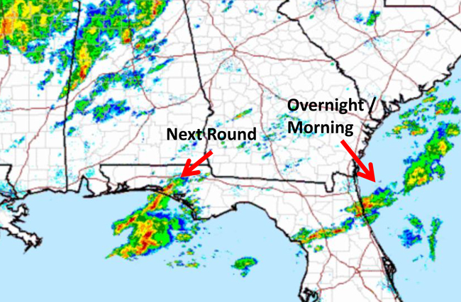
A small, brief funnel cloud touched down over the Intracoastal just north of Marineland this morning, scampered over A1A then dissolved over the ocean, says Bob Pickering, a weather specialist with Flagler County Emergency Management.


“It was very brief and it did not cause any damage,” Pickering said. The funnel cloud was part of a series of multiple significant weather advisories that have accompanied a recurring band of storms moving across the region.

The Flagler-Palm Coast area was under a tornado watch until 3 p.m. That has been replaced by a severe thunderstorm watch until 11 p.m. “The Storm Prediction Center is still predicting a low risk of the odd tornado,” Pickering said.

But so far today the storms have not caused serious damage. Some localized areas have received up to 2 inches of rain.

Earlier stories are below.


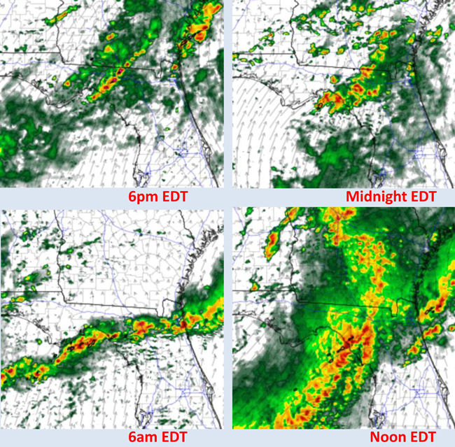
May 24, 10 a.m—Tornado Watch In Effect for Flagler-Palm Coast as NWS Predicts Heavy Rains and Winds

The National Weather Service’s Storm Prediction Center has increased the region’s severe weather threat to “enhanced,” with a tornado watch in effect for areas including all of Flagler County-Palm Coast until 3 p.m. today.

Storms are expected to roil through the area through the afternoon and into evening. An enhanced threat means potential for a significant severe weather event. The Storm Prediction Center cautions that watches and warnings are likely through the evening as conditions have developed in such a way as to create numerous thunderstorms and possible some supercells.

“Conditions will be favorable for damaging winds and isolated tornadoes,” the National Weather Service said in a briefing this morning.

The time of greatest threat in the area is from noon to 8 p.m. Potential threats are as follows:

• Wind gusts in excess of 60 mph are the primary threat.

• A few tornadoes likely.

• Hail up to 1 inch possible.

• Timing: Multiple Rounds of Thunderstorms through day and along front in the evening.

• Locally heavy rainfall with localized flooding and ponding on roadways.

• Storm motion: From the west southwest to the east northeast at 40 to 45 mph

• 2 to 4” of Rainfall forecast to occur with substantially higher amounts possible through tonight. Flagler County is in line for amounts closer to the 2 inch range or possibly less.

• Localized flooding may occur for portions of Northeast Florida through tonight.

Follow the latest at the National Weather Service’s Jacksonville Webpage: weather.gov/jax or its Facebook page: facebook.com/US.NationalWeatherService.Jacksonville.gov

Tuesday’s story is below.


Weather Service Cautions: Possibly Heavy to Severe Storms and Rainfall Late Tuesday and Wednesday

May 23–The National Weather Service cautioned this morning that the potential for heavy rainfall and severe storms was increasing for this region, starting late Tuesday night and through Wednesday. The worst of the weather currently is expected to affect regions further north, with the possibility of severe weather locally rising Wednesday.

If strong or severe storms develop, a science and operations officer at the National Weather Center’s Forecast Office said this morning, “the primary threat will be strong winds and heavy rainfall though hail and isolated tornadoes will be possible with the strongest storms.”

Computer models show the most activity in the Palm Coast-Flagler area Wednesday afternoon, with only scattered thunderstorms expected today between 1 and 4 p.m., and again for a couple of hours in early evening. The chance of thunderstorms or precipitations will hover at 50 percent starting at midnight and into Wednesday, and rising somewhat in early afternoon.

The closest tornado watch in effect Tuesday affects the Florida Panhandle, southwest Georgia and southeast Alabama.

The heavier storms could trigger wind gusts of 30 to 50 mph, with potentials for 2 to 4 inches of rain, possibly more in localized areas affected by more persistent activity. There is “some potential for hail or brief tornadoes with the strongest storms that occur, but considerable uncertainty on potential at this time, the National Weather Service states.

Rainfall is needed in Flagler, where the drought index has been in the 500 to 550 range, on a scale of 800, with 800 being the driest, and zero meaning the ground is saturated. The higher drought index led the county fire chief to declare a burn ban last month. It takes an inch of rain to lower the drought index by 100 points, so passing showers or thunderstorms are not enough to end drought conditions. Countywide in Flagler today, the average drought index is at 530, with the lowest readings in places at 468, and the highest readings close to 600.

severe weather maps
The National Weather Service’s computer models of expected activity over Northeast Florida in the next 36 hours.
Support FlaglerLive's End of Year Fundraiser
Thank you readers for getting us to--and past--our year-end fund-raising goal yet again. It’s a bracing way to mark our 15th year at FlaglerLive. Our donors are just a fraction of the 25,000 readers who seek us out for the best-reported, most timely, trustworthy, and independent local news site anywhere, without paywall. FlaglerLive is free. Fighting misinformation and keeping democracy in the sunshine 365/7/24 isn’t free. Take a brief moment, become a champion of fearless, enlightening journalism. Any amount helps. We’re a 501(c)(3) non-profit news organization. Donations are tax deductible.  
You may donate openly or anonymously.
We like Zeffy (no fees), but if you prefer to use PayPal, click here.

Reader Interactions

Comments

  1. Anonymous says

    May 24, 2017 at 7:22 am

    Everybody Hang on!!!

  2. blondee says

    May 24, 2017 at 2:36 pm

    This used to be pretty typical weather for Florida. Now it makes the headlines.

  3. FlaglerLive says

    May 24, 2017 at 3:04 pm

    Blondee, there have been over 30 tornado-related deaths so far this year in the country, already more than all of last year. Cautionary (rather than panicky) headlines are intended to help with a bit of extra awareness. The alternative may not be as useful.

  4. blondee says

    May 24, 2017 at 3:37 pm

    Fair enough. Although my point was really how atypical the heavy rains and t-storms have been recently.

  5. Brian says

    May 24, 2017 at 5:14 pm

    OH boy the Climate change folks are running amuck once more… the sky is falling.. in Russia…

Leave a Reply

Your email address will not be published. Required fields are marked *

This site uses Akismet to reduce spam. Learn how your comment data is processed.

  • Conner Bosch law attorneys lawyers offices palm coast flagler county
  • grand living realty
  • politis matovina attorneys for justice personal injury law auto truck accidents

Primary Sidebar

  • grand living realty
  • politis matovina attorneys for justice personal injury law auto truck accidents

Recent Comments

  • Shark on Deputy’s Son Jayden Jackson, 23, Sentenced to 5 Years in Prison for Hit-and-Run Death of Shaunta Cain
  • Me on Deputy’s Son Jayden Jackson, 23, Sentenced to 5 Years in Prison for Hit-and-Run Death of Shaunta Cain
  • A Republic if You can keep it on The Daily Cartoon and Live Briefing: Sunday, June 1, 2025
  • Steve Ward on Deputy’s Son Jayden Jackson, 23, Sentenced to 5 Years in Prison for Hit-and-Run Death of Shaunta Cain
  • Robjr on Deputy’s Son Jayden Jackson, 23, Sentenced to 5 Years in Prison for Hit-and-Run Death of Shaunta Cain
  • Gene L. on Deputy’s Son Jayden Jackson, 23, Sentenced to 5 Years in Prison for Hit-and-Run Death of Shaunta Cain
  • PeachesMcGee on Deputy’s Son Jayden Jackson, 23, Sentenced to 5 Years in Prison for Hit-and-Run Death of Shaunta Cain
  • Joe D on Why Your Electricity Bill Is So High
  • Deborah Coffey on Flagler County Will Buy 5.2-Acre Parcel on Intracoastal North of Hammock Dune Bridge for Preservation as Parkland
  • Leila on Flagler County’s Beach-Saving Plan All But Killed by Opposition to Sales Tax Increase Despite Last-Minute Switch
  • Deborah Coffey on GOP Bill Would Kick More Than 3 Million Off Food Stamps and Shift $14 Billion In Costs to States
  • Pierre Tristam on The Daily Cartoon and Live Briefing: Monday, June 2, 2025
  • Bo Peep on Flagler County Will Buy 5.2-Acre Parcel on Intracoastal North of Hammock Dune Bridge for Preservation as Parkland
  • T on Palm Coast’s Fire, Parks and Road Impact Fees Are About to Jump 90 to 160% as City Capitalizes Future on Development
  • Alice on GOP Bill Would Kick More Than 3 Million Off Food Stamps and Shift $14 Billion In Costs to States
  • Bill Boots on The Daily Cartoon and Live Briefing: Monday, June 2, 2025

Log in