Last Updated: 8:13 p.m.
Gov. Rick Scott on Sunday declared a state of emergency in Northwest Florida as a looming hurricane threatens to hammer the region in the middle of the week.
Scott said during a 6 p.m. news conference that he declared an emergency in 26 counties in the Panhandle and the Big Bend — generally areas surrounding Tallahassee — because of a storm in the Gulf of Mexico that became Tropical Storm Michael on Sunday.
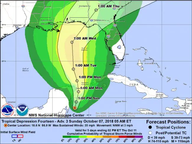
The National Hurricane Center said in a 5 p.m. advisory that its forecast “calls for Michael to become a hurricane in about 36 hours when the storm reaches the southeastern Gulf of Mexico. Additional strengthening is indicated through 72 hours when the storm is forecast to be near the northern Gulf coast.”
“Michael is forecast to be a hurricane when it reaches the northeastern Gulf Coast by mid-week, and the risk of dangerous storm surge, rainfall and wind impacts continues to increase,” the advisory said. “In addition, Michael is expected to affect portions of the Florida Gulf Coast that are especially vulnerable to storm surge, regardless of the storm’s exact track or intensity. Residents in these areas should monitor the progress of this system and follow any advice given by local officials.”
Scott said Michael could turn into a Category 2 storm with winds topping 100 mph and could bring damaging storm surge. “This storm will be life-threatening and extremely dangerous,” Scott said.
The National Weather Center in Jacksonville was not down-playing the effects on northeast Florida, including Flagler County. “Tropical Depression #14 has strengthened to Tropical Storm Michael,” the service’s Scott Cordero said at 4 p.m. “The system is east of the Mexican state of Quintana Roo off of the Mexico’s Yucatan Peninsula. Gradual strengthening and some increase in forward speed is forecast as the tropical cyclone moves northward into the Gulf of Mexico early this week. The official forecast still indicates a potential hurricane landfall along the Florida panhandle or Big Bend coast at hurricane strength midweek. By Wednesday night, the storm is forecast to be over interior Georgia. Tropical force winds may potentially occur from late Wednesday morning through the evening across the Suwanee Valley and across interior Southeast Georgia and immediately along the Georgia coast from late Wednesday afternoon into the pre-dawn hours Thursday morning.
“Well in advance of the approach of Tropical Storm Michael onshore winds will strengthen along the Atlantic coast Monday and Tuesday. These onshore winds will combine with an increasingly elevated astronomical tide due to the new moon to create at least minor coastal flooding during times of high tide, which could begin as early as Monday at the Atlantic coastal communities. Waves of showers and thunderstorms will increase in coverage by Tuesday, with local impacts continuing through at least Thursday morning before Tropical Storm Michael accelerates northeastward towards the Carolinas on Thursday.”
- High risk of rip currents through at least midweek.
- Threat for at least minor coastal flooding along the Atlantic beaches increases early this week as easterly winds strengthen well in advance of any direct impacts from TD #14.
- Waves of heavy rainfall and embedded thunderstorms beginning Tuesday and persisting through late Thursday, based on the latest official forecast from NHC.
- Still too early to specify potential rainfall amounts, timing of tropical storm force winds or threat for severe weather as outer rain bands move through our region on Wednesday and Thursday.
Nelson cautioned against social-media speculations on the storm’s impact.
He urged Floridians to get prepared for the storm and said he has activated 500 members of the Florida National Guard.
“Everybody’s got to get ready,” Scott said during the news conference at the state Emergency Operations Center in Tallahassee. “Don’t take a chance.”
The National Hurricane Center said the storm is predicted to lead to heavy rainfall and flash flooding in parts of western Cuba and the northeastern Yucatan Peninsula of Mexico before moving north in the Gulf.
With Scott running for U.S. Senate and Tallahassee Mayor Andrew Gillum running for governor, the threat of the storm quickly affected this fall’s elections. Gillum’s campaign said the Democrat was planning to return to Tallahassee on Sunday to focus on preparing the city for the storm. Gillum had planned to campaign Monday and Tuesday in South Florida.
Gillum’s mayoral office said he also “reached out to Governor Scott with an update on the city’s efforts.” That came after the two clashed in 2016 about the city’s response to Hurricane Hermine.
Tropical storm warnings were in effect Sunday morning for parts of Cuba and Mexico, and outer bands were expected to produce two to four inches of rain in the Florida Keys through Monday, the National Hurricane Center advisory said.
The advisory said the center of the storm was forecast to move near the northeastern tip of the Yucatan Peninsula on Monday morning and “then across the eastern Gulf of Mexico late Monday through Wednesday morning.” The storm could become a hurricane by Tuesday night or Wednesday.
-FlaglerLive and the News Service of Florida


Jeffrey says
Gonna be a big one!