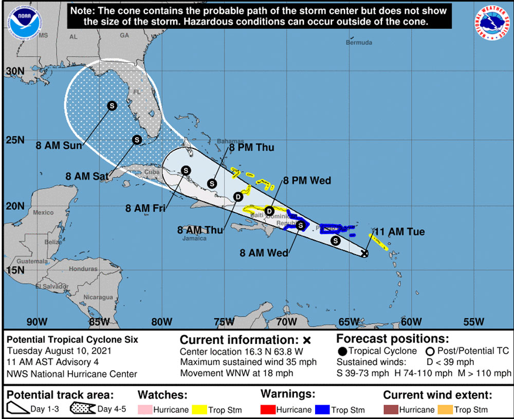
For now, Fred–the name, short for Frederick, means “peaceful ruler”–is some 350 miles southeast of Puerto Rico, with maximum sustained winds of 35 mph. But the National Hurricane Center gives it a 90 percent chance of becoming a tropical storm “later today or tonight,” as it passes near the U.S. Virgin Islands and Puerto Rico, and moving on up toward the Florida Peninsula from there.
That many days out, the track of the storm is extremely uncertain especially after it travels over the Dominican Republic and Haiti, where it’s expected to weaken before again picking up strength, assuming it stays over water by threading the needle between Cuba and the Antilles. If it skirts closer to, or over, the Cuban land mass on Thursday and Friday, it could again weaken. Because of that, “The remainder of the intensity forecast has lower confidence due to possible land interaction with Cuba,” the National Hurricane Center states.
Long-range forecasting, however, projects a very broad cone, and at the moment Flagler County is barely within that cone on the eastern edge of the storm, should it reach the northeastern area of the Gulf of Mexico by Sunday morning. The result locally would not be much different than it’s been for the past several weeks: periods of rain, the occasional thunderstorm, a few gusts of wind.
The European forecasting model, which tends to be the most accurate of the global models, has the storm reaching the Gulf a good distance southwest of Tampa Bay around 8 p.m. on Aug. 14, then moving toward the center of the Panhandle, well away from the Peninsula itself–and far away from Flagler, by 8 p.m. on Sunday. According to that track, it could be a bit messy in Tallahassee, but not much so locally. The National Hurricane Center projects no wind probabilities for Northeast Florida at the moment.
With all that in mind, county government this morning issued an advisory release. “August and September tend to be very active months for tropical depressions and storms, so it’s a good idea to be as prepared as possible,” said Emergency Management Director Jonathan Lord. “It is possible that we may see impacts in our area this weekend.”
Lord is asking businesses and residents to use Wednesday through Friday to ensure disaster supply kits are stocked, and to secure outdoor items that could become projectiles. If the “peaceful ruler” passes unnoticed, the next one could be more Poseidon-like.


Jimbo99 says
July TS/Hurricane threat happened, now the August TS/Hurricane is out there. Maybe we’ll get another one or more in September, October or even November. Last 90 days or so of this season are on tap. We’ll be OK, we all hope.