Scott Spradley is a long-time resident of Flagler Beach, a photographer who’s been documenting cityscapes and sunrises on a daily basis for years, and an attorney. He’s remaining on the Barrier Island for the duration of the storm, and is contributing a running account of Hurricane Ian’s local impacts as they develop.
![]()

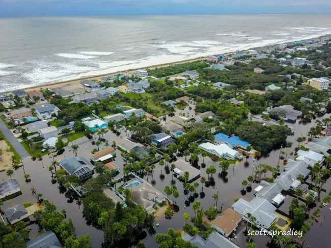
Friday, 9:30 a.m.— Dawn has broken and the storm formerly known as Hurricane Ian–if only for us–has Flagler Beach in its rear view mirror. While there is much relief here, damage is substantial and is still being evaluated.
From my perspective, I am homebound at the moment with road flooding preventing me from leaving my neighborhood. Thankfully my house stayed dry. Also thankfully, the rain has stopped and the winds have died down. So that means my reporting can continue, but instead of a handheld camera, I am bringing you images from above, with my drone.
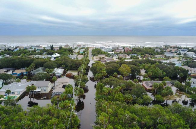
First is an image of South 23rd Street, which is normally my thoroughfare from my neighborhood, to A1A and the beach. As you can see, it is underwater. (With every shot, click on the image for largest view.)
In a second image, we see a white vehicle that attempted to drive out on South 23rd Street, but since the wake is in front of the car, well, it’s retreating back to the house:
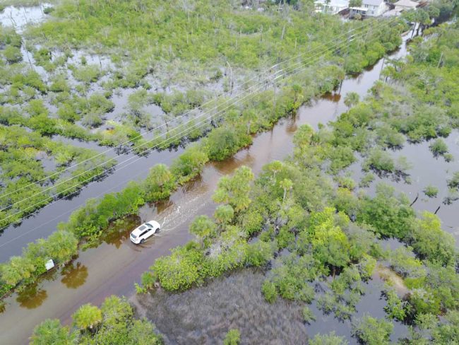
As for me, I ventured out in my car a couple of hours ago, and was proceeding cautiously until I spotted two young men in a kayak a couple of hundred yards in front of me, on the road. That was my signal to return home.
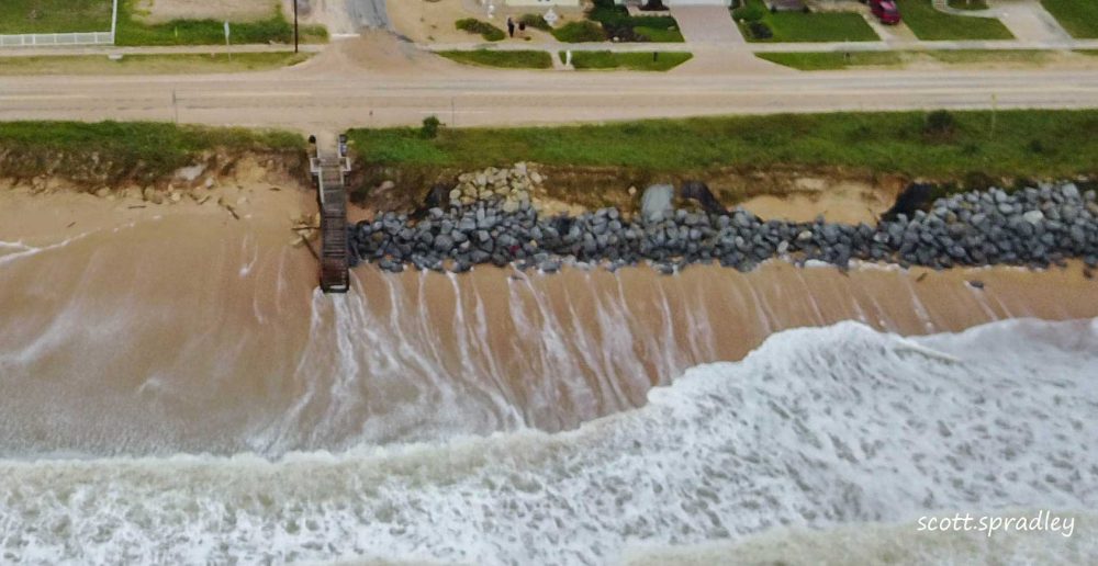
The next pair of images is of the beach erosion between South 23rd and South 24th Streets. The erosion is substantial. I hope to be on the beach for a detailed look within an hour or so, conditions permitting.
The next image, leading this post up top, presents a pretty shocking view of the neighborhood, with the Atlantic in the background. The flooding is substantial. Those are roads, not canals, that you see in this image.
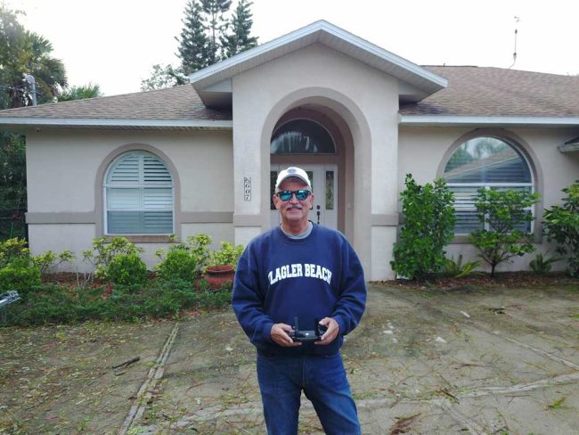
Finally, I have included an image of my street in which you see the flooded street. And the drone was kind enough to take a snapshot of me. As soon as the batteries recharge, I will send the drone out for more images and another report.
![]()
Before Ian, After Ian
Thursday, 9 p.m.–The theme of this post is “Before & After.” I will show and describe several pairs of images from my trusty Nikon, with one image in each pair displaying its subject before the arrival of Tropical Storm Ian, and one image displaying the same subject after Ian arrived.
It has been a long day here on the barrier island. I awoke at 3:30 a.m. primarily to check on the canal water level out back since it was high tide then. Seeing it was very high, I just stayed up waiting for daylight to go to the beach to see what Ian delivered overnight to Flagler Beach. What I observed was that the seas were churning mightily.
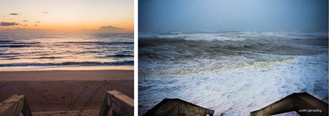
So the first before and after set of images, at the top of the post, was taken from the same spot on the South 23rd Street walkover, where I relax and take pictures in the mornings at sunrise. The first image was from a week ago, with a delightful dawn view of the beach, ocean and sky. The second image, taken today, also contains a view of the sky and of the ocean, but no beach. What a stark contrast. Hopefully the beach will return after Ian departs.
As the day rolled on, I ventured to my law office on South 5th Street, across from the Flagler Beach Pier. The second set of before and after images was taken from the same spot, at the South 5th Street walkover, where I have taken morning pictures for 10 years now, on those mornings that I go to work early and observe from there, rather than South 23rd Street near my home.
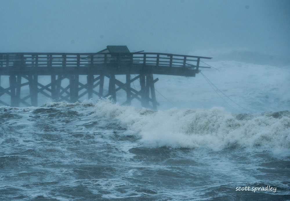
The first image was taken yesterday and shows the growling surf, with the Flagler Beach Pier standing at attention in the background. The second image was taken early this afternoon, and evidences the devastation to the Flagler Beach Pier caused by Ian. I still can’t get over the fury of the waves, which in the second image, tower over the already stricken pier. Such a sad sight for us all:
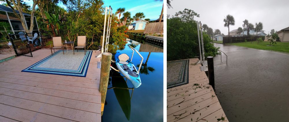
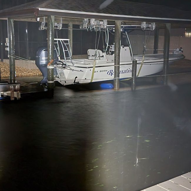
After leaving downtown Flagler Beach and returning home, I again returned to my dock to check on the water level in the canal. To my disappointment, the water levels increased and continue to rise as I write this post. The third set of before and after images was taken from the same spot on my dock.
The first was a few weeks ago when the canal was at a normal level. The second image was taken this afternoon, and the rise in water level is clearly displayed. It simply should not be that high:
And what happens if it continues to rise? Well, I’m going to just leave it there and hope that dawn tomorrow will see a return to normalcy following the departure, with finality, of Ian.
Still unknown at this point is the condition of the beach after today’s steady howling winds, whether the intracoastal waterway will flood any residences as it did during Irma, whether A1A is intact, and whether the Flagler Beach Pier sustained additional damage beyond that which was recorded today. All of this is enough for one day. I will again be observing and reporting early tomorrow, hopefully with answers to these unresolved issues. Until then…
Cheers and be safe,
Scott
![]()
Pier Heartbreak
Thursday, 3:00 p.m. — As heartbreaking as it is to many, the destruction to the end section of the Flagler Beach pier was inevitable on many levels. First, the pier is scheduled for demolition and replacement by a concrete version of itself, beginning next year. Second, it is simply the case that Mother Nature is undefeated.
And with a history of builds, rebuilds, and significant repairs, it was too much to ask that the pier withstand yet another sustained blow–this time from a large, at times violent storm which has been hammering away all day long. This isn’t the end, either. According to reports, we are in for another 6 or so hours of 40 mile an hour winds. Who knows what will be left of the pier at that point. I will keep you post. Until then, Scott
![]()
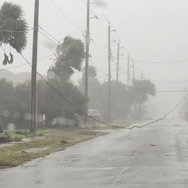
Waves Break Over A1A, Downed Power Lines
Thursday, 11:25 a.m.– The weather on the island is quickly deteriorating which has led to critically dangerous conditions on the island side of Flagler Beach.
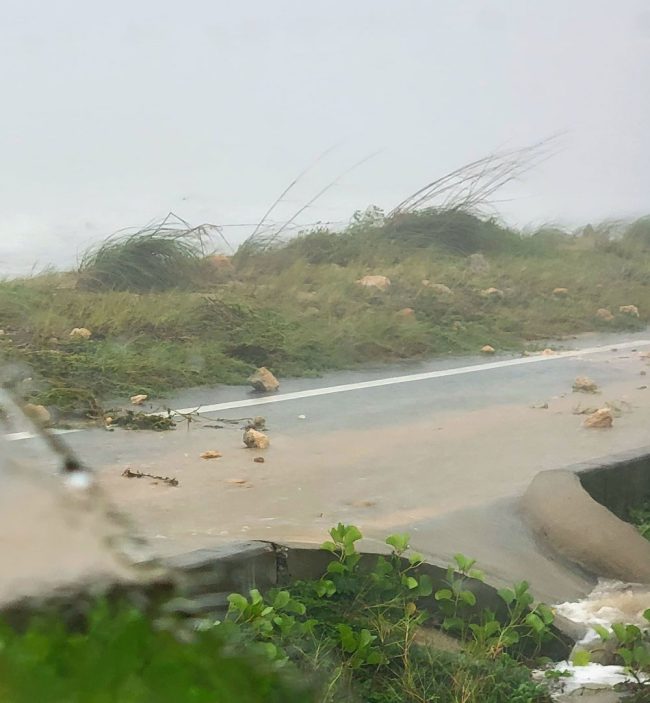
I attempted to return to my office a few minutes ago by way of A1A. I was stunned to sea waves breaking into the dunes and into the northbound lane of A1A. This was occurring on A1A from South 16th Street to, at least, South 14th Street. Consequently, the northbound lane of A1A is littered with rocks of varying sizes, including rather large ones. I did not venture past South 14th Street, but instead came straight home using Flagler Avenue.
With the high winds scheduled to continue until midnight, I expect this situation will get worse, with a possible reprieve coming when low tide occurs at approximately 4:30 p.m. That’s a long time from now. A1A will be tested between now and then. Moreover, the interior roads (Central, Daytona and Flagler) are all subject to down lines, whether power or cable. I reported those that I saw.
Finally, the water level behind my house (South 23rd Street area) continues to rise and has nearly breached the seawall. Likewise, the roads in the area are beginning to flood. I have heard from several neighbors who would be unable to leave their homes by car, even if there was a need to. With that said, my next trip to the office will be after the storm departs. I still have power at my house, but many neighbors are reporting that they do not. I may walk to the beach in a while, if conditions are safe and will report what I see. Until then…
Cheers and be Safe, Scott

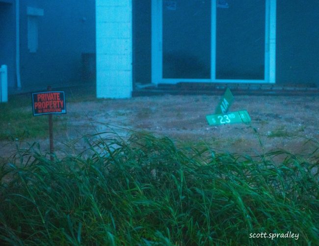
Ferocious Conditions in Flagler Beach
Thursday, 9:20 a.m. — One word: Ferocious. That describes the current conditions on the island side of Flagler Beach. And it is expected to stay that way until after midnight tonight.
The 1.5-mile journey from my house on the southside of town to my office on South 5th Street was fraught with car-rattling bursts of wind and with pelting rain that felt like small stones when I stepped outside. There was also a road-straddling power line that I reported to the City and FPL (South Central between 23rd and 24th). My advice: Stay inside. The good news is, most apparently are.
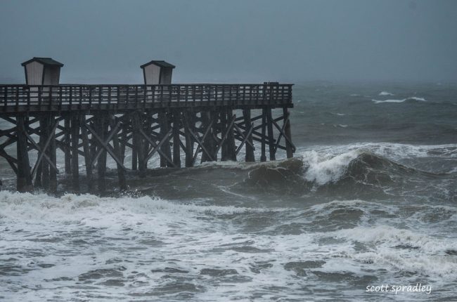
The only vehicles I saw on my journey to the office and back were Flagler Beach police cars and a couple of neighboring business owners, including my man Scott Fox at Tortugas, who were all checking on their facilities, as was I. As far as conditions: wow. The ocean is in full storm mode as evidenced by the image of the Flagler Beach Pier shown below. The roads are beginning to flood.
I also made a quick visit to the South 23rd Street walkover, where I take my daily photographs of sunrise (no sunrise visible today) and instead of a foreground of beach, there was only a lens full of ocean. Speaking of South 23rd Street, I noticed the street sign was missing, and after a hasty search, I found it in a neighboring yard. Apparently, the sign can’t read signs. More information, including up to date weather and canal water levels will be described in the next post. I need to dry off! Until then…
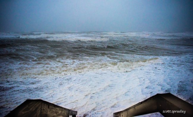
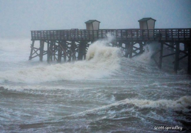

Ian’s Tropical-Force Wings Are Here. So Is Erosion.
Wednesday, 8:25 p.m.– It’s nearly dark on the first full day of the effect of Hurricane Ian. Notably, Ian is now a land based storm, as it continues its trek Northeast toward Flagler Beach. As of this writing, it remains unknown the exact time of the storm’s ultimate arrival, or its strength when it does arrive.
Having just left the Beach at South 23rd Street, however, I am here to tell you that the tropical winds driven by Ian are here. I clocked gusts of 42 miles per hour and the sustained winds were not much below that at sea level. Moreover, the ocean is in full storm mode, as it is impossible to discern a wave having a form lasting more than a second or two.
Back here at the house, the large pine trees in my neighborhood shield me from the brunt of the winds I experienced on the beach, even though I am but a few blocks from the sand. Currently, there is a sustained wind of 21 miles per hour, with gusts not much more than that. It is amazing what a few tall trees can do if in the right location.
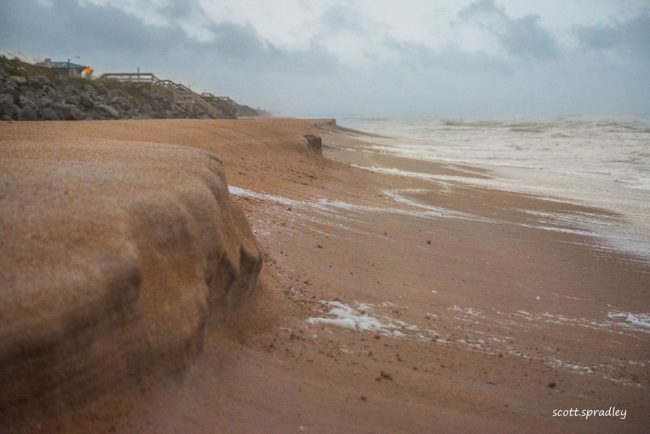
I am here to report a few developments: Storm erosion is pronounced on the beach, even though tropical winds arrived just a handful of hours ago. As you can see in the photo above, the ocean has carved the sand into a series of sharp angled protrusions, turning the beach into a split levelled affair–at least for the time being. I am anxious to see and then report the condition of the beach at dawn Thursday, which will mark a full 24 hours since the effects of Hurricane Ian first began here.
In addition to beach erosion, the water level in the canal behind my house, and in turn, the water level of the Intracoastal Waterway, is on the rise. I was admittedly let down when the level after high tide this afternoon continued to rise, instead of falling, as I had hoped. The scenario is eerily similar to the lead up to Hurricane Irma in 2017, which we all know was a disaster for many Flagler Beach homeowners and renters near the ICW at the time.
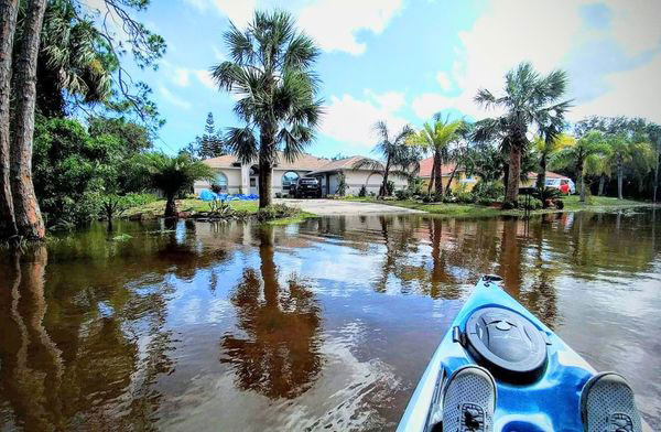
As for me, my house (which I bought just a few months earlier) was the only house on my street that did not flood, but it was close. I spent the day after Irma cruising the neighborhood in my kayak (see before and during photos below). Hopefully a repeat performance of that is not in store for me.
By dawn tomorrow, we should have an idea of what flood potential there will be at the hands of Hurricane Ian. Since high tide on the ICW in our area is at 4:01 a.m. tomorrow, I will rise early, and report soon after that. Until then…
![]()
First Churns
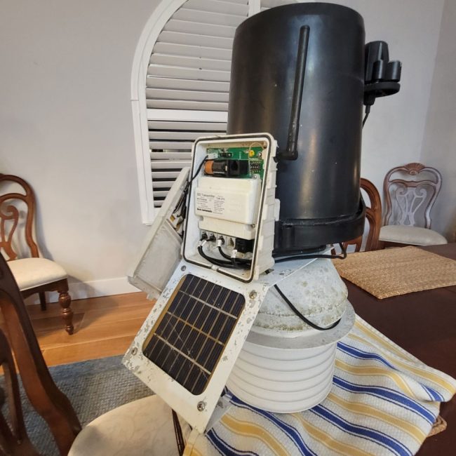
Wednesday, 3:35 p.m.– Even though Hurricane Ian is 2 full days away from Flagler Beach, its calling card has arrived. Since late morning, rain bands have become more and more prevalent. Wind speed is picking up steadily, and with it, gusts are on the rise. As I write this, current sustained winds are 22 miles per hour, with a gust or two registering at 33 miles per hour. My method of measuring weather conditions is a personal weather station at my home.
Wind instruments are on the roof, and instruments measuring rainfall, barometric pressure, humidity and solar radiation, are located on my dock. The raw data from both sets of instruments is transmitted wirelessly to a console in my home, connected to my PC. From there, the data is processed and uploaded to the National Weather Service, Wunderground.com, WeatherBug, and a few other places. Here is a link to the weather station, known as Station South Flagler Beach, KFLFLAGL24: https://www.
Since my last post, I made a visit to my law office on South 5th Street, following which I crossed A1A to check out surf conditions by the Flagler Beach Pier. The surf is noticeably rougher than it was this morning. A peek into a washing machine in suds cycle comes to mind. While looking over the agitated surf, I also took a few images of the beach itself so that I can do a before and after comparison following the arrival and departure of Hurricane Ian.

![]()
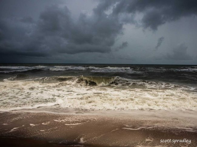
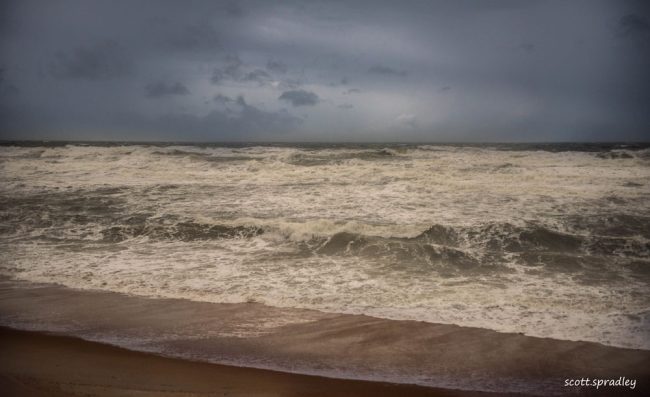
Wednesday, 11:50 a.m.–This morning started like all mornings at South Flagler Beach. I was on the Beach before dawn, enjoying the serenity of the moment and waiting for a photo op with Mother Nature. Due to the effects preceding the arrival of Hurricane Ian in a couple of days, the sun did not participate in the visible sunrise. But I did capture an image of the churning ocean as the first effects of Ian have arrived.
Over the next few days, I will document the arrival of Hurricane Ian with my narrative, with my photos, with weather data from the Personal Weather Station at my South Flagler Beach house, and with drone photographs and videos of the area following the departure of Hurricane Ian.
I will also document beach erosion at South 23rd Street, which is my destination each morning. I hope the drone photos will suggest minimal damage and disruption of the neighborhood and surrounding area. More to come.







Leave a Reply