Last Updated:5:22 p.m.
The center of Tropical Storm Nicole was about 300 miles southeast of Flagler Beach in mid-afternoon today, but the vastness of its strength and impacts was apparent up and down Flagler County’s coast, with most pronounced damages to dunes south of the Flagler Beach pier and toward the Flagler-Volusia County line.
State Road A1A itself remains largely unscathed, if barely so in some places: just past noon today an excavator and a bulldozers were hurriedly dumping loads of ebony-brown sand–clearly acquired in a hurry from the nearest-available supplies–into a semi-crater the waves had carved out around a walkover at South 21st Street. If the hope was to limit further damage, the longevity of that sand was uncertain.
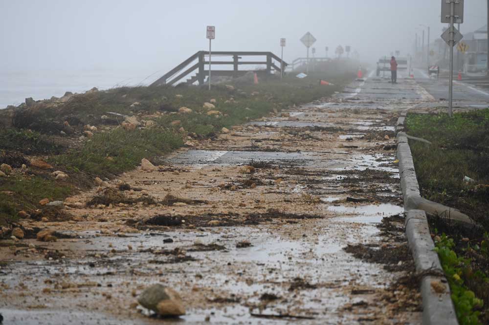
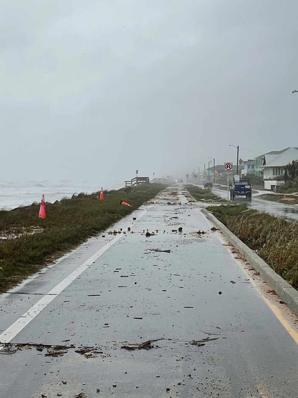
Much of the damage was inflicted at high tide this morning by crashing waves that rose over 10 feet and overtopped what remains of the dunes along A1A. Because of the amount of rocks and debris covering it, the road was closed to traffic from South 6th to South 16th Street this morning, and remained closed for the rest of the day. It’s unclear if the road itself was damaged. But its drainage systemn was overwhelmed at one point.
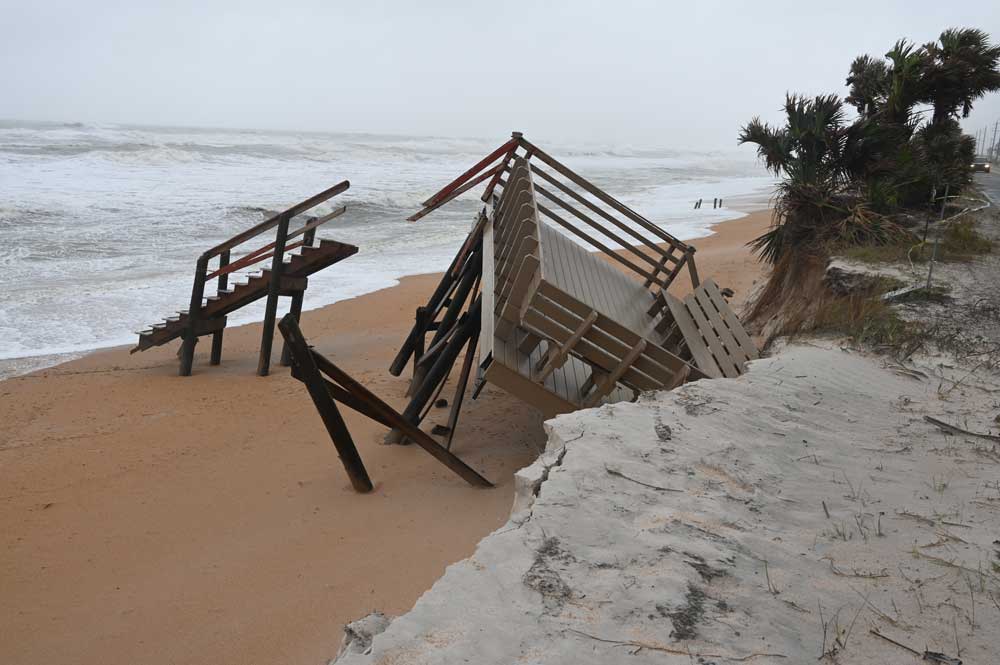
A privately-owned deck and walkover at the south end of Flagler Beach was in pieces (see the picture above). That stretch of dunes, from the Flagler Beach water tower south, past the county line and into Ormond By the Sea, had been the target of two weeks of dune-replenishment by the Florida Department of Transportation until the eve of the storm’s arrival. The sand had been trucked in at the rate of over 500 cubic yards a day, from Hawthorne, near Gainesville. About 40 to 50 percent of that sand is now gone, though what remained today was evidence that it had at least blunted more severe damage or encroachment against A1A.
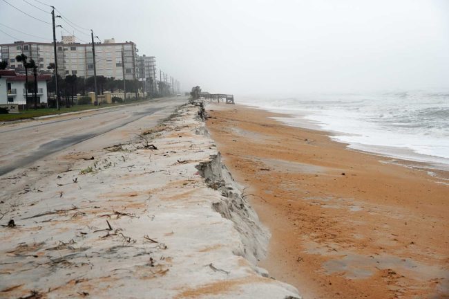
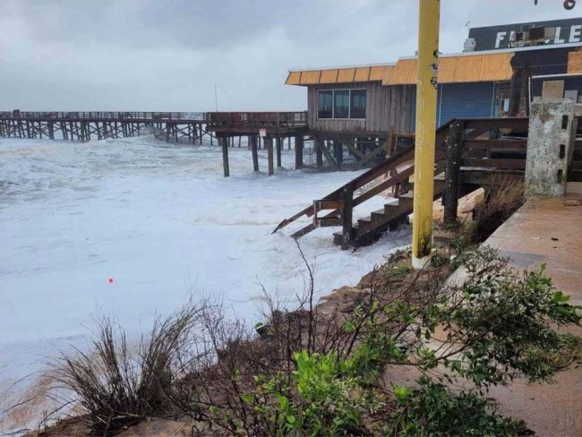
Conditions were worsening by the hour as Wednesday wore on, with the brunt of the storm’s effects expected overnight and into Thursday, according to Jonathan Lord, Flagler County’s Emergency Management director. Low tide was at 2:37 p.m., but even then, waves were crashing near the dunes. Another high tide was cresting at 8:30 p.m. Through it all, the Flagler Beach pier somehow managed not to lose more segments,m even though its easternmost end appears to be hanging by a thread.
Nicole was forecast to strengthen to a Category 1 Hurricane late this afternoon or this evening, according to the National Weather Service in Jacksonville, with a tropical storm warning in effect for the entire Flagler County coast. Tropical storm conditions were evident this afternoon along A1A, where sustained winds made it difficult to stand ort walk. And in fact the weather service confirmed what visitors to the shore experienced: “We have received multiple reports of wind gusts of 45-55 mph along NE FL and SE GA coasts and reports of surge inundation and overwash along the NE FL coast during high tide today,” a 4 p.m. Weather Service update stated.
Conditions were sharply calmer across the bridge, where rain or drizzle, not strong winds, were the issue for most of the day.
“Destructive beach erosion is likely, with breakers of 10-15 feet expected at the beaches through early Friday,” the Weather Service said in its afternoon briefing.
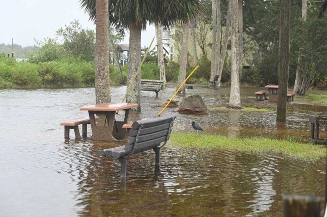
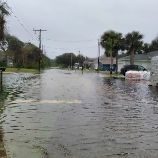
Tidal flooding was spotted in parts of South Flagler Avenue and at Custer Park–which was under water–along Palm Drive in Flagler Beach early this afternoon. But the water was nowhere near any homes.
Evacuation orders for the barrier island were issued today for 3:30 p.m. But if much of the island’s population intended to leave, that was not evident for much of the afternoon, as school buses dropped off children, some businesses (not many) still operated, and light traffic was in part made up of storm tourists, their smartphones brandished against the surf. There was heavier traffic westward than eastward into the island, but nothing indicating flight.
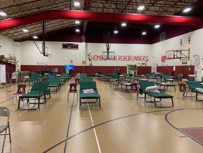
In Palm Coast, the one emergency shelter arranged in conjunction with the evacuation opened this afternoon at 3:30 p.m. at Rymfire Elementary. Its special needs section is run by staffers from the Flagler Health Department, in the main gymnasium. The shelter, in different parts, will also accommodate general population guests and pets, and will have security provided by the Sheriff’s Office. Bob Snyder, the director of the health department, was not expecting a significant operation.
The National Weather Service’s 4 p.m. update summed up what’s ahead this way:
-
Extremely Hazardous Coastal Conditions worsen today & continue through Friday – Prepare for devastating beach erosion, damaging surf and frequent rip currents.
-
Prepare for Storm Surge Inundation of 3-5 ft along the local Atlantic coast, Intracoastal Waterway and the St. Johns River basin.
-
Trapped tides in the St. Johns River will exacerbate and prolong tidal flooding into the weekend. That’s what explains the flooding in low-lying areas of Flagler Beach.
-
Prepare for Significant Wind Damage in Watch & Warning Areas. Impacts will include tree damage, power outages and damage to some structures, including roofs and mobile homes.
-
Local Tornado threat increases during the pre-dawn hours Thursday for Northeast Florida, including Flagler County, then shifts northward up the Southeast Georgia coast through midday Thursday, extending inland toward the Highway 301 corridor.
-
Localized flash flooding is possible for areas east of Highway 301 in Northeast Florida. Storm total rainfall 3-6″, locally higher possible mainly along the St. Johns River and the Flagler County coasts.
See today’s previous updates below the picture.
![]()
Tropical Storm Nicole Thrashing A1A, With Severe Coastal Damages Expected Today and Thursday
Wednesday, 8 a.m.–Don’t be fooled by the shift in Tropical Storm Nicole’s path. The storm remains potent, its reach broad and its expected impacts on Flagler County’s shoreline severe.
That’s the message from Flagler County Emergency Management Director Jonathan Lord and the National Weather Service in Jacksonville this morning–a message he wants both the public to hear, and the local officials he was speaking to collectively in a scheduled call early today.
While the path of Tropical Storm Nicole’s center has shifted slightly south and west, curving around Flagler, “the impacts for Flagler County have not changed enough where we can make any changes on our recommendations or the evacuation orders,” Lord said just before 8 this morning. “Our evacuation orders will still be kicking in at 3:30 this afternoon. We continue to expect coastal flooding, we continue expect Intracoastal flooding and we continue to expect a decent amount of rain of 3 to 6 inches countywide.”
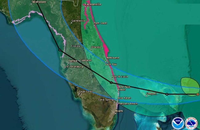
Little by little over the National Hurricane Center’s last reports Tropical Storm Nicole’s path has shifted south and east just enough to move all of Flagler County out of the cone of probability of a direct hit. But Nicole is still far enough offshore–240 miles east of West Palm Beach–that further shifts could again move that cone to Flagler’s disadvantage. But the cone itself is not the focus of emergency and weather officials, particularly with this kind of storm.
The drainage system along the south end of State Road A1A was overwhelmed this morning, as indicated in this video by Flagler Beach Mayor Suzie Johnston:
“I have a bunch of people say to me, yeah, so the cone has shifted,” Lord said. “”The loan is only the center of the storm. It depicts the where the center of the storm may be. And technically a third of the time that cone can be wrong. That’s why it shifts. It unfortunately does not reduce the expected impacts we’ve been talking about for the last week or so for us. While the hurricane watch has been dropped, they did that too when the cone shifted at 5 o’clock this morning, again, I had a really good chat with the weather service this morning already. It does not change the expected impacts.”
There were never expectations of devastating impacts inland, but the same amounts of rain are in the forecast, along with winds in the 20 to 30 mph range in all parts of the county, and no ruling out tropical storm force gusts.
The National Hurricane Center’s message is the same: “Do not focus on the exact track of Nicole since it is expected to be a large storm with hazards extending well to the north of the center, outside of the forecast cone. These hazards are likely to affect much of the Florida peninsula and portions of the southeast United States.”
Meanwhile, reports have been coming in of impacts on State Road A1A, where waves are overtopping what remains of the dune system–in places, there are no dunes left–and littering the road with rock debris. A1A northbound from South 16th Street in Flagler Beach has been closed to traffic. Just north of Marineland, a few yards past the Flagler-St. Johns County line, the ocean has topped over the road, creating the first reported breach through the dunes. The breach is at a location prone to breaches, and where reinforcement sand had been dumped ahead of the storm. The sand has washed away.
Mayor Johnston says she took this video, of waves drenching a passing Flagler Beach Police Department patrol car, half an hour before high tide:
“At this point the bridges are open and will remain open. The only reason they’d be closed is if winds are sustained at 45 mph because then it’s too dangerous to go over the bridge,” Sheriff Rick Staly said in late morning Wednesday. “As far as a curfew, I’m sure at the 2 p.m. policy discussion today we will talk about that, but at this point there are no curfews planned. My concern obviously is if people evacuate, I don’t want the criminal element to think they can prey on homes or businesses on the barrier island. So regardless of whether a curfew is in effect or not, we will have extra patrols.”
With schools out and courts closed, that frees numerous deputies to be reassigned to different patrols, the sheriff said. But he urged residents not to go over the bridge to the barrier island just to gawk and get in the way of those trying to evacuate–or risk getting hurt by storm impacts. He said people can catch a glimpse of the ocean through videos already available.
Here’s a live shot panning the area areound the Flagler Beach pier:
Flagler County schools are operating this morning. But they are closing early, with middle schools dismissing at noon, high schools dismissing at 1 p.m., and elementary schools dismissing at 2 p.m. Schools are closed Thursday. They were scheduled to be closed Friday in observance of Veterans Day. Courts and some government offices are closed for the rest of the week, and garbage collection in Palm Coast has been suspended for Thursday.
At 7 this morning, Tropical Storm Nicole had sustained winds of 70 mph, 4 mph short of hurricane strength. It was moving at 13 mph toward the Florida coast. It is expected to make landfall late tonight or early Thursday morning between Port St. Lucie and West Palm Beach as a Category 1 hurricane.
A dangerous storm surge is expected along much of the east coast of Florida and portions of coastal Georgia, the NHC warns. The storm surge will be accompanied by large and damaging waves. Residents in the warning area should listen to advice given by local officials. The National Weather Service in Jacksonville specifies: “Well ahead of the system we will have strong onshore winds, moderate to possibly major coastal flooding, locally heavy rainfall, major beach erosion and possibly damaging surf.” Minor flooding in parts of the St. Johns River is ongoing, and will continue to worsen through the week to moderate or higher-level flooding.
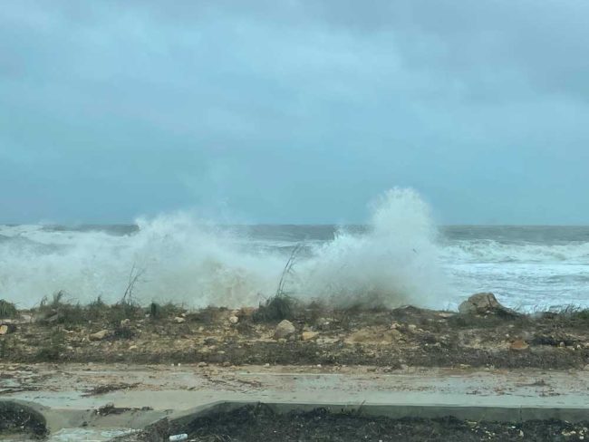
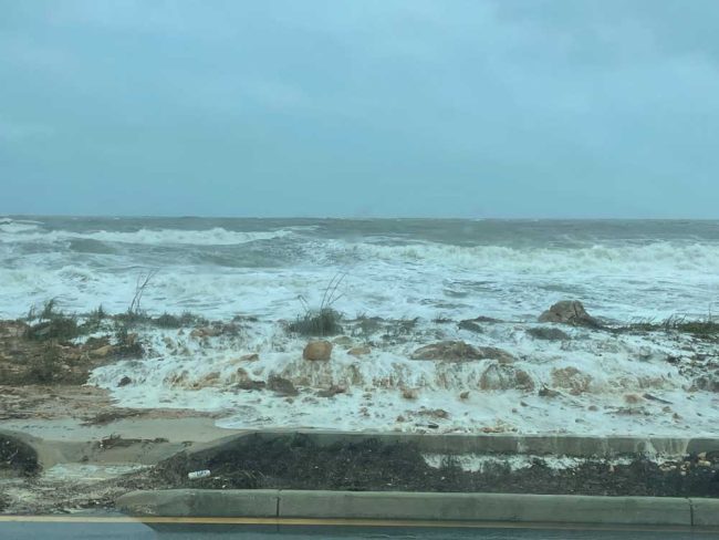
Locally, the effects of the storm will worsen as Wednesday progresses into Thursday, particularly on the coast, with elevated winds lasting into Thursday. “This is kind of a hybrid. It’s a tropical storm, but it’s also behaving almost like a front,” Lord said. “So we have these two factors happening that are causing these impacts. A lot of times if a hurricane or a tropical storm was on a similar path right now, a traditional tropical storm, for lack of a better term, we wouldn’t be seeing the kind of coastal impacts we’re seeing right now, because we’re quite far away from that center core of the storm. But again, because of the width of the storm, those impacts are so big, and because of the fact that it’s interacting with other systems coming down from the north, we’re getting this north easterly flow on shore pushing the water towards us.”
The latest briefing from the National Weather Service is below.
![]()


Leave a Reply