Last Updated: 1:07 p.m.
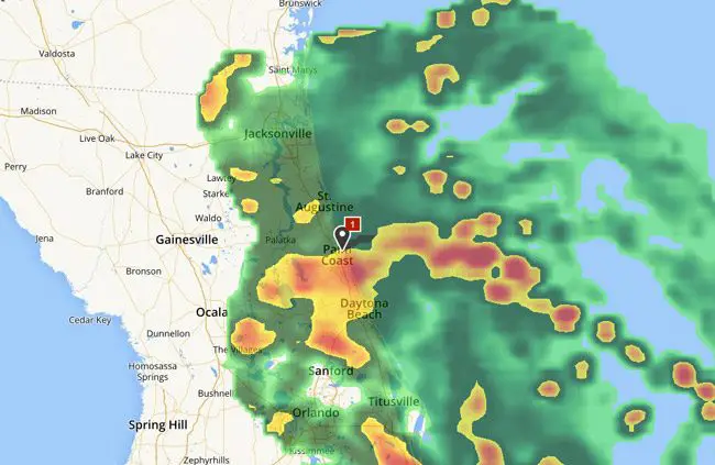
What a difference a name makes: There are no sandbag stations, no warnings about storm preparedness, school closings or potential shelter locations, but the unnamed tropical “wave” churning off the coast of Central Florida is expected to bring more rain and heavy thunderstorms over Flagler County in the next 24 hours than did Hurricane Hermine. Hermine in the end never affected this part of the state as it did the Big Bend area, where it made landfall.
The National Weather Service’s Ben Nelson this morning summarized what’s ahead for Flagler, St. Johns and Duval counties: “Low pressure currently moving onshore along the east central Florida coast will spread bands of heavy rainfall and embedded thunderstorms into the coastal counties of northeast Florida later this morning, with activity overspreading the rest of northeast Florida and southeast Georgia during the afternoon and evening hours.
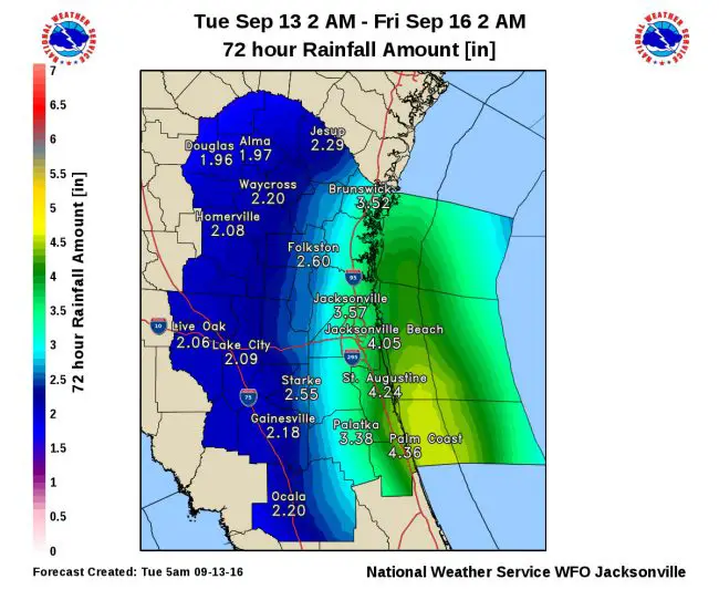
“This system will provide a more significant impact to coastal locations than Hermine, with intense rainfall rates possible this afternoon and tonight that will increase urban and low-lying flood concerns. Downpours will continue to stream over our region through at least Wednesday, with widespread rainfall amounts of 2 to 4 inches forecast. Coastal locations may receive upwards of 4 to 6 inches of rainfall during this event. Strengthening onshore winds today will create a high risk of rip currents at area beaches, and small craft advisories are in effect for the coastal waters through Wednesday morning.”
The Storm Prediction Center has placed the area within a marginal risk for severe thunderstorm development through this evening.
The Flagler Beach Pier has closed for the rest of the day because of high winds.
Coastal areas may experience a localized flood threat this evening through Wednesday, particularly during high tide when runoff is often blocked. High tide occurs along the Atlantic coast during the early evening hours tonight and again around sunrise on Wednesday. Wind gusts of 40-60 mph will be possible within heavier rain bands, as are waterspouts near shore. An isolated tornado is also possible at inland locations this afternoon.
Just after noon today, Bob Pickering, Flagler County Emergency’s weather specialist, posted the following wind reports from around the county:
Reading / Time / Location / Source / Notes
MG 36 mph / 0941hrs / Marineland / EM Wx Station Spotter in area reported Palm Frans coming off trees.
MG 39 mph / 1141hrs / Flagler Beach / Sustained wind 27 mph. Many gusts over 35 mph.
MG 41 mph / 1149hrs / Flagler Beach / Measured gust 41 mph.
MG 37 mph / 1218hrs / Marineland / EM Wx Station
(A former version of this story had referred to the weather system as a tropical depression. But as Pickering noted, “the system affecting Florida is not a Tropical Depression as defined by the National Hurricane Center. The system is officially classified as a Tropical Wave. Tropical waves many times include a weak area of low pressure but the winds are not strong enough to meet the Tropical Depression criteria.” If the system becomes more organized and turns into a depression, it would then be assigned a number.)
Caution: do not drive through waters of unknown depth. Persons who live in normally flood-prone areas should be prepared to take protective actions or move to higher ground in case of localized flooding.
The high temperature today is not exepcted to go much past 80, with overnight lows in the mid-70s. You can keep up with the Jacksonville weather station’s radar and webpage here.


Leave a Reply