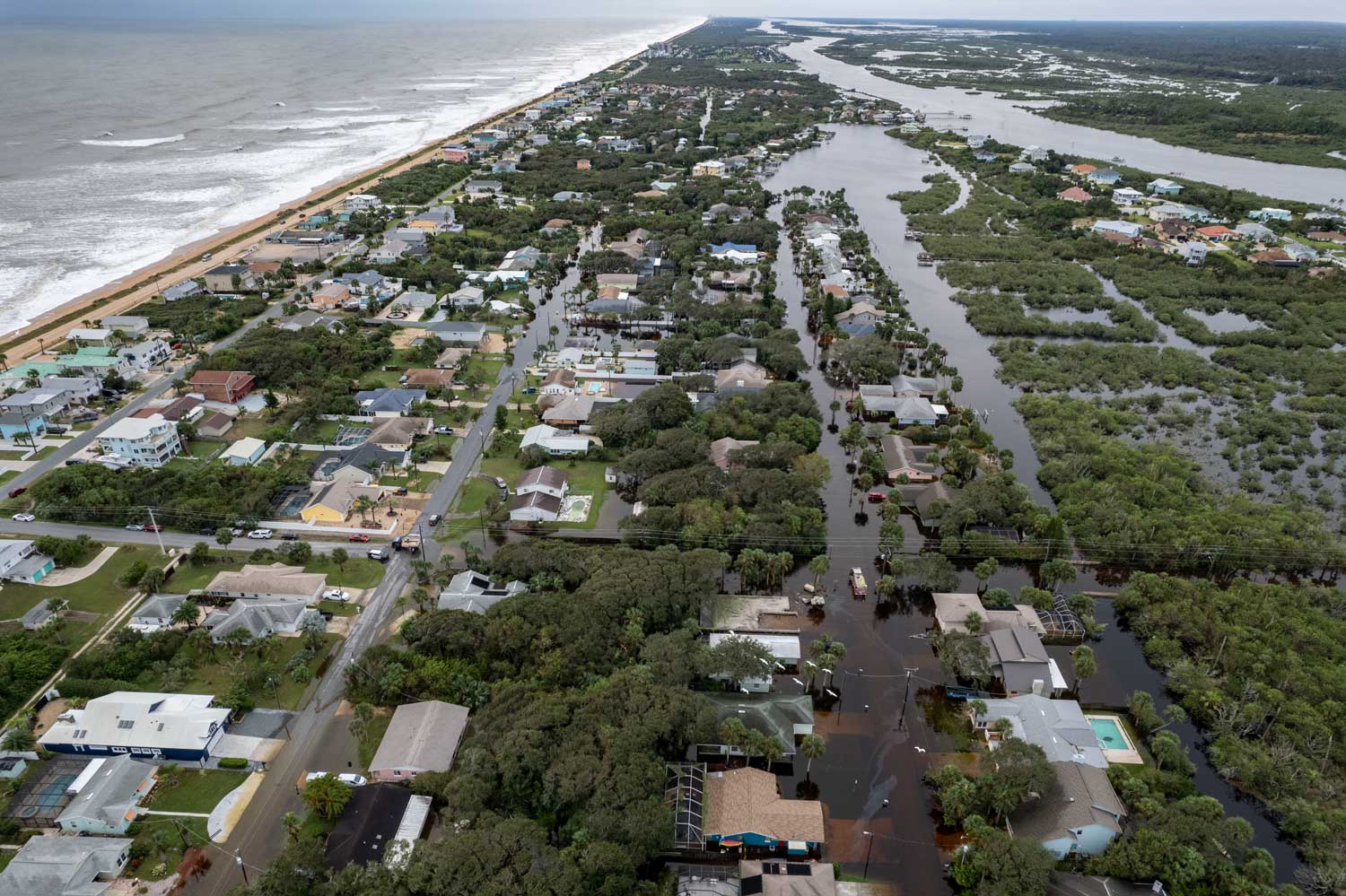
A final tally of Hurricane Ian’s impacts on Flagler County reveals limited property damage impact either from wind or floodwaters despite rainfalls totaling 15 inches in places. Flagler County is qualifying for three levels of aid from the Federal Emergency Management Administration, including aid to individuals.
“They’re not exact figures but we came up with 132 homes that were affected, which is 20 percent damage in some fashion,” Flagler County Emergency Management Director Jonathan Lord said Monday morning, “65 which were minor, and seven homes that were major. We did not have any fully destroyed homes.” Of these homes, 32 experienced some kind of water intrusion. Those numbers include Flagler Beach, where in the aftermath of hurricane Irma, some 400 homes had been flooded.
Four hours after the morning interview,. Lord, speaking before the County Commission, raised the amount of homes with some impact to 200, but did not change the number of homes with severe impacts.)(See full rainfall amounts broken down by region at the foot of the article.)
The damage to residential homes and other structures is estimated at $2 million. Local government spending related to Ian amounts to “easily well over $1 million dollars,” according to Lord. That will be reimbursable by the federal government, but it could take a year. Local reserves accounted for the dollars.
By Monday morning, power had been restored to all but 200 of Flagler’s 70,000 customers, after almost two-third had lost power at the height of the storm.
“We were extremely lucky,” Lord said. “This is not to say that if you were one of the homes that were impacted by the flooding that that’s not devastating for you, because it 100 percent is for those individuals. But as a community we are extremely lucky. Ian made landfall as one mile an hour before Category 5 on the West Coast. We’re not a very wide peninsula, but it traveled northeast towards us and it lost a lot of its strength. At the end of the day, we really only saw a tropical storm along the coast. Inland portion of the county, we did not see tropical storm force winds. However, we definitely saw tropical storm quantities of rain and it looks like depending on where you were in the county, we had anywhere from a low of six to a high of 15 inches of rain that was received. There could be areas that were higher. We just didn’t have people monitoring the rain in those spots, and potentially areas that were lower. So it’s it’s quite a swath of rain.”
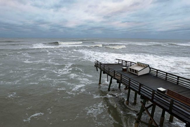
There were no road collapses along State Road A1A, though there was some road damage. Flooding there was limited to the west side of the barrier island. But the Flagler Beach pier suffered severe damage, with its front section lopped off. It is closed indefinitely.
Of significantly greater concern to officials and residents along the shore: while the dunes that were there did the job during Ian, the storm has largely taken them out. Ian has entirely removed what was left of the $18 million, 1 million tons of sand the county dropped along the shore in 2018 and 2019, in an effort to rebuild dunes lost during Hurricanes Matthew and Ian. It has carved out what remained of the dune structure in Flagler Beach just north of the pier. It has reduced the dry-sand beach at high tide. (See: “Catastrophic Loss: Dunes All But Gone Along Flagler’s 18-Mile Shore, Leaving A1A and Properties Dangerously Exposed.”)
It has moved the remaining dune-line–where there are dunes remaining–further inland. It has sheared off vast sections of sand from beaches at the north end of the county, exposing underlying rocks. The sewage system in marineland was damaged. There is still some flooding on the west side of Beverly Beach. High Tides at Snack Jack, the restaurant, suffered considerable damage both to its own structure and to surrounding dunes that have been carved out. The Funky pelican on the Flagler Beach pier has also had sand carved out from beneath its structure all the way back to the pier’s connection to the mainland.
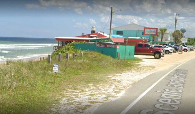
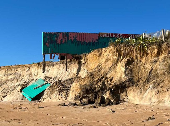
Lord surveyed the county and the beaches both by air and on foot over the last few days. “We saw a few breaches of the dune system, quite a few topping overs of the dune system,” Lord said. Topping over is when the surge’s waves crash over the top of the dunes. There was a lot of that throughout the county’s 18 miles of shoreline.
“In some areas, the sand on either side of where the dude was is pretty level, that’s where the dune system has gone,” Lord said. “In other areas, you see walls or cliffs. That means there’s still a dune system remaining. That’s why you have those walls and cliffs.” In sum, the dune system “did its job 100 percent,” Lord said. “It protected the infrastructure behind it. The issue is, the way it protected the infrastructure is by sacrificing itself. And our dune system significantly sacrificed itself for this storm.
The implications of the diminished or vanished dunes are many. The county must act fast to determine how it will rebuild protections. The sea wall from north Flagler Beach to Beverly Beach, completed in 2019, is ugly, its sand dunes vanished and its pilings now fully exposed. But state and local officials take note that, more importantly, the sea wall held: there was no damage to A1A behind it, to homes and businesses across A1A, in what had been an area of recurring damage previously. Flagler Beach officials and residents were reluctant to accept that sea wall, and were opposed to sea walls further south.
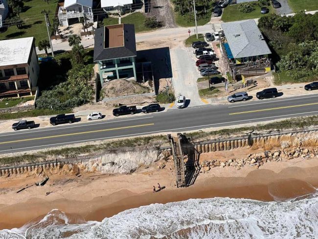
But the contrast between the sea wall and the diminished rock revetment at the south end of the city–the rock revetment protecting A1A–is stark, which may lead state transportation officials again to consider additional sea walls.
On the other hand, the U.S. Army Corps of Engineers, which is set to begin a 2.6-mile beach renourishment (or dune-rebuilding) project in Flagler Beach south of the pier, would not carry out that project anywhere there are sea walls. It sees it as needlessly duplicating costs. That project would go forward only assuming that one remaining property owner who’s been holding out against signing an easement does in fact sign.
For residents of the barrier island, there is another big implication from the diminished or disappeared dunes: next time there’s a storm, the orders to evacuate will be quicker and more urgent, because there is far less protection now.
“I know many, many people didn’t listen to us, this storm could have been a lot worse and it was forecast to be a lot worse. And we were very, very lucky,” Lord said. “Now that risk is even higher. So when people make that decision to stay behind and go oh, I was fine the last time, that risk is that much significantly higher, and there’s less of a protection system for people to ignore the evacuation order.”
Lord was more stark when a county commissioner asked him this morning how evacuation orders went. “Most people ignored it, unfortunately,” Lord said. Only a couple of hundred people turned up at the shelters. He had no doubt that many people found their own shelters among families and friends. But “based on what we saw the day after the storm where people were on the island or in those that got flooded, I think our residents ignored it. That concerns me immensely. We can only say it so much. That is their choice. We’re in a free country. That is their choice to do so. But I’d have to be honest, I don’t want to scare people, but I need to be a realist. What we saw in southwest Florida, can 100 percent happen here. We are not immune to that. And a perfect example is actually Michael from a couple years ago. There had never been a Category 5 in the panhandle. So they were very comfortable saying that we don’t get Category fives. Their building codes are actually weaker up there because they don’t get Category fives. You don’t get them until you do get them, so that is something I need to find a better way to double down on, that people truly, truly realize that.”
As for FEMA aid, the county has qualified for three levels of it.
The first level is for people who have no homeowner insurance or who are underinsured, and whose properties have suffered damage. Residents can apply for disaster assistance at disasterassistance.gov, by calling 800-621-3362 from 7 a.m. to 11 p.m., or by using the FEMA mobile app. If you use a relay service such as video relay service (VRS), captioned telephone service or others, give FEMA the number for that service. Aid is provided on a sliding scale of needs. In other words, don’t expect to be fully reimbursed, necessarily. Aid caps apply.
Flagler County also qualified for FEMA public assistance. Category B FEMA assistance is available for local governments to replenish their reserves after spending on first responder and other costs related to the emergency. Category A assistance is also available. That’s for debris removal. There’s not been much of it. But FEMA will reimburse governments for that. Those expenses are only starting to pile up today: it’s the first day that debris pick-up is taking place in the county and in Palm Coast.
“We are still pushing very very hard to get C through G Category FEMA,” Lord said. No area in Florida has yet qualified. That’s aid for infrastructure. “At this time it has not been approved for anybody in Florida.”
The emergency is not quite over. This morning the Department of Transportation closed portions of State Road 46 in Brevard County because St. Johns River waters are rising and flooding the road. Why is that of great concern to Flagler? Because St. Johns County flows north, and has been affecting the west side of the county. Lord said that flow is on its way, and may cause further flooding locally.
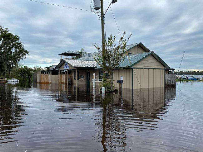
“Having seen the conditions of Bull Creek first hand,” County Commissioner Andy Dance said this morning in reference to an addendum to the lease for the county-owned property there, occupied by a restaurant, “it’s horrific to see that the waters are still increasing out there, the levels are not going down yet, that means that building has been inundated for probably over a week, two weeks maybe, and the damage assessment has been crucial, so I know we’ll get more updates on Bull Creek.” (Rent will be abated there until “there’s complete recovery from the storm,” County Attorney Al Hadeed said.)
This morning at the County Commission, County Engineer Faith al-Khatib explained to commissioner that with erosion on the beaches ongoing, the county was requesting an increase in sand for the U.S. Army Corps renourishment project in Flagler Beach, from 700,000 cubic yards to 1.33 million cubic yards. “Erosion is ongoing, we assume we need much more quantities of sand, and of course with the last event, we might come back with different quantities,” on top of the 1.3 million now requested, she said.
![]()
Rainfall amounts and peak wind gusts compiled from volunteer Skywarn spotters by Bob Pickering, Emergency Management’s weather specialist:
| Amount | Location | Source | Notes | Peak Gust | Location | Source | Notes |
| 9.35″ | Bunnell | EOC | CoCoRahs | 58 mph | Bunnell | EOC | |
| 6.00″ | Palm Coast | Skywarn | Library | 68 mph | Flagler beach | Skywarn | |
| 9.40″ | Palm Coast | Public | P section of Palm Coast | 56 mph | Palm Coast | WXSTEM | Bridge |
| 7.36″ | Flagler Beach | Skywarn | Central Flagler Beach | 39 mph | Rima Ridge | WXSTEM | |
| 8.33″ | NW Palm Coast | Skywarn | Belvedere Lane | 83 mph | Marineland | WXSTEM | Exposed |
| 10.47″ | West Central Palm Coast | Skywarn | R Section – CoCoRahs | 53 mph | NE Palm Coast | Skywarn | |
| 10.50″ | FC Airport | FC Airport | AWOS Station on the airfield | 42 mph | Palm Coast | Skywarn | |
| 9.20″ | East Palm Coast | Skywarn | East Palm Coast CoCoRahs | ||||
| 7.89″ | NE Palm Coast | Skywarn | NE Palm Coast CoCoRahs | ||||
| 8.5″ | West Central Palm Coast | Skywarn | Pine Lakes section of Palm Coast | ||||
| 10.45″ | Bunnell | Skywarn | Grand Reserve N of Bunnell | ||||
| 15.00″ | Bunnell | Bunnell | City of Bunnell Waste Water Plant | ||||
| 9.50″ | West Central Palm Coast | Skywarn | US 1 at Whiteview | ||||
| 14.00″ | North Bunnell | FFS | Forestry District 10 HQ US 1 | ||||
| 10.23″ | West Palm Coast | Skywarn | Rainmill Dr | Surge | |||
| 13.85″ | West Central Palm Coast | Skywarn | Lehigh Woods of Palm Coast | Height | Location | Source | Notes |
| 8.00″ | Northeast Palm Coast | Skywarn | Old Kings Road North in Palm Coast | 5.33′ | NE Palm Coast | Skywarn | Above MSL |
| 7.89″ | Northeast Palm Coast | Skywarn | Sailboat Country Canals near ICW | 4.00′ | Bings | NWS | Above MHHW |
| 7.45″ | Bulow | Skywarn | Bulow Proper |


Laurel says
I’ve lived in Florida all my life, and been through many hurricanes, and I’ve never seen flooding like this before. I’ve seen a few roads here and there, after a hard rain, but never like this. Y’all better think hard and long who you are going to vote for in November, and if it’s for climate deniers, think harder and longer.
There have been comments on this site such as “When is Palm Coast going to dredge the swales?” How deep? The water table is high. Other comments: “Palm Coast should do a better job pumping out the canals.” To Where? The ICW to overflow on other people’s properties?
As it is right now, Palm Coast has no real gravity system for sewage. It uses grinder systems that when the power is out, and there’s a lot of rain that goes into these systems, the sewage overflows onto the yards. More rain comes, and sewage is washed into the streets, canals and ICW. Terrible, terrible idea. The County will want to do the same to the Hammock, whereas the sewage will flow directly to the ICW, the very planning that’s supposed to rid the area of septic tanks to prevent waste water from entering the ICW.
I don’t know how the beach here can be “re-nourished” as the waves are different here than south Florida. Here the waves scallop out the sand regularly, and there are many more rip currents here than there. We’ll see, at great expense.
Face it folks, Florida does not have the capacity to house the world. I’ve watched, for many years, the quality of life, land and wildlife go continuously down, and developers will continues to take the money and ran leaving us holding the flooded bag. It’s not going to get better unless we control growth and take climate change far more seriously.
Capt Nemo says
Well, perhaps Flagler Beach can start by building a ” HURRICANE WALL ” . Build it 100 feet high and 1 city block thick. Build it starting up around the Palm Coast Toll Bridge and ending down near High Bridge road. Start the base around A1A and Rt 100 intersection. Why bother worrying about seeing the ocean. Just keep those morons who built or bought houses on the barrier island protected.
Another Cat 5 or Cat 6 could be just around the corner. Back in the Jurassic period on earth, there where Hurricanes with over 500 mph winds. Its not climate change….It’s the POLES SHIFTING !!!!!
Laurel says
Capt. Nemo: “Just keep those morons who built or bought houses on the barrier island protected.” Well, brain trust, check out the flooding inland. Start with Orlando.
Consider another state.
Local angler says
This is probably an unpopular opinion. But maybe there needs to be a discussion about not allowing new construction on the island.. or rebuilding severely damaged homes. Flooding is getting out of control and that land originally acted as a buffer zone for impacts and flooding. We turned it into pavement.. it needs to be restored to the marsh land it was and in some ways still is if anyone wants to live in the area inland in the future.
Aj says
A little humor. The fire danger is low to nonexistents.
sssFace says
This is such an important update for our community. It’s heartbreaking to see so many homes affected, but I’m glad to hear FEMA aid is on the way. I hope the efforts to manage floodwaters improve soon; we can’t endure another disaster like this. Thank you for keeping us informed!