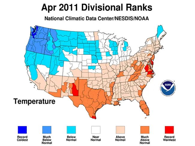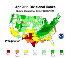
Historic flooding, a record-breaking tornado outbreak and devastating wildfire activity made April 2011 a month of historic climate extremes across much of the United States, according to scientists at NOAA’s National Climatic Data Center (NCDC) in Asheville, N.C.
Click On:
- Flagler Reinstates Burn Ban Indefinitely as Rain Proves Too Scarce to Dampen Kindling
- Downed Trees and Powerlines in Wake of Violent Storm That Shook Flagler
- Military Training Likely Source of Morning Rattling or Minor Temblor in Flagler
The average U.S. temperature in April was 52.9 degrees F, which is 0.9 degrees F above the long-term (1901-2000) average. April precipitation was 0.7 inches above the long-term average, the 10th wettest April on record. This monthly analysis, based on records dating back to 1895, is part of the suite of climate services NOAA provides.
U.S. Climate Highlights – April
Fueled by record-setting precipitation totals, historic and near-historic flooding occurred throughout the Midwest and Ohio Valley, from the smallest streams to the largest rivers. The Ohio Valley region had its wettest April on record and it was the second wettest for the Northeast. Illinois, Indiana, Kentucky, Ohio, West Virginia and Pennsylvania each had their wettest April since 1895. An average of 11.88 inches of precipitation fell across Kentucky, nearly three times its long-term average, breaking the previous record (7.61 inches in 1972) by more than four inches.
Nationally, the overall drought footprint across the contiguous U.S. remained above average, but decreased slightly from the beginning of the month to approximately 22 percent. The area of the country affected by the two most intense drought categories (D3, Extreme and D4, Exceptional) has increased for 10 consecutive weeks. Much of this very intense drought is focused in the Southern Plains and Southern Rockies.
In Texas, drought intensified making it the fifth driest April on record. The U.S. Drought Monitor classified 94 percent of the state as “Severe” (the D2 category) to “Exceptional” (D4, the most intense designation) drought.
Prime wildfire conditions prevailed across portions of the Southern Plains and a record breaking 1.79 million acres burned across the country in April. Texas, where over 2.2 million acres have burned since January, again bore the brunt of the wildfire activity.
Several violent tornado outbreaks impacted the country during April. According to data from NOAA’s Storm Prediction Center, the number of confirmed tornadoes for the month may approach the previous all time monthly record of 542 tornadoes which struck the U.S. in May 2003.
Much of the southern and eastern U.S. experienced above-normal warmth in April. Based on preliminary data, Delaware had its warmest such month on record. It was the fourth warmest April for Virginia and the fifth warmest for Texas. Other states with much above normal warmth include: Florida and Louisiana (seventh warmest), New Mexico and West Virginia (eighth), New Jersey (ninth) and Maryland (10th).
The Northwest was much cooler than normal during April. Washington State (second coolest, five degrees F below their long-term average), Oregon (fifth coolest) and Idaho (10th coolest) were all much cooler than normal.
U.S. Climate Highlights
February – April
The Northeast and Ohio Valley regions had its wettest February-April period on record. Indiana, Kentucky, Ohio, New York, and Pennsylvania set precipitation records. Other states with much-above-average precipitation for the period were: West Virginia (second wettest), Illinois and Vermont (third), Michigan (fifth), Missouri (sixth), and Washington (ninth).
Exceptionally dry conditions have parched the soil and vegetation in Texas, which has recorded precipitation of just 1.68 inches on average across the state since Feb. 1. This is the driest February-April period on record for Texas, nearly an inch less than the previous record (2.56 inches, February-April 1996). Also much drier than normal were New Mexico (seventh driest) and Louisiana (eighth driest).
Temperatures during the February-April period, when averaged across the nation, were near the 20th century average. However, the Northwest was cooler than normal, while the South and East coasts were above- to much-above normal.
According to NOAA’s Climate Prediction Center, La Niña conditions continued through April 2011 and are expected to transition to neutral conditions by early summer. The February-April U.S. temperature and precipitation patterns were largely consistent with those commonly associated with an early spring La Niña episode.

The rolling 12-month (May 2010-April 2011) period shows record wetness for Minnesota, North Dakota and Wisconsin which has contributed to flooding along rivers and streams in that region. The Great Lakes region had its wettest such period and it was much above normal in the Northeast, Central, Upper Great Plains, Northern Rockies and Northwest.
Above average warmth has occupied much of the nation during the 12-month period. Only the Northwest has experienced average temperatures that were below the 20th century average.
Year-to-Date Period
The year-to-date January-April period average precipitation has been above- to much-above normal across the northern tier of the country. Record precipitation averages in New York and Pennsylvania contrasted with the third driest such periods in Texas and New Mexico.
NCDC’s State of the Climate analyses, which assess the current state of the climate, are released soon after the end of each month. They are based on preliminary data, which are subject to revision. Additional quality control is applied to the data when late reports are received several weeks after the end of the month and as new scientific methods improve NCDC’s processing algorithms.


Leave a Reply