• Skip to primary navigation
  • Skip to main content
  • Skip to primary sidebar
MENUMENU
MENUMENU
  • Home
  • About
    • Contact Us
    • FlaglerLive Board of Directors
    • Comment Policy
    • Mission Statement
    • Our Values
    • Privacy Policy
  • Live Calendar
  • Submit Obituary
  • Submit an Event
  • Support FlaglerLive
  • Advertise on FlaglerLive (386) 503-3808
  • Search Results

FlaglerLive

No Bull, no Fluff, No Smudges

MENUMENU
  • Flagler
    • Flagler County Commission
    • Beverly Beach
    • Economic Development Council
    • Flagler History
    • Mondex/Daytona North
    • The Hammock
    • Tourist Development Council
  • Palm Coast
    • Palm Coast City Council
    • Palm Coast Crime
  • Bunnell
    • Bunnell City Commission
    • Bunnell Crime
  • Flagler Beach
    • Flagler Beach City Commission
    • Flagler Beach Crime
  • Cops/Courts
    • Circuit & County Court
    • Florida Supreme Court
    • Federal Courts
    • Flagler 911
    • Fire House
    • Flagler County Sheriff
    • Flagler Jail Bookings
    • Traffic Accidents
  • Rights & Liberties
    • Fourth Amendment
    • First Amendment
    • Privacy
    • Second Amendment
    • Seventh Amendment
    • Sixth Amendment
    • Sunshine Law
    • Third Amendment
    • Religion & Beliefs
    • Human Rights
    • Immigration
    • Labor Rights
    • 14th Amendment
    • Civil Rights
  • Schools
    • Adult Education
    • Belle Terre Elementary
    • Buddy Taylor Middle
    • Bunnell Elementary
    • Charter Schools
    • Daytona State College
    • Flagler County School Board
    • Flagler Palm Coast High School
    • Higher Education
    • Imagine School
    • Indian Trails Middle
    • Matanzas High School
    • Old Kings Elementary
    • Rymfire Elementary
    • Stetson University
    • Wadsworth Elementary
    • University of Florida/Florida State
  • Economy
    • Jobs & Unemployment
    • Business & Economy
    • Development & Sprawl
    • Leisure & Tourism
    • Local Business
    • Local Media
    • Real Estate & Development
    • Taxes
  • Commentary
    • The Conversation
    • Pierre Tristam
    • Diane Roberts
    • Guest Columns
    • Byblos
    • Editor's Blog
  • Culture
    • African American Cultural Society
    • Arts in Palm Coast & Flagler
    • Books
    • City Repertory Theatre
    • Flagler Auditorium
    • Flagler Playhouse
    • Flagler Youth Orchestra
    • Jacksonville Symphony Orchestra
    • Palm Coast Arts Foundation
    • Special Events
  • Elections 2024
    • Amendments and Referendums
    • Presidential Election
    • Campaign Finance
    • City Elections
    • Congressional
    • Constitutionals
    • Courts
    • Governor
    • Polls
    • Voting Rights
  • Florida
    • Federal Politics
    • Florida History
    • Florida Legislature
    • Florida Legislature
    • Ron DeSantis
  • Health & Society
    • Flagler County Health Department
    • Ask the Doctor Column
    • Health Care
    • Health Care Business
    • Covid-19
    • Children and Families
    • Medicaid and Medicare
    • Mental Health
    • Poverty
    • Violence
  • All Else
    • Daily Briefing
    • Americana
    • Obituaries
    • News Briefs
    • Weather and Climate
    • Wildlife

Tropical Storm Arthur Strengthens Toward Hurricane As It Veers Off Flagler’s Worry Path

July 2, 2014 | FlaglerLive | Leave a Comment

Arthur's path.
Arthur’s path.

Last Updated: 9:30 a.m. Wednesday

Wednesday Update– You won;t have to worry much about Tropical Storm Arthur, even as it churns toward self-birthing Hurricane Arthur.

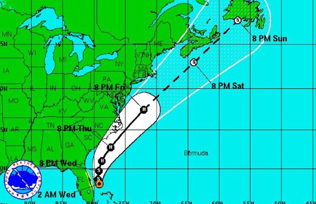
Wednesday morning Arthur was 200 miles southeast of Jacksonville, but the storm, according to the National Weather Service in Jacksonville, was on a path to remain far out at sea, tracking northeast and away from Florida, as well as other lands further north. The storm is expected to develop into a hurricane “over the next couple of days,” the weather service says.

That doesn’t mean swimmers and boaters should throw caution to what light winds will still breeze through the area: Flagler shores’ surf will see the impact of the storm, and rip currents will be very dangerous as Independence Day vacationers swarm the beaches.

“A tropical storm warning remains in effect for the Atlantic coastal waters 20-60 NM offshore,” the weather service warns. “We are expecting tropical storm conditions over the waters later today through tonight. A high risk of rip currents was issued for local beaches today. Squalls of showers and isolated thunderstorms will rotate onshore working their way northward through tonight. Gusty winds and brief locally heavy rainfall will be possible in these squalls. Rainfall amounts may near 1-2 inches along the immediate coast, especially south of St. Augustine through Thursday.”

Remarkably, the National Hurricane Center’s website was not accessible Wednesday morning.

Earlier Reports:

NOAA sent this afternoon update Tuesday, July 1: “At 2:00 p.m. EDT, Tropical Storm (TS) Arthur was located near latitude 27.9 north and longitude 79.4 west, or approximately 210 miles south-southeast of Mayport, Florida. This position is also about 150 miles southeast of Flagler Beach, Florida. TS Arthur is moving northwest at 5 mph. This general motion should continue through tonight, followed by a turn toward the north on Wednesday. The center of the tropical cyclone is expected to remain offshore and move east of the central Florida east coast during the next day or so. The system is forecast to pass 80 to 120 miles offshore of northeastern Florida on Wednesday and Wednesday night and about 120 to 140 miles east of southeast Georgia coast early Thursday morning. Tropical storm force winds extend outward up to 45 miles from the center. Conditions should allow for at least steady strengthening and TS Arthur is expected to become a hurricane offshore or near the Carolina Coasts by Thursday night and Friday morning.”

Earlier:

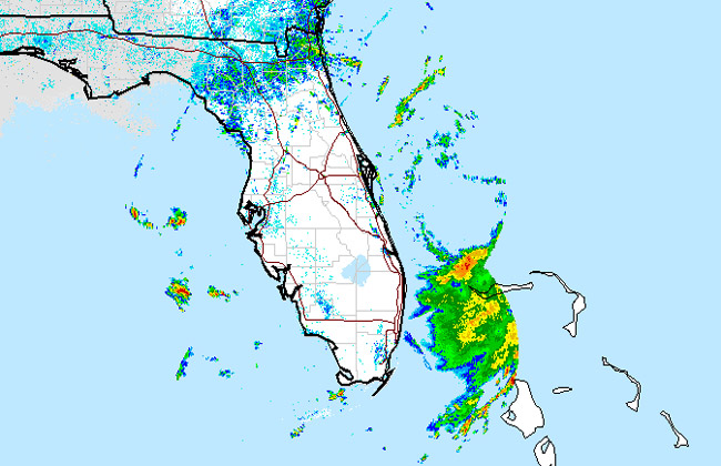
The first tropical storm of the season is organizing 170 miles southeast of Flagler Beach and is heading up the Florida coast, strengthening as it parallels it, with storms, wind and rain in Flagler County’s forecast starting late Tuesday night and through Wednesday.

Palm Coast’s Independence Day festivities the evening of July 3 may be affected, but probably not by much, with the chance of thundershowers diminishing considerably as the day wears on and almost disappearing by 9 p.m., when the fireworks are to be set off. There is a 40 percent chance of rain on July 4, which would affect Flagler Beach’s parade at mid-day, and its fireworks at 9:30 p.m. The parade is setting off rain or shine.

A storm surge is expected on Wednesday and Thursday along the coast, making for spectacular shore-watching. Waves are expected to reach 5 to 6 feet tonight and 7 to 9 feet Wednesday.

At 8 a.m. Tuesday, the storm was stationary, with winds of 35 miles per hour. “Conditions are favorable for this depression to develop into a Tropical Storm later today and then track north and northeast offshore the northeast Florida and southeast Georgia coast Wednesday night,” the National Weather Service in jacksonville said this morning. “Forecast models have come into good agreement with this storm strengthening to Tropical Storm strength as it moves northward while paralleling the southeast Atlantic coast through late Thursday.”


Scattered showers and thunderstorms are expected to begin to move onshore later today, edging their way northward up the Atlantic coast tonight through late Wednesday. Bands of showers and isolated thunderstorms will move onshore through Wednesday night, with locally heavy rainfall possible. Rainfall amounts of 1 to 2 inches are possible generally south of St Augustine through Thursday, with locally higher amounts. Gusty winds in squalls may reach up to 40 mph. Inland, rains should be lighter.

Mariners, swimmers and surfers beware. Northeast winds are expected to increase to tropical storm strength Wednesday and Wednesday night 20 to 60 miles offshore. Winds will increase up to 35 knots offshore with gusts up to 50 knots possible Wednesday through Wednesday night. Mariners are encouraged to continue to closely monitor this system. As onshore winds increase through midweek and swells build, the chance of dangerous rip currents along the coast will also increase. Today (Tuesday) here is a moderate risk of rip currents, with a high risk of rip currents expected on Wednesday. Breezy east-northeast winds will near 15-20 mph today and Wednesday with higher gusts.

As the storm moves north, the Georgia, South Carolina and North Carolina coasts are expected to feel the impact with bands of rain and gusts of wind. More significantly, the deteriorated weather will affect weekend travel along the I-95 corridor. Still, with the track of the storm less than certain, the forecasts are weaker the further they are from the day they’re made.

On its way. (NOAA)
On its way. (NOAA)
Support FlaglerLive's End of Year Fundraiser
Thank you readers for getting us to--and past--our year-end fund-raising goal yet again. It’s a bracing way to mark our 15th year at FlaglerLive. Our donors are just a fraction of the 25,000 readers who seek us out for the best-reported, most timely, trustworthy, and independent local news site anywhere, without paywall. FlaglerLive is free. Fighting misinformation and keeping democracy in the sunshine 365/7/24 isn’t free. Take a brief moment, become a champion of fearless, enlightening journalism. Any amount helps. We’re a 501(c)(3) non-profit news organization. Donations are tax deductible.  
You may donate openly or anonymously.
We like Zeffy (no fees), but if you prefer to use PayPal, click here.

Reader Interactions

Leave a Reply

Your email address will not be published. Required fields are marked *

This site uses Akismet to reduce spam. Learn how your comment data is processed.

  • Conner Bosch law attorneys lawyers offices palm coast flagler county
  • grand living realty
  • politis matovina attorneys for justice personal injury law auto truck accidents

Primary Sidebar

  • grand living realty
  • politis matovina attorneys for justice personal injury law auto truck accidents

Recent Comments

  • Edgar Williams on Palm Coast City Attorney Calls Mayor Norris ‘Unprofessional and Inappropriate’ 3 Weeks After Censure for Similar Behavior
  • Kennan on Israel’s Catastrophic Starvation of Gaza’s Millions
  • Jane Gentile-Youd on Dog Surfing Hilarity Conquers Flagler Beach as Chi-weenie, Corgis and Costumes Thrill to 4th Hang 8 Extravaganza
  • anonymous on An Ugly Town Meeting in Marineland as Questions Hang Over Legality of Mayor’s Unilateral Appointment of a Commissioner
  • The truth on Margaritaville’s Compass Hotel in Flagler Beach Opens in Buffett-Themed Celebration of a Downtown Remade
  • PeachesMcGee on Palm Coast’s Golden Chopsticks Buffet Open Again 2 Days After Sanitation Inspection Ordered It Closed
  • Roy on Margaritaville’s Compass Hotel in Flagler Beach Opens in Buffett-Themed Celebration of a Downtown Remade
  • PDE on Palm Coast’s Golden Chopsticks Buffet Open Again 2 Days After Sanitation Inspection Ordered It Closed
  • Ryan Jones on Margaritaville’s Compass Hotel in Flagler Beach Opens in Buffett-Themed Celebration of a Downtown Remade
  • Flagler Beach Resident on Margaritaville’s Compass Hotel in Flagler Beach Opens in Buffett-Themed Celebration of a Downtown Remade
  • Dusty on An Ugly Town Meeting in Marineland as Questions Hang Over Legality of Mayor’s Unilateral Appointment of a Commissioner
  • Nephew Of Uncle Sam on An Ugly Town Meeting in Marineland as Questions Hang Over Legality of Mayor’s Unilateral Appointment of a Commissioner
  • Pete on Margaritaville’s Compass Hotel in Flagler Beach Opens in Buffett-Themed Celebration of a Downtown Remade
  • Tony Mack on The Daily Cartoon and Live Briefing: Thursday, May 22, 2025
  • Joseph on Maga’s Fearful War on Universities
  • bruces on Palm Coast Mayor Norris Sues Palm Coast, Seeking Councilman Gambaro Booted and Special Election Held

Log in