• Skip to primary navigation
  • Skip to main content
  • Skip to primary sidebar
MENUMENU
MENUMENU
  • Home
  • About
    • Contact Us
    • FlaglerLive Board of Directors
    • Comment Policy
    • Mission Statement
    • Our Values
  • Live Calendar
  • Submit Obituary
  • Submit an Event
  • Support FlaglerLive
  • Advertise on FlaglerLive (386) 503-3808
  • Search Results

FlaglerLive

No Bull, no Fluff, No Smudges

MENUMENU
  • Flagler
    • Flagler County Commission
    • Beverly Beach
    • Economic Development Council
    • Flagler History
    • Mondex/Daytona North
    • The Hammock
    • Tourist Development Council
  • Palm Coast
    • Palm Coast City Council
    • Palm Coast Crime
  • Bunnell
    • Bunnell City Commission
    • Bunnell Crime
  • Flagler Beach
    • Flagler Beach City Commission
    • Flagler Beach Crime
  • Cops/Courts
    • Circuit & County Court
    • Florida Supreme Court
    • Federal Courts
    • Flagler 911
    • Fire House
    • Flagler County Sheriff
    • Flagler Jail Bookings
    • Traffic Accidents
  • Rights & Liberties
    • Fourth Amendment
    • First Amendment
    • Privacy
    • Second Amendment
    • Seventh Amendment
    • Sixth Amendment
    • Sunshine Law
    • Third Amendment
    • Religion & Beliefs
    • Human Rights
    • Immigration
    • Labor Rights
    • 14th Amendment
    • Civil Rights
  • Schools
    • Adult Education
    • Belle Terre Elementary
    • Buddy Taylor Middle
    • Bunnell Elementary
    • Charter Schools
    • Daytona State College
    • Flagler County School Board
    • Flagler Palm Coast High School
    • Higher Education
    • Imagine School
    • Indian Trails Middle
    • Matanzas High School
    • Old Kings Elementary
    • Rymfire Elementary
    • Stetson University
    • Wadsworth Elementary
    • University of Florida/Florida State
  • Economy
    • Jobs & Unemployment
    • Business & Economy
    • Development & Sprawl
    • Leisure & Tourism
    • Local Business
    • Local Media
    • Real Estate & Development
    • Taxes
  • Commentary
    • The Conversation
    • Pierre Tristam
    • Diane Roberts
    • Guest Columns
    • Byblos
    • Editor's Blog
  • Culture
    • African American Cultural Society
    • Arts in Palm Coast & Flagler
    • Books
    • City Repertory Theatre
    • Flagler Auditorium
    • Flagler Playhouse
    • Flagler Youth Orchestra
    • Jacksonville Symphony Orchestra
    • Palm Coast Arts Foundation
    • Special Events
  • Elections 2022
    • Amendments and Referendums
    • Presidential Election
    • Campaign Finance
    • City Elections
    • Congressional
    • Constitutionals
    • Courts
    • Governor
    • Polls
    • Voting Rights
  • Florida
    • Federal Politics
    • Florida History
    • Florida Legislature
    • Florida Legislature
    • Ron DeSantis
  • Health & Society
    • Flagler County Health Department
    • Ask the Doctor Column
    • Health Care
    • Health Care Business
    • Covid-19
    • Children and Families
    • Medicaid and Medicare
    • Mental Health
    • Poverty
    • Violence
  • All Else
    • Daily Briefing
    • Americana
    • Obituaries
    • News Briefs
    • Weather and Climate
    • Wildlife

Why Tornadoes Are Still Hard to Forecast

April 2, 2023 | FlaglerLive | 1 Comment

A tornado touches down. Morgan Schneider/OU CIMMS/NOAA NSSL

By Chris Nowotarski

  • grand living realty

Meteorologists began warning about severe weather with the potential for tornadoes several days before storms tore across the Southeast and the Central U.S. in late March 2023. At one point, more than 28 million people were under a tornado watch. But pinpointing exactly where a tornado will touch down – like the tornadoes that hit Rolling Fork, Mississippi, on March 24, and towns in Arkansas, Illinois and multiple other states on March 31 – still relies heavily on seeing the storms developing on radar. Chris Nowotarski, an atmospheric scientist, explains why, and how forecast technology is improving.

Why are tornadoes still so difficult to forecast?

Meteorologists have gotten a lot better at forecasting the conditions that make tornadoes more likely. But predicting exactly which thunderstorms will produce a tornado and when is harder, and that’s where a lot of severe weather research is focused today.


Often, you’ll have a line of thunderstorms in an environment that looks favorable for tornadoes, and one storm might produce a tornado but the others don’t.

The differences between them could be due to small differences in meteorological variables that aren’t resolved by our current observing networks or computer models. Even changes in the land surface conditions – fields, forested regions or urban environments – could affect whether a tornado forms. These small changes in the storm environment can have large impacts on the processes within storms that can make or break a tornado.

Scientists stand near a truck outfitted with measuring devices with a dramatic storm on the horizon.
One way scientists gather data for understanding tornadoes is by chasing storms.
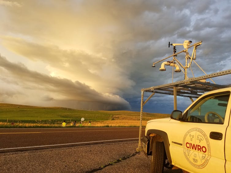
Annette Price/CIWRO, CC BY

One of the strongest predictors of whether a thunderstorm produces a tornado relates to vertical wind shear, which is how the wind changes direction or speed with height in the atmosphere.

How wind shear interacts with rain-cooled air within storms, which we call “outflow,” and how much precipitation evaporates can influence whether a tornado forms. If you’ve ever been in a thunderstorm, you know that right before it starts to rain, you often get a gust of cold air surging out from the storm. The characteristics of that cold air outflow are important to whether a tornado can form, because tornadoes typically form in that cooler portion of the storm.

How far in advance can you know if a tornado is likely to be large and powerful?

The vast majority of violent tornadoes form from supercells, thunderstorms with a deep rotating updraft, called a “mesocyclone.” Vertical wind shear can enable the midlevels of the storm to rotate, and upward suction from this mesocyclone can intensify the rotation within the storm’s outflow into a tornado.

If you have a supercell on radar and it has strong rotation above the ground, that’s often a precursor to a tornado. Some research suggests that a wider mesocyclone is more likely to create a stronger, longer-lasting tornado than other storms.


Forecasters also look at the storm’s environmental conditions – temperature, humidity and wind shear. Those offer more clues that a storm is likely to produce a significant tornado.

What radar showed as a tornado headed toward Rolling Fork, Mississippi, on March 24, 2023.

The percentage of tornadoes that trigger a warning has increased over recent decades, due to Doppler radar, improved modeling and better understanding of the storm environment. About 87% of deadly tornadoes from 2003 to 2017 had an advance warning.

The lead time for warnings has also improved. In general, it’s about 10 to 15 minutes now. That’s enough time to get to your basement or, if you’re in a trailer park or outside, to find a safe facility. Not every storm will have that much lead time, so it’s important to get to shelter fast.

What are researchers discovering today about tornadoes that can help protect lives in the future?

If you think back to the movie “Twister,” in the early 1990s we were starting to do more field work on tornadoes. We were taking radar out in trucks and driving vehicles with roof-mounted instruments into storms. That’s when we really started to appreciate what we call the storm-scale processes – the conditions inside the storm itself, how variations in temperature and humidity in outflow can influence the potential for tornadoes.

Scientists can’t launch a weather balloon or send instruments into every storm, though. So, we also use computers to model storms to understand what’s happening inside. Often, we’ll run several models, referred to as ensembles. For instance, if nine out of 10 models produce a tornado, we know there’s a good chance the storm will produce tornadoes.

The National Severe Storms Laboratory has recently been experimenting with tornado warnings based on these models, called Warn-on-Forecast, to increase the lead time for tornado warnings.

A destroyed home with just one wall standing and furniture strewn about in Rolling Fork, Mississippi, after the tornado March 24, 2023.
An early warning can be the difference between life and death for people in homes without basements or cellars.
Chandan Khanna/AFP via Getty Images

There are a lot of other areas of research. For example, to better understand how storms form, I do a lot of idealized computer modeling. For that, I use a model with a simplified storm environment and make small changes to the environment to see how that changes the physics within the storm itself.

There are also new tools in storm chasing. There’s been an explosion in the use of drones – scientists are putting sensors into unmanned aerial vehicles and flying them close to and sometimes into the storm.


The focus of tornado research has also shifted from the Great Plains – the traditional “tornado alley” – to the Southeast.

What’s different about tornadoes in the Southeast?

In the Southeast there are some different influences on storms compared with the Great Plains. The Southeast has more trees and more varied terrain, and also more moisture in the atmosphere because it’s close to the Gulf of Mexico. There tend to be more fatalities in the Southeast, too, because more tornadoes form at night.

US map showing highest number of tornadoes in Mississippi, Alabama and western Tennessee.
A map of severe tornado days from 1986 to 2015 shows a large number in the Southeast.
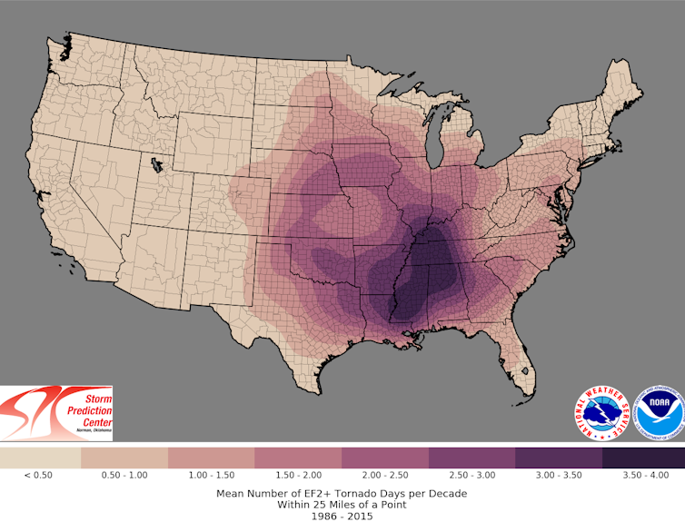
NOAA Storm Prediction Center

We tend to see more tornadoes in the Southeast that are in lines of thunderstorms called “quasi-linear convective systems.” The processes that lead to tornadoes in these storms can be different, and scientists are learning more about that.

Some research has also suggested the start of a climatological shift in tornadoes toward the Southeast. It can be difficult to disentangle an increase in storms from better technology spotting more tornadoes, though. So, more research is needed.

Chris Nowotarski is Associate Professor of Atmospheric Science at Texas A&M University.


The Conversation arose out of deep-seated concerns for the fading quality of our public discourse and recognition of the vital role that academic experts could play in the public arena. Information has always been essential to democracy. It’s a societal good, like clean water. But many now find it difficult to put their trust in the media and experts who have spent years researching a topic. Instead, they listen to those who have the loudest voices. Those uninformed views are amplified by social media networks that reward those who spark outrage instead of insight or thoughtful discussion. The Conversation seeks to be part of the solution to this problem, to raise up the voices of true experts and to make their knowledge available to everyone. The Conversation publishes nightly at 9 p.m. on FlaglerLive.

Previous Conversations:

  • Understanding the Heat Dome: Why America Is Baking
  • Endorsements Aren’t As Influential as You Think
  • Wiccan Celebrations and the Permanence of Change
  • Privacy Isn’t In the Constitution. But It’s Everywhere in Constitutional Law.
  • Anti-Trans Legislation and Lawsuits Are Pushing back Against Chosen Pronouns
  • How Mike Pence’s Unremarkable Actions on Jan. 6 Saved the Nation
  • Blaspheming Human Rights: The Hypocrisy at the Core of Authoritarian Muslim Nations
  • There Is No One ‘Religious View’ on Abortion
  • Inflation Is Spiking. Can the Fed Raise Interest Rates Without Spiking Unemployment, Too?
  • Blaming ‘Evil’ Is Not Enough
  • Did the 1994 Assault Weapons Ban Diminish Mass Shootings? Yes.
  • Crowded Primaries Are Good for Extremists, Bad for Voters
  • To Get Safe Schools, Mental Health Resources Are Critical
  • Antarctica’s Riskiest Glacier Is Losing Its Grip
  • The Legal Age to Buy Assault Weapons Doesn’t Make Sense

See the Full Conversation Archives
Print Friendly, PDF & Email
You and your neighbors collectively read our articles about 25,000 times each day (that's not a typo) with up to 65,000 daily reads during emergencies like hurricanes. Flagler County residents rely on FlaglerLive for essential, bold and analytical journalism that cannot be found anywhere else. But we depend on your support. Please join our December fund drive! If you donate the cost of a scoop of ice cream, you will be helping us continue to provide comprehensive local news and honest, serious journalism for our community. If you can donate more or become a monthly donor, even better. Donations are tax deductible since FlaglerLive is a 501(c)(3) non-profit news organization. Donate by clicking anywhere in this box. Think of it as buying a scoop, in every sense of the term!  
All donors' identities are kept confidential and anonymous.
   

Reader Interactions

Comments

  1. Courage says

    April 3, 2023 at 8:36 pm

    Watch the Flying Birds and Ground Animals….. If they hall ball it out of the area it’s a pretty good assumption that some “BAD VOODOO” is headed your way. And if you hear a train and some girl yelling “Auntie Em, Auntie Em” And you see this FUGLY looking witch on a broom screaming ” And your little dog too”………… Quickly dig a Big Ass hole and jump in !

    Reply
  • politis matovina attorneys for justice personal injury law auto truck accidents
  • grand living realty

Leave a Reply Cancel reply

Your email address will not be published. Required fields are marked *

Primary Sidebar

Advertisers

  • grand living realty
  • politis matovina attorneys for justice personal injury law auto truck accidents

Recent Comments

  • Pierre Tristam on Take Pride
  • Sherry on To Survive Poverty, Prayer Helped. But So Did Government.
  • pete on Behind the Divorce, a Bitter, Threat-Ridden Clash Between Waste Pro and Palm Coast Over Recycling Bins
  • Sherry on Take Pride
  • KS on Take Pride
  • Sherry on Take Pride
  • Mary Fusco on Take Pride
  • Nephew Of Uncle Sam on Take Pride
  • Eileen Curran-Bennett on Drag Queen Story Hour Is Not What You Think
  • Brian on Drunk Driver Allegedly Goes Nuts on Deputy After Crashing Into Hydrant
  • Pierre Tristam on Drag Queen Story Hour Is Not What You Think
  • DaleL on Its Streets Degrading, Palm Coast Looks for Electric Vehicles to Pay Their Fair Share of Road Taxes
  • Brian on Take Pride
  • oldtimer on Drunk Driver Allegedly Goes Nuts on Deputy After Crashing Into Hydrant
  • DaleL on Its Streets Degrading, Palm Coast Looks for Electric Vehicles to Pay Their Fair Share of Road Taxes
  • Pogo on The Daily Cartoon and Live Briefing: Monday, June 5, 2023

Log in