
If you have storm reports from your neighborhood or pictures, please text 386/503-3808. See previous Hurricane Milton reports here (Tuesday) and here (Monday).
Last Updated: 5:06 p.m.
Wednesday, 5:15 p.m. update–Torrential rain in Palm Coast ahead of Hurricane Milton has “severely overwhelmed” the city’s stormwater system, a city spokesperson said this afternoon.
Milton’s advance rain bands have led to a few high-water issues on four streets in the B Section, to city crews special-delivering sand bags to some residents, and to an alert from the city to residents to minimize water usage as the stormwater system is being overwhelmed by precipitation–with the worst yet to come.
The four streets with high water are Birchbark, Burning Bush, Burning Sands, Buttermill, and Burroughs, with high-water signs put up in several places, Brittany Kershaw, the city’s communications director, said after a 4 p.m. meeting of the city’s emergency operations center. Water levels are already 2 feet higher than normal, Kershaw said, “which makes it extremely difficult to get water out of the city because it doesn’t have anywhere to go.”
Floodwaters also caused the closure of a portion of State Road 100 in Bunnell, from East Woodland Avenue top Deen Road, with some reports of minor flooding elsewhere in the county. “Low lying areas seem to have some minor flooding,” the county’s communications manager, Karen Callahan, said in mid-afternoon. “There is some overflow issues at the N[orth] Anderson lidt station.”
Palm Coast’s B and L Sections drain into Pellicer Creek. “Pellicer Creek is full,” Kershaw said.
“We have our stormwater team out assessing and trying to remove blockages,” but because of the volume of water already in the city, there’s only so much the crews can do.
It’s not because of growth, recent or otherwise: the city would have been equally overwhelmed regardless. “This is just an unprecedented amount of water we’ve gotten in the lead up to this storm, and now we’re expecting 10 to 15 inches” more, Kershaw said–the largest amount for the region, according toa. report by Bradd Clark, the city’s assistant fire chief.
No homes in Palm Coast have experienced water intrusion–yet. But residents are concerned about water pooling in streets and yards, and saturation levels due to heavy rains for several days.
The city’s water levels are rising visibly. In Seminole Woods, a water-control structure for the North Ulysses Waterway–which extends north to Ullian Trail and Ulysses Lake–was below 18 feet at 9 this morning. By 3 this afternoon, it had risen to nearly 19 feet.
In the B Section, the Central Bellaire Waterway that extends north to Bird of Paradise Drive and south to Palm Coast Parkway was at 20 feet over the last 24 hours, then. rose above 21 between 7 a.m. an 1 p.m. today. It is 2 feet below cresting.
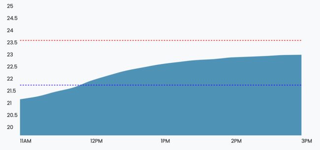
The Royal Palms Parkway weir, or control structure, west of Belle Terre Parkway, which flows with waters from US-1 to the Lehigh Trail, showed a sharp increase from 21 to 23 feet just between 11 a.m. and 3 p.m. today.
The rush of stormwater in the system led to an alert from city officials to city residents to conserve water: precipitations are straining the stormwater system. “To help protect our wastewater system and prevent overflows, we need your help,” the alert states. “Immediately conserve water by avoiding laundry, limiting showers, and flushing only when necessary.”
Bunnell issued a similar advisory: “Limit usage of water to ESSENTIAL needs only. Try to limit the water that is going down the drain now. With the rain fall already received and anticipated from the storm, limiting use now can help avert issues later.”
The worst is ahead: “We’re expecting from about 7 a.m. till about noon to be the worst of the storm for the city of Palm Coast,” Kershaw said, meaning 7 a.m. Thursday, “and the weather service did say that in Flagler County, our area, is going to get hit with the most rain. The wind is going to be on the other side of the storm.” She added: “We’re very well prepared, we feel like we’ve done everything we could do to this point.”
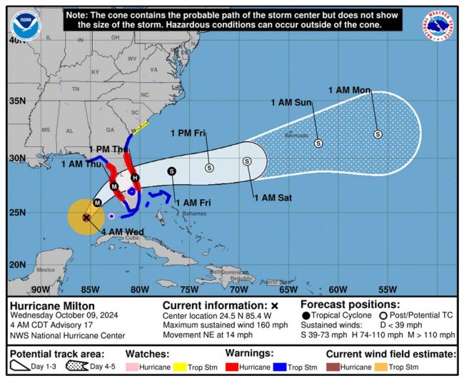
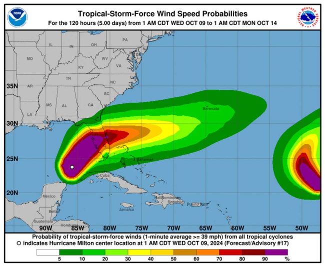
As of 5 p.m. today, Hurricane Milton was 60 miles west southwest of Sarasota and 170 miles from Orlando, with maximum sustained winds of 120 miles per hour, making it a Category 3 hurricane, and traveling at 17 miles per hour. “On the forecast track, the center of Milton
will make landfall near or just south of the Tampa Bay region this
evening,” the National Hurricane Center said at 5 p.m.
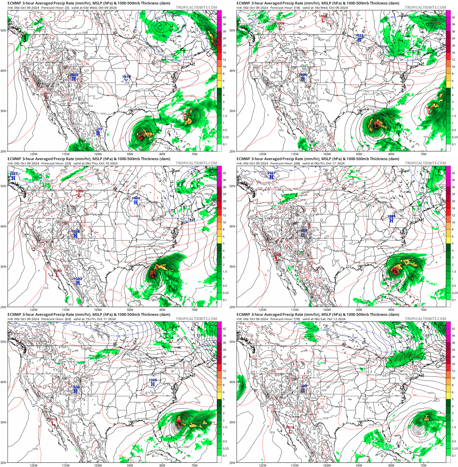
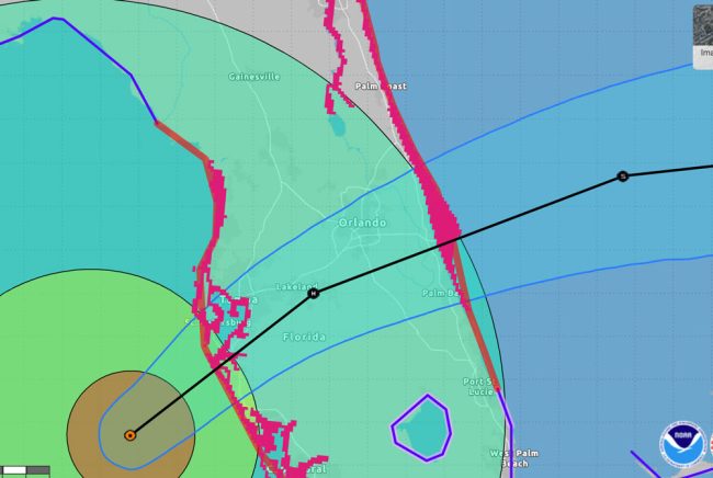
It will cross the peninsula over the next 10 to 12 hours, with maximum impacts in palm Coast from dawn to noon. Hurricane-force winds extend outward up to 35 miles from the center, while tropical-storm force winds extend up to 255 miles. Surge fears have been lowered to 6 to 9 feet in Tampa, but remain at 3 to 5 feet on the Atlantic.
Hurricane Milton Makes Landfall as Catastrophic Storm Tonight, Mandatory Evacuations of Flagler Beach and Other Areas at 8 AM Today
Wednesday, noon update—The National Hurricane Center’s 11 a.m. update on Hurricane Milton does not change the storm track, its warnings or its expected effects from Tampa Bay to the east coast of Florida, including Flagler County. The storm has weakened to 145 mph but remains a catastrophic Category 4 storm now moving faster, at 17 miles per hour, making landfall around midnight.
The storm is expected to reach the Atlantic coast faster, around 8 or 9 Thursday morning, and exit the peninsula faster, enabling more immediate responses in heavily damaged areas. Milton will remain a hurricane throughout, but ill be well offshore by 8 p.m. Thursday. As of 11 a.m., Milton was less than 200 miles from Tampa.
“Milton is likely to be a category 3 or 4 strength at landfall,” the National Hurricane Center says. “A slow decay in the winds is expected after landfall, but Milton is anticipated to move off the east coast of Florida on Thursday still as a hurricane.”
Mandatory evacuations are under way in many parts of Flagler County, including the entire barrier island–where residents are not quite heeding the warning–though almost none in Palm Coast. Rymfire Elementary is the shelter currently open and accepting residents who have left their homes.
Extremely heavy rain was already falling well before Hurricane Milton’s arrival. Palm Coast is expecting an additional 10 to 15 inches of rain over the next few days. Combined with the 6 inches of rainfall already received in the past five days, this ongoing weather event is likely to cause significant water accumulation in canals, ditches, swales, and roads throughout the city.
If you live in the L, Z, E, LL, B, W, R, P, or S sections of Palm Coast and have a PEP (Pretreatment Effluent Pumping) tank, it’s important to monitor your system carefully during the storm. If your power goes out, your PEP tank will not function, and you may experience wastewater backups. If this happens, immediately stop all water use, including flushing toilets and using sinks or showers.
If your PEP tank alarm goes off after power is restored, you can silence it by pressing the reset button located at the bottom of the control panel on the side of your home. If the alarm reactivates within 24 hours, please submit a case through Palm Coast Connect or call Customer Service.
Wednesday, 8:30 a.m.–Hurricane Milton, currently Category 5 with winds of 160 mph, will make landfall sometime late tonight or in the first hours of Thursday as a Category 3 or 4 storm in or just south of Tampa Bay then reach the Atlantic coast of Florida after barreling for a dozen hours through the heart of the state, from Sarasota to Melbourne, as a Category 3, 2 and 1 hurricane, its intensity diminishing the further east it goes, but its size growing the further east it goes. Its heaviest rains and wind impacts will be on its north side.
“Milton has the potential to be one of the most destructive hurricanes on record for west-central Florida,” the National Hurricane Center said this morning.
Hurricane-force winds will extend 30 miles from the center, while tropical-force storm winds will extend 125 miles from the center, placing Palm Coast and Flagler County in the northern storm zone, but no longer in the cone of probability of a direct hit. The maximum the eye of the storm may shift in predictions 24 hours from landfall, according to the National Hurricane Center, is 40 miles in either direction.
Nevertheless, the National Weather Center in Jacksonville is warning of tropical-storm force winds in the entirety of Flagler and St. Johns County that could range between 58 and 73 miles per hour, with hurricane-force gusts, and “extreme flooding rain” for large parts of Flagler County and the barrier island. Combined with saturated grounds, expect widespread downed trees and powerlines, power outages and damage to some homes and mobile homes. Those conditions will begin in Flagler County around midnight tonight and continue through Thursday evening. A Hurricane Warning is in effect in Flagler County.
“The cone got skinnier, so we’re actually outside of the cone,” Flagler County Emergency Management Director Jonathan Lord said this morning. “Now, our chances of having hurricane force winds have gone down, but they have not gone away. So that’s my huge caution. Just like it got skinnier, storms can shift, and literally it only takes a couple miles shift for us to be seeing these things. That’s really my big caution.”
Flagler County has ordered mandatory evacuations effective at 8 this morning for all residents in mobile homes and recreational vehicles anywhere in the county, for the entire barrier island, including Flagler Beach and Beverly Beach, for all the communities along South Anderson Highway, Polo Club West and Sweetbottom Plantation properties along Lexington Court / Ashland Way up to the Bulow Creek, all of the Marina del Palma properties along the Intracoastal, and on the mainland of Flagler Beach, all homes along Palm Drive and Lambert Avenue.
This may not be the final list. Emergency officials may add to it–as in fact they did this morning. The following areas are now required to evacuate as well: Flagler Estates and Methvin Road at the far northwest end of the county, where a handful of residents live. The concern there is flooding. Also, Durrance Lane / Strickland Road in Hunters Ridge at the south end of the county, and properties directly bordering Crescent Lake and Dead Lake at the west end of the county.
A curfew goes in effect in Flagler County at 7 this evening, until 7 a.m. Thursday. The curfew is countywide.
“Our deputies will use common sense, but don’t be surprised if you’re driving around or walking around after 7 p.m. and you’re not on your own property that you’re going to encounter a deputy sheriff to ask you why you’re out, and if you have a legitimate reason,” Sheriff Rick Staly said this morning. “There are some exceptions in the emergency order, to and from work for example, first responders, utility companies returning home from work, those kind of things are exceptions, and our deputies will use common sense.”
All schools, colleges, court activities, and most government offices are closed today and Thursday, garbage collections suspended.
“If it turns out that the evacuation is unnecessary we only know that after the fact, it’s better to be safe than sorry,” Scott Spradley, chair of the Flagler Beach City Commission, said early this morning. “It’s a wise move by the professionals at Emergency Management. It gives people the opportunity to see in living color that this is a real, potentially horrific event, and to take care of themselves and their families.”
Lord said this morning he has gotten no reports of congestion on the roads out of Flagler County. But since the evacuation order does not kick in until 8 a.m., it may be difficult to gauge just yet what the roads will look like.
Emergency officials have no intention of closing the State Road 100 bridge, but if and when winds reach a certain intensity, emergency responders will stop responding to calls until the storm’s intensity diminishes. That means people in the evacuation zone whop may have a medical or other form of emergency, including water emergencies, will not get help until it is safe for responders to travel.
A shelter opens at Rymfire Elementary, at 1425 Rymfire Drive in Palm Coast, at 8 this morning, for the general population, for special-needs patients, and for people with pets. The county has plans to open additional shelters if necessary. County officials are asking residents who intend to go to the shelter to do so before 7 this evening.
“Rainfall amounts of 6 to 12 inches, with localized totals up to 18 inches, are expected across central to northern portions of the Florida Peninsula through Thursday,” according to NHC, with predictions for Flagler-Palm Coast in the 6 to 8 inch range, and heavier localized amounts. Volusia County is expected to get heavier amounts.
The storm surge along coastal Flagler and the Intracoastal is predicted at 3 to 5 feet, and at 2 to 4 feet along the St. Johns River Basin, including Dead Lake and Crescent Lake to the west. The storm surge in Tampa Bay at landfall is predicted at 10 to 15 feet.
Hurricane Milton this morning was 300 miles southwest of Tampa, moving west northwest at 14 miles per hour, with wide swaths of rain already covering the midsection of Florida from Lake Okeechobee to the Big Bend area to the west and St. Johns County to the east.
Lord and Staly in an 8 a.m. press conference this morning sought to reassure the community that teams are in place to manage the emergency. “When it comes to disasters, natural or man made, whatever you are, we work as one team, regardless of the municipal jurisdiction, state government, county governments, all of the governments, the sheriff’s office, all the other constitutional officers,” Lord said. “We really do function as a unified team, because the end of the day, when a disaster is hitting our community, what’s on the side of your vehicle, your truck or on your shirt does not really matter. We’re all here to help our community. We have an amazing partnership. That’s what I love about our community. It’s all done as a partnership, including volunteer groups that come out and join us as part of this fight to make sure we can make it through whatever disaster is done in our community. It’s I think something every Flagler County resident and business should be very proud of.”




Jc says
Thank you so much for all your updates. You are doing a great job and it’s definitely appreciated.
Sherry says
Pierre is the “BEST’. . . he sincerely takes care of everyone in Flagler county!
Nephew Of Uncle Sam says
City kicked the can down the road for all the development yet laughed about infrastructure support. The chickens and roosters have come home to roost. Vote smart this time folks.
Pubic works guy says
That’s a Public Works guy in the photo
Joe D says
I share the previously mentioned Flagler Beach Commission member’s frustration that MANY Flagler Beach residents did not heed the MANDATORY (!?!) evacuation orders for 8 am Wednesday morning. Milton is going to bring an inordinate amount of rain into the Flagler Beach storm water system (especially since we have gotten 6” of rain to saturate the ground in the past week BEFORE we deal with ANY of Milton’s water). This is in addition to the prediction that it is likely going to remain a category 1 (not a tropical storm as previously thought)hurricane as it passes through Flagler Beach.
What are people THINKING!?! If you do not value your own ( and that of your family’s) lives, then think of the responders who will still attempt to risk their own safety to rescue you, if you suddenly realize, you made the wrong decision by not evacuating when directed!
As a retired Nurse, I’m SERIOUSLY concerned what will happen if the water level rises in Flagler Beach, along with the winds, making emergency access over the rt 100 bridge life threatening TO EMERGENCY RESPONDERS trying to rescue people who didn’t have the SENSE to follow EMERGENCY MANAGEMENT’S recommendations!
Seems like people have a short memory of the flooding from Nicole and the wind damage from Ian. Yes, there has been seawall and dune strengthening since then, as well as SIGNIFICANT improvements to the storm water drainage system, holding tanks, and collection systems since then, and the MAJOR source of water isn’t going to be from STORM SURGE in Flagler Beach. But the 8”-12+” of rain predicted for the area, has no where to REALLY go in that volume, except to re-flood the same areas in the southern end of the city, and along the waterways, as Nicole…and MILTON is confirmed as so much bigger and stronger than either Ian and Nicole.
I’ve only been a local homeowner since mid 2019, and I bought an (8 ft) elevated concrete townhouse with concrete slab floors and roof, but I’m not chancing my safety by ignoring EMERGENCY RECOMMENDATIONS.
People on the Barrier Island side of the route 100 bridge: if for some reason, the bridge is damaged or impassable…there are NO EMERGENCY TREATMENT FACILITIES on this side of the intercoastal! You are BASICALLY on your own…
Don’t take the chance!
Wow says
Just street flooding in FB or house flooding?