


Last Updated: 2:07 p.m.
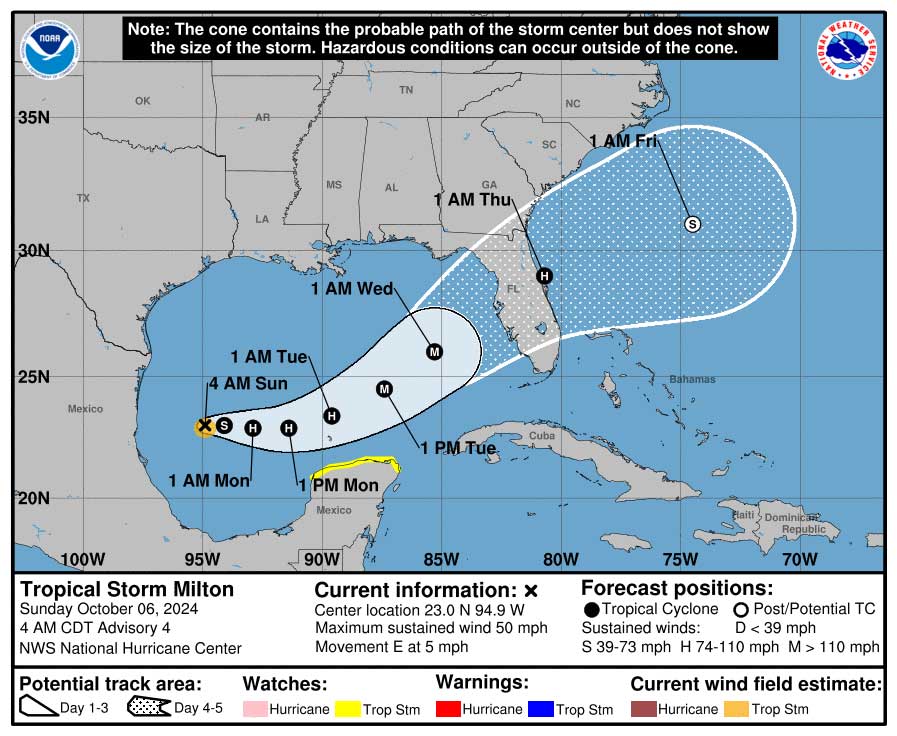
Eleven days after Hurricane Helene made landfall in Florida’s Big Bend, Tropical Storm Milton, which was expected to be Hurricane Milton by tonight, was rapidly gaining strength and is expected to become a major hurricane by Tuesday: it had gained hurricane strength by 2 p.m., with sustained winds of 80 mph–a faster transition than expected.
Hurricane Milton is mobilizing Florida from Tampa Bay through the north-central midsection of the state, including Flagler County, where severe conditions and impacts are expected.
The National Hurricane Center has a caveat: “Milton is a small cyclone, and such systems can both strengthen and weaken very rapidly.” But indications today are that the storm will strengthen rapidly then start moving rapidly toward the Florida Peninsula’s midsection, with areas of heavy rainfall impacting Florida today and Monday, well ahead of Milton, with even more heavy rainfall related to the storm Tuesday through Wednesday night.
As of Sunday morning, tropical-storm-force winds are expected in Flagler County late Tuesday night into Wednesday. The rainfall potential over the next five days for coastal Flagler County, including Flagler Beach and Beverly Beach, is in the 8 to 12-inch range, and in the 6 to 8 inch range for inland Flagler. The flash flooding potential is at least 40 percent for most of Flagler County. The heaviest rainfall potential is from Tuesday night through Wednesday night. Those figures are as variable as the track of the storm.
And in fact by 10 a.m. Sunday, the National Hurricane Center had shifted the track of the storm slightly south–not so significantly as to lessen the dangers the West Coast is facing around Tampa Bay, but enough to somewhat lessen the strongest wind impacts on Flagler County, but not necessarily the rain impacts.
Saturday evening, Gov. Ron DeSantis declared a state of emergency for 35 Florida counties, including Flagler, St. Johns, Volusia and Putnam counties.
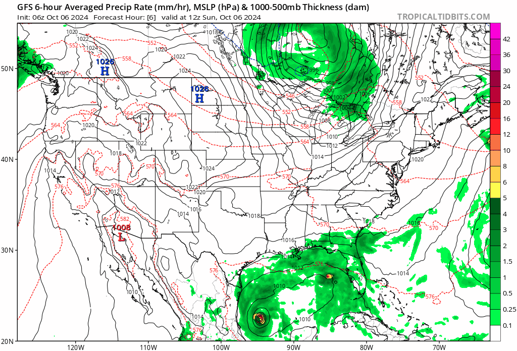
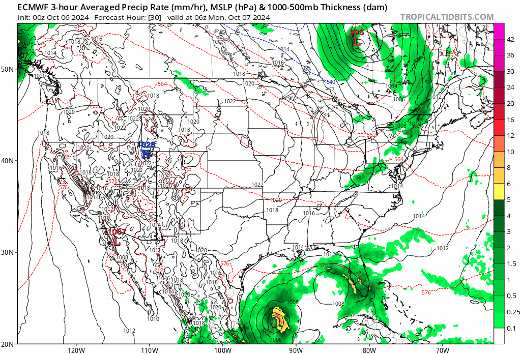
Milton’s current path has it making landfall as a Category 3 or 4 hurricane at midweek in Tampa Bay, then barreling roughly along the I-4 corridor either toward the Space Coast. Earlier today, the American model, known as GFS (Global Forecasting System), had it going slightly further north. The European model, known as ECMWF (European Centre for Medium-Range Weather Forecasts), has it edging further south. The American model has since adjusted toward the European model.
“There remains some spread in both the track and forward speed, so it is too early to specify which portions of the Florida Peninsula will get the worst impacts,” the National Hurricane Center notes this morning. “The new forecast track is nudged a little south of the previous track and lies between the GFS and ECMWF models. It should be noted that the average NHC track error at day 4 is around 150 miles.” That’s why forecaster repeatedly urge the public not to fixate on the storm’s exact track.
The National Hurricane Center currently has Milton as a hurricane when it exits the Florida Peninsula after midnight Thursday. Whatever path it takes, it is projected to be a violent, destructive storm bringing heavy rain and severe winds, with at least tropical storm conditions for Flagler County, and the potential for hurricane conditions, according to Jonathan Lord, Flagler County’s emergency management director. “I am definitely concerned,” he said.
The county’s Emergency Operations Center is getting activated Monday morning. “We are planning for a cat 1/2,” he said, referring to the strength of the hurricane on the 1-to-5 Saffir-Simpson Wind Scale. A Category 1 hurricane has winds of 75 to 95 miles per hour. A category 2 hurricane has winds of 96 to 110. A hurricane is considered “major” when it reaches Category 3, with winds of 111-129, which can cause devastating damage even to well-built frame houses. Category 4 and 5 (130 to 157 mph and higher) are in the “catastrophic” zone.
With wind damage and storm surge, both of which are expected to be severe, an added concern along the path of the storm is a ground saturated from persistent rain over the last few weeks. Saturated ground weakens trees ability to withstand severe winds and increase the likelihood of trees toppling over.
Here are the potential impacts in Northeast Florida and Southeast Georgia, according to the National Weather Center in Jacksonville:
-
- Regardless of development, in advance of the tropical system, persistent and gradually strengthening onshore winds will bring deteriorating marine, coastal and minor tidal flooding conditions the region, with nor’easter conditions.
- Tidal Flooding: Water levels will continue to increase within the St. Johns River basin this week due to the persistent onshore flow, with moderate tidal flooding possible by midweek.
- Surf Zone Hazards: High Rip Current risk and rough surf through at least Thursday. Beach erosion could be significant, which is always a concern with Flagler County’s fragile beaches, some of which have just been rebuilt–and have already seen significant erosion from Hurricane Helene.
- Marine Hazards: Small Craft Advisory conditions are possible for the outer waters as early as Monday morning.
- Gusty northeast winds will strengthen by Tuesday and Wednesday. Additional tree damage will be possible in northeast and north central FL, as many trees are already weakened post-Helene.
- Locally heavy rainfall is possible on Sunday, with increasing coverage and intensity on Tuesday and Wednesday, especially for coastal southeast Georgia and much of northeast and north central Florida.
- Preparations should be made on Sunday and Monday to secure any objects (weak structures, trees, etc) that are most susceptible to wind, rainfall, and elevated tides.
Local governments are expected to stand up sand-bagging operations and announce closures affecting operations at midweek, but likely not before Monday. This morning, Tropical Storm Milton was about 845 miles west southwest of Tampa, with sustained winds of 50 miles per hour, crawling east at 5 miles per hour. “Milton is forecast to become a hurricane
tonight, and it could become a major hurricane while it moves across the central and eastern Gulf of Mexico,” the National Hurricane Center predicts. But by 2 p.m., NHC was reporting that Milton had already gained hurricane strength with winds of 80 mph. It will be a major hurricane by Monday.
![]()
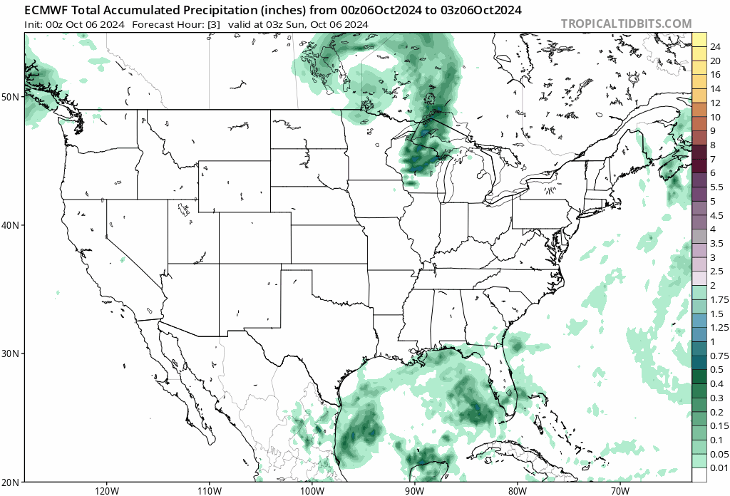
Here’s the expected total rain accumulation from Hurricane Milton over the coming week:


Joe D says
Good luck everyone. We were fortunate with Helene, that only mild storm effects hit Flagler Beach.
Looks like Milton isn’t going to be so “obliging.”
I find myself out is state for a family reunion, and won’t be back until AFTER Milton blows through. The worry about property damage when out of state is almost worse than when at home, because there is little I can do to protect my property remotely, beyond the usual (not letting loose items outside).
Prayers that everyone is safe through this NEW challenge.
Samuel L. Bronkowitz says
welp
JimboXYZ says
This one looks like a similar to Hurricane Ian (2022). Hoping that it crosses the state more level and stays below Tampa & Orlando, exits the Cape Canaveral wilds like Ian and continues level for that latitude line out into the Atlantic Ocean. Largo/Tampa to Daytona is 160+ miles, that should take some of the raging Cat 2/3 level down to a more manageable TS/Cat 1 storm as a best case sceanrio/model. Ian was a Cat 5 that hit Ft Myers, don’t recall what it was by the time it hit Cape Canaveral, but Ian turned North and pass4ed by us 60 miles off shore as a TS to later hit the Carolina coast as a Cat 1. I can’t imagine driving north far enough to get away & then turn around & drive back, what that traffic would be like, if there’s even enough gasoline for everyone to drive that. Back to growing FL so that evacuation is a miserable experience. And I’m going to say it, Biden-Harris border refugees, those millions more that end up being airlifted into higher density cities is a strain on the infrastructure & resources. It’s not nearly as bad when the sun shines most of the days of the year. But get this type of storm for an emergency situation and growing FL anywhere is a death sentence to those that make the list like we’re reading about in Asheville, NC. It’s bad enough citizens of America have what overpopulation & overutilization of resources. Try not to take this as solely blaming immigrants, just the scientific fact for a reality that growing more people regardless of race is not the solution to an area that is overpopulated. Here’s a good indicator of where they put people in FL, overlay the path of Milton & figure out that it doesn’t end well ?
https://i.pinimg.com/736x/75/90/44/759044b89475dba62dc216cc30fbe9e4–magnet-after-dark.jpg
Dem who cares says
If overpopulation and overpopulation are a concern to you, why do you support the party that does not believe in birth control, believes that childless people have no value to society, and prioritizes corporate profit over any concerns for human or environmental health?
Wind or water says
Don’t worry the republicons will ban hurricanes or just redraw them with sharpies. The key is that they guarantee insurance companies profits with your tax dollars.
datom says
Here we go again. Cat 4’s all the time now? and some don’t believe in climate change? There goes all the new beach sand. why do they think it won’t just wash away again over and over? As much as I was against this for a very long time, it may be time to be smart and Use the money for a permanent, solid concrete sea wall at this point, a one-time cost. The tide will still go out and there’ll still be some beach now and then. At least the beachside towns will be protected without the County going broke forever. And it becoming unaffordable to even be here if we bear the costs.