Last Updated: 7:18 a.m.
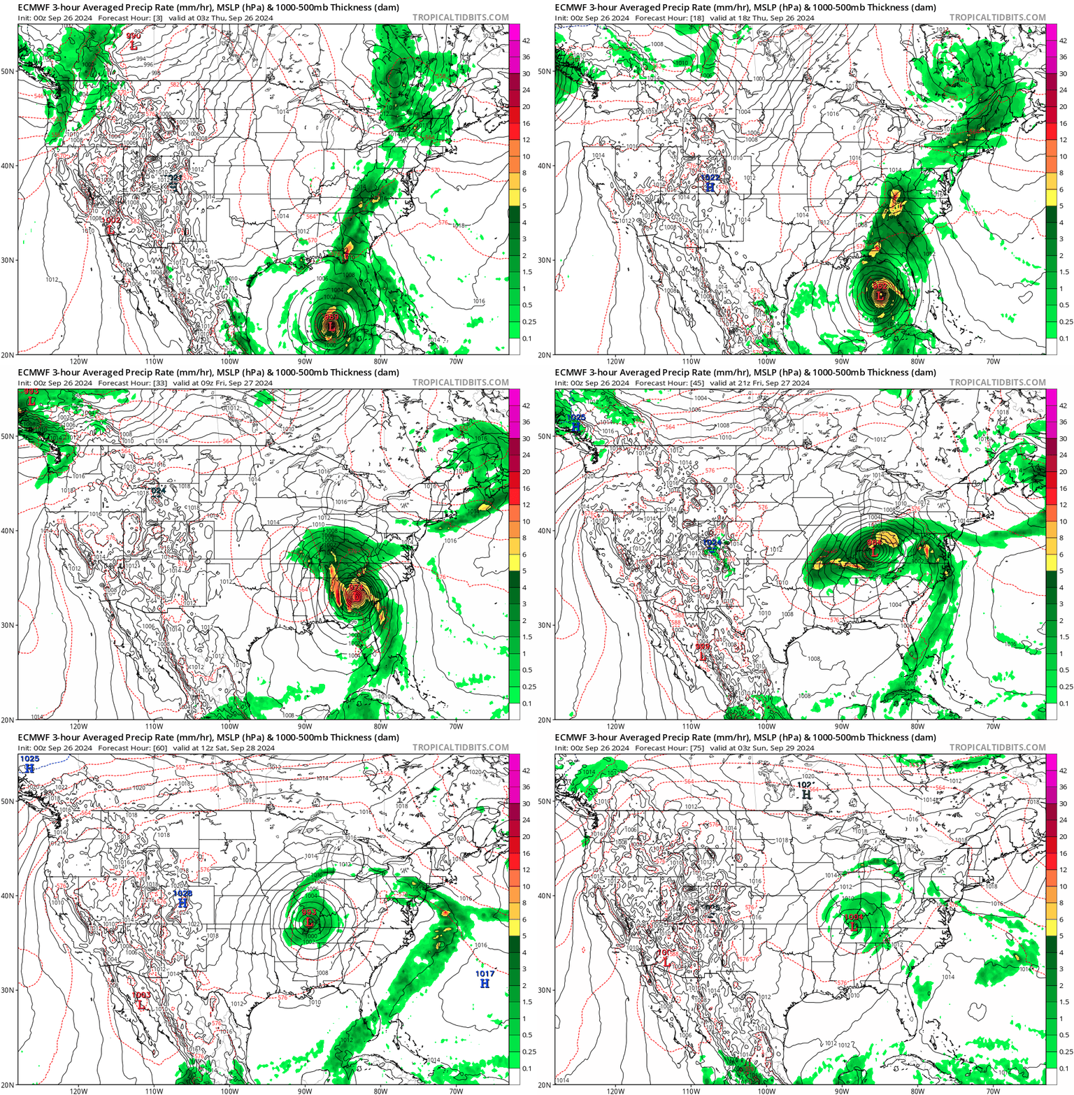
A dangerous Hurricane Helene with winds exceeding 111 miles per hour is expected to strike North Florida’s Big Bend region this evening. It will do so at a relatively fast forward speed, with two models forecasting that the eye of the hurricane will persist into southern Georgia, while its effects extend 200 miles across, with limited impacts in Flagler County. There is a slight local risk of tornadoes.
Models indicate Helene will make landfall Thursday night as a major hurricane in the same Big Bend region recovering from Hurricane Debby in early August and Hurricane Idalia in August 2023.
“A catastrophic and deadly storm surge is likely along portions of the Florida Big Bend coast, where inundation could reach as high as 20 feet above ground level, along with destructive waves,” the National Hurricane Center warns. “There is also a danger of life-threatening storm surge along the remainder of the west coast of the Florida Peninsula.”
In Northeast Florida, including Flagler County, outer rain bands will increase in frequency today, with stronger winds arriving after noon and local impacts increasing through Thursday night, the National Weather Service in Jacksonville says. But rain totals in coastal Flagler and Palm Coast are expected to be significantly less than in inland Flagler and counties further west and southwest: forecast models have coastal Flagler and Palm Coast receiving less than one inch, though localized thunderstorms may produce more. The flash flooding potential in Flagler is in the 5 to 15 percent range.
“I understand that we are under a tropical storm warning, but our offices are open for business, and we don’t anticipate many impacts,” County Administrator Heidi Petito told members of the Hammock Community Association, which is going ahead with a planned town hall meeting at 5:30 this evening at the Hammock Community Center “or impacted property owners regarding the ongoing beach and dune renourishment projects along the Hammock portion of Flagler County’s coastline.”
“Winds for Thursday are expected to range between 25 and 35 mph, and gusts of about 40 mph inland and 50 mph at the coast,” said Flagler County Emergency Management Director Jonathan Lord. “We do not anticipate that we will need to order evacuations or open shelters, but we do have a plan in place in case that needs to change.”
Flagler County provided self-service, bring-your-own-bag sand stations at Bay Drive Park, 30 Bay Drive, near the retention pond, and at Hidden Trails Community Center, 6108 Mahogany Boulevard. Palm Coast had sand and sandbags available for residents at the Indian Trails Sports Complex, 5455 Belle Terre Parkway. St. Johns County was providing free sandbags at half a dozen locations, but the public there was responsible for providing shovels and labor.

A hurricane warning was in effect from the Anclote River in the Pasco County area to Mexico Beach in Bay County. Tropical Storm Warnings are in in place in the rest of Florida, including Flagler, and a flash flood watch also continues for this entire area. Schools are closed in Flagler, Volusia and St. Johns counties, as are courts throughout the Seventh Judicial Circuit, which includes Flagler, Volusia, Putnam and St. Johns. All four counties are among the 61 out of the 67 counties in a declared state emergency.
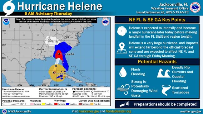
Hurricane Helene’s wind field will continue to expand, leading to significant impacts well beyond the Helene’s official track forecast cone. It is essential to monitor the overall impact rather than focusing solely on the forecast cone. Sustained tropical storm force winds are expected area-wide by Thursday afternoon and evening.
Dangerous marine and surf conditions will continue into Friday along the Atlantic coast, though with more serious effects in north Florida and Georgia. Around times of high tide, minor to moderate tidal flooding is expected along the St. Johns River and the Atlantic coast, particularly along coastal southeast Georgia. Water levels could rise to 3-4 feet above normally dry ground around high tide times from Thursday afternoon through Friday morning. This inundation will include docks, boat ramps, parking lots and some roads Thursday and Thursday night. The National Hurricane Center’s more precise forecast for the coast from the Flagler-Volusia County Line to to the South Santee River in South Carolina projects a storm surge of 1 to 3 feet–enough to heighten erosion of Flagler County’s newly renourished beaches.
If you are on the roads, hurricane force wind gusts are possible along and west of the I-75 corridor in the Suwannee Valley, western portions of north central Florida, as well as inland southeast Georgia, particularly as Helene accelerates northward and makes landfall on Thursday night.
Expected to rapidly intensify in the warm waters of the eastern Gulf of Mexico, Helene is projected to create storm surge throughout Florida’s Gulf Coast. A storm-surge warning was in effect from Flamingo in Monroe County to Indian Pass in Gulf County.
President Joe Biden on Tuesday approved an emergency declaration that authorizes federal money to help state and local efforts. It also gave authority to the Federal Emergency Management Agency to coordinate disaster relief. Earlier, DeSantis declared a state of emergency for 61 of Florida’s 67 counties.
About 18,000 utility workers are in position to help with restoring power, and DeSantis said that number will increase.
The Florida Municipal Electric Association said Wednesday its restoration workforce of 1,200 is being bolstered by more than 350 workers from nine states. Power outages, for example, could be a major issue in Tallahassee, which is served by a municipal utility.
Duke Energy Florida said it was readying 8,000 workers to respond to the storm. Also, crew members were coming from Duke Energy’s operations in Kentucky, Ohio and Indiana.
The Florida Department of Transportation lifted weight restrictions for utility and emergency response vehicles.
As of Wednesday morning, state Division of Emergency Management Kevin Guthrie–Flagler County’s former emergency management director–said Helene’s outer bands were already being felt across South Florida. “Please do not focus on the forecast cone,” Guthrie said, echoing words repeatedly spoken by Jonathan Lord, Flagler County’s emergency management director. “The hazards from this large storm, over 250 miles from the center, will be far, far reaching.”
At 4 Thursday morning Helene had sustained winds of 90 mph, was 350 miles southwest of Tampa and was moving north-northeast at 12 miles per hour. “Potentially catastrophic hurricane-force winds are expected within the eyewall of Helene when it makes landfall in the Florida Big Bend region later today,” the National Hurricane Center warned. Landfall is expected in the eastern part of the Panhandle as a Category 3 hurricane, with winds of between 111 mph and 129 mph.
The storm could tip into Category 4 status, which would be 130 mph to 156 mph, while over the Gulf of Mexico, according to AccuWeather. The Port of Key West was closed Wednesday morning, while vessel movement was stopped at the Port of St. Petersburg, Port Manatee and Port Tampa Bay.
The News Service of Florida contributed reporting.
![]()


Faster than expected says
Almost like something is making them speed up faster than before.