• Skip to primary navigation
  • Skip to main content
  • Skip to primary sidebar
MENUMENU
MENUMENU
  • Home
  • About
    • Contact Us
    • FlaglerLive Board of Directors
    • Comment Policy
    • Mission Statement
    • Our Values
    • Privacy Policy
  • Live Calendar
  • Submit Obituary
  • Submit an Event
  • Support FlaglerLive
  • Advertise on FlaglerLive (386) 503-3808
  • Search Results

FlaglerLive

No Bull, no Fluff, No Smudges

MENUMENU
  • Flagler
    • Flagler County Commission
    • Beverly Beach
    • Economic Development Council
    • Flagler History
    • Mondex/Daytona North
    • The Hammock
    • Tourist Development Council
  • Palm Coast
    • Palm Coast City Council
    • Palm Coast Crime
  • Bunnell
    • Bunnell City Commission
    • Bunnell Crime
  • Flagler Beach
    • Flagler Beach City Commission
    • Flagler Beach Crime
  • Cops/Courts
    • Circuit & County Court
    • Florida Supreme Court
    • Federal Courts
    • Flagler 911
    • Fire House
    • Flagler County Sheriff
    • Flagler Jail Bookings
    • Traffic Accidents
  • Rights & Liberties
    • Fourth Amendment
    • First Amendment
    • Privacy
    • Second Amendment
    • Seventh Amendment
    • Sixth Amendment
    • Sunshine Law
    • Third Amendment
    • Religion & Beliefs
    • Human Rights
    • Immigration
    • Labor Rights
    • 14th Amendment
    • Civil Rights
  • Schools
    • Adult Education
    • Belle Terre Elementary
    • Buddy Taylor Middle
    • Bunnell Elementary
    • Charter Schools
    • Daytona State College
    • Flagler County School Board
    • Flagler Palm Coast High School
    • Higher Education
    • Imagine School
    • Indian Trails Middle
    • Matanzas High School
    • Old Kings Elementary
    • Rymfire Elementary
    • Stetson University
    • Wadsworth Elementary
    • University of Florida/Florida State
  • Economy
    • Jobs & Unemployment
    • Business & Economy
    • Development & Sprawl
    • Leisure & Tourism
    • Local Business
    • Local Media
    • Real Estate & Development
    • Taxes
  • Commentary
    • The Conversation
    • Pierre Tristam
    • Diane Roberts
    • Guest Columns
    • Byblos
    • Editor's Blog
  • Culture
    • African American Cultural Society
    • Arts in Palm Coast & Flagler
    • Books
    • City Repertory Theatre
    • Flagler Auditorium
    • Flagler Playhouse
    • Flagler Youth Orchestra
    • Jacksonville Symphony Orchestra
    • Palm Coast Arts Foundation
    • Special Events
  • Elections 2024
    • Amendments and Referendums
    • Presidential Election
    • Campaign Finance
    • City Elections
    • Congressional
    • Constitutionals
    • Courts
    • Governor
    • Polls
    • Voting Rights
  • Florida
    • Federal Politics
    • Florida History
    • Florida Legislature
    • Florida Legislature
    • Ron DeSantis
  • Health & Society
    • Flagler County Health Department
    • Ask the Doctor Column
    • Health Care
    • Health Care Business
    • Covid-19
    • Children and Families
    • Medicaid and Medicare
    • Mental Health
    • Poverty
    • Violence
  • All Else
    • Daily Briefing
    • Americana
    • Obituaries
    • News Briefs
    • Weather and Climate
    • Wildlife

New Flood Maps Show US Damage Rising 26% in Next 30 Years

January 31, 2022 | FlaglerLive | 3 Comments

Coastal cities like Port Arthur, Texas, are at increasing risk from flooding during storms.
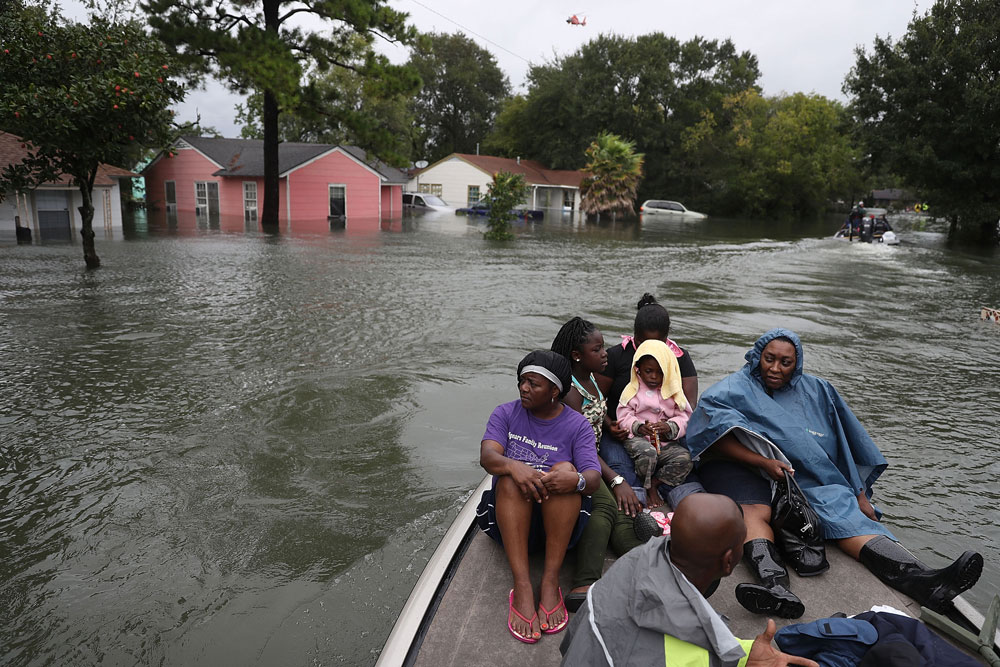
(Joe Raedle/Getty Images)

By Oliver, Carolyn Kousky, Jeremy Porter and Paul Bates

Climate change is raising flood risks in neighborhoods across the U.S. much faster than many people realize. Over the next three decades, the cost of flood damage is on pace to rise 26% due to climate change alone, an analysis of our new flood risk maps shows.


That’s only part of the risk. Despite recent devastating floods, people are still building in high-risk areas. With population growth factored in, we found the increase in U.S. flood losses will be four times higher than the climate-only effect.

Our team develops cutting-edge flood risk maps that incorporate climate change. It’s the data that drives local risk estimates you’re likely to see on real estate websites.

In the new analysis, published Jan. 31, 2022, we estimated where flood risk is rising fastest and who is in harm’s way. The results show the high costs of flooding and lay bare the inequities of who has to endure America’s crippling flood problem. They also show the importance of altering development patterns now.

The role of climate change

Flooding is the most frequent and costliest natural disaster in the United States, and its costs are projected to rise as the climate warms. Decades of measurements, computer models and basic physics all point to increasing precipitation and sea level rise.


As the atmosphere warms, it holds about 7% more moisture for every degree Celsius that the temperature rises, meaning more moisture is available to fall as rain, potentially raising the risk of inland flooding. A warmer climate also leads to rising sea levels and higher storm surges as land ice melts and warming ocean water expands.

Yet, translating that understanding into the detailed impact of future flooding has been beyond the grasp of existing flood mapping approaches.
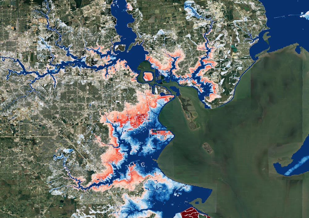
A map of Houston showing flooding extending much farther inland.
A map of Houston shows flood risk changing over the next 30 years. Blue areas are today’s 100-year flood-risk zones. The red areas reflect the same zones in 2050.
Wing et al., 2022

Previous efforts to link climate change to flood models offered only a broad view of the threat and didn’t zoom in close enough to provide reliable measures of local risk, although they could illustrate the general direction of change. Most local flood maps, such as those produced by the Federal Emergency Management Agency, have a different problem: They’re based on historical changes rather than incorporating the risks ahead, and the government is slow to update them.

Our maps account for flooding from rivers, rainfall and the oceans – both now and into the future – across the entire contiguous United States. They are produced at scales that show street-by-street impacts, and unlike FEMA maps, they cover floods of many different sizes, from nuisance flooding that may occur every few years to once-in-a-millennium disasters.

While hazard maps only show where floods might occur, our new risk analysis combines that with data on the U.S. building stock to understand the damage that occurs when floodwaters collide with homes and businesses. It’s the first validated analysis of climate-driven flood risk for the U.S.

The inequity of America’s flood problem

We estimated that the annual cost of flooding today is over US$32 billion nationwide, with an outsized burden on communities in Appalachia, the Gulf Coast and the Northwest.

When we looked at demographics, we found that today’s flood risk is predominantly concentrated in white, impoverished communities. Many of these are in low-lying areas directly on the coasts or Appalachian valleys at risk from heavy rainfall.


But the increase in risk as rising oceans reach farther inland during storms and high tides over the next 30 years falls disproportionately on communities with large African American populations on the Atlantic and Gulf coasts. Urban and rural areas from Texas to Florida to Virginia contain predominantly Black communities projected to see at least a 20% increase in flood risk over the next 30 years.

Historically, poorer communities haven’t seen as much investment in flood adaptation or infrastructure, leaving them more exposed. The new data, reflecting the cost of damage, contradicts a common misconception that flood risk exacerbated by sea level rise is concentrated in whiter, wealthier areas.

A woman carries a child past an area where flood water surrounds low-rise apartment buildings.
Hurricane Florence’s storm surge and extreme rainfall flooded towns on North Carolina’s Neuse River many miles inland from the ocean in 2018.
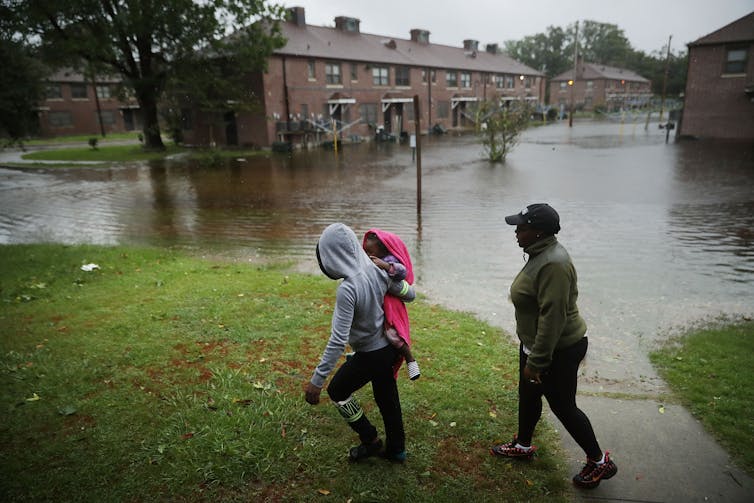
Chip Somodevilla/Getty Images

Our findings raise policy questions about disaster recovery. Prior research has found that these groups recover less quickly than more privileged residents and that disasters can further exacerbate existing inequities. Current federal disaster aid disproportionately helps wealthier residents. Without financial safety nets, disasters can be tipping points into financial stress or deeper poverty.

Population growth is a major driver of flood risk

Another important contributor to flood risk is the growing population.

As urban areas expand, people are building in riskier locations, including expanding into existing floodplains – areas that were already at risk of flooding, even in a stable climate. That’s making adapting to the rising climate risks even more difficult.
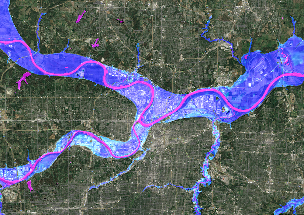
A satellite image of Kansas City showing flood risk overlaid along the rivers.
A Kansas City flood map shows developments in the 100-year flood zone.
Fathom

Hurricane Harvey made that risk painfully clear when its record rainfall sent two reservoirs spilling into neighborhoods, inundating homes that had been built in the reservoirs’ flood zones. That was in 2017, and communities in Houston are rebuilding in risky areas again.

We integrated into our model predictions how and where the increasing numbers of people will live in order to assess their future flood risk. The result: Future development patterns have a four times greater impact on 2050 flood risk than climate change alone.

On borrowed time

If these results seem alarming, consider that these are conservative estimates. We used a middle-of-the-road trajectory for atmospheric greenhouse gas concentrations, one in which global carbon emissions peak in the 2040s and then fall.

Importantly, much of this impact over the next three decades is already locked into the climate system. While cutting emissions now is crucial to slow the rate of sea level rise and reduce future flood risk, adaptation is required to protect against the losses we project to 2050.


If future development was directed outside of the riskiest areas, and new construction met higher standards for flood mitigation, some of these projected losses could be avoided. In previous research, we found that for a third of currently undeveloped U.S. floodplains it is cheaper to buy the land at today’s prices and preserve it for recreation and wildlife than develop it and pay for the inevitable flood damages later.

The results stress how critical land use and building codes are when it comes to adapting to climate change and managing future losses from increasing climate extremes. Protecting lives and property will mean moving existing populations out of harm’s way and stopping new construction in flood-risk areas.

Oliver Wing is a Research Fellow at the University of Bristol, Carolyn Kousky is Executive Director of the Wharton Risk Center at the University of Pennsylvania, Jeremy Porter is Professor of Quantitative Methods in the Social Sciencesat the City University of New York, Paul Bates is Professor of Hydrology at the School of Geographical Sciences, University of Bristol.

The Conversation arose out of deep-seated concerns for the fading quality of our public discourse and recognition of the vital role that academic experts could play in the public arena. Information has always been essential to democracy. It’s a societal good, like clean water. But many now find it difficult to put their trust in the media and experts who have spent years researching a topic. Instead, they listen to those who have the loudest voices. Those uninformed views are amplified by social media networks that reward those who spark outrage instead of insight or thoughtful discussion. The Conversation seeks to be part of the solution to this problem, to raise up the voices of true experts and to make their knowledge available to everyone. The Conversation publishes nightly at 9 p.m. on FlaglerLive.
See the Full Conversation Archives
Support FlaglerLive's End of Year Fundraiser
Thank you readers for getting us to--and past--our year-end fund-raising goal yet again. It’s a bracing way to mark our 15th year at FlaglerLive. Our donors are just a fraction of the 25,000 readers who seek us out for the best-reported, most timely, trustworthy, and independent local news site anywhere, without paywall. FlaglerLive is free. Fighting misinformation and keeping democracy in the sunshine 365/7/24 isn’t free. Take a brief moment, become a champion of fearless, enlightening journalism. Any amount helps. We’re a 501(c)(3) non-profit news organization. Donations are tax deductible.  
You may donate openly or anonymously.
We like Zeffy (no fees), but if you prefer to use PayPal, click here.

Reader Interactions

Comments

  1. Christopher Todd Lemke says

    February 1, 2022 at 8:55 am

    Another MOCKINGBIRD installment.

  2. Bartholomew says

    February 1, 2022 at 5:58 pm

    I don’t understand your comment

  3. Timothy Patrick Welch says

    February 1, 2022 at 6:02 pm

    Why does the Federal government continue to provide flood insurance?

    Its just another perk for the rich. And a waste of tax dollars.

    It enables the continued loss of paradise.

Leave a Reply

Your email address will not be published. Required fields are marked *

This site uses Akismet to reduce spam. Learn how your comment data is processed.

  • Conner Bosch law attorneys lawyers offices palm coast flagler county
  • grand living realty
  • politis matovina attorneys for justice personal injury law auto truck accidents

Primary Sidebar

  • grand living realty
  • politis matovina attorneys for justice personal injury law auto truck accidents

Recent Comments

  • Pig Farmer on 8,000 Homes, 800 RV Sites: Biggest Development Since Palm Coast Seeks Bunnell Commission Approval
  • John Orlando on Pam Richardson and Kim Carney Are Killing Flagler County’s Beaches
  • Karen P on 8,000 Homes, 800 RV Sites: Biggest Development Since Palm Coast Seeks Bunnell Commission Approval
  • I'm done on Pam Richardson and Kim Carney Are Killing Flagler County’s Beaches
  • Carol on In Palm Coast Town Hall, David Jolly Gives Local Democrats Something to Cheer About as He Readies Run for Governor
  • Robin on Pam Richardson and Kim Carney Are Killing Flagler County’s Beaches
  • Wtf on 8,000 Homes, 800 RV Sites: Biggest Development Since Palm Coast Seeks Bunnell Commission Approval
  • Ray W, on The Daily Cartoon and Live Briefing: Friday, June 6, 2025
  • FLF on 8,000 Homes, 800 RV Sites: Biggest Development Since Palm Coast Seeks Bunnell Commission Approval
  • JC on Pam Richardson and Kim Carney Are Killing Flagler County’s Beaches
  • Paul Larkin on Pam Richardson and Kim Carney Are Killing Flagler County’s Beaches
  • Stump Jumper on New Cell Towers Planned for Palm Coast Parkway East of I-95 and in Seminole Woods, as Business and Safety ‘Necessity’
  • Waste not on Without Prior Discussion, Palm Coast Council Approves $300,000 Plan Integrating City Surveillance with Sheriff’s Crime Center
  • Don on Pam Richardson and Kim Carney Are Killing Flagler County’s Beaches
  • Nope on 8,000 Homes, 800 RV Sites: Biggest Development Since Palm Coast Seeks Bunnell Commission Approval
  • Not our money worth on Pam Richardson and Kim Carney Are Killing Flagler County’s Beaches

Log in