


By Chris Vagasky
About 600 miles off the west coast of Africa, large clusters of thunderstorms begin organizing into tropical storms every hurricane season. They aren’t yet in range of Hurricane Hunter flights, so forecasters at the National Hurricane Center rely on weather satellites to peer down on these storms and beam back information about their location, structure and intensity.
The satellite data helps meteorologists create weather forecasts that keep planes and ships safe and prepare countries for a potential hurricane landfall.
Now, meteorologists are about to lose access to three of those satellites.
On June 25, 2025, the Trump administration issued a service change notice announcing that the Defense Meteorological Satellite Program, DMSP, and the Navy’s Fleet Numerical Meteorology and Oceanography Center would terminate data collection, processing and distribution of all DMSP data no later than June 30. The data termination was postponed until July 31 following a request from the head of NASA’s Earth Science Division.
I am a meteorologist who studies lightning in hurricanes and helps train other meteorologists to monitor and forecast tropical cyclones. Here is how meteorologists use the DMSP data and why they are concerned about it going dark.
Looking inside the clouds
At its most basic, a weather satellite is a high-resolution digital camera in space that takes pictures of clouds in the atmosphere.
These are the satellite images you see on most TV weather broadcasts. They let meteorologists see the location and some details of a hurricane’s structure, but only during daylight hours.
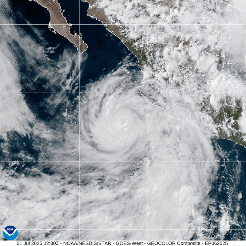
Meteorologists can use infrared satellite data, similar to a thermal imaging camera, at all hours of the day to find the coldest cloud-top temperatures, highlighting areas where the highest wind speeds and rainfall rates are found.
But while visible and infrared satellite imagery are valuable tools for hurricane forecasters, they provide only a basic picture of the storm. It’s like a doctor diagnosing a patient after a visual exam and checking their temperature.
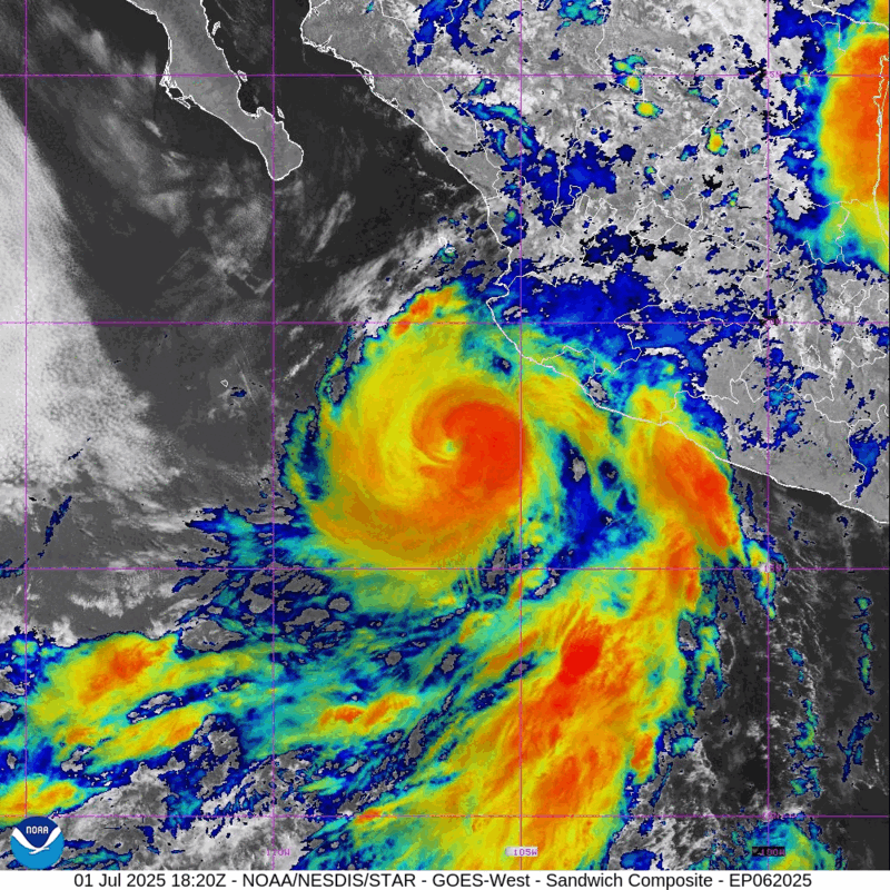
For more accurate diagnoses, meteorologists rely on the DMSP satellites.
The three satellites orbit Earth 14 times per day with special sensor microwave imager/sounder instruments, or SSMIS. These let meteorologists look inside the clouds, similar to how an MRI in a hospital looks inside a human body. With these instruments, meteorologists can pinpoint the storm’s low-pressure center and identify signs of intensification.
Precisely locating the center of a hurricane improves forecasts of the storm’s future track. This lets meteorologists produce more accurate hurricane watches, warnings and evacuations.
Hurricane track forecasts have improved by up to 75% since 1990. However, forecasting rapid intensification is still difficult, so the ability of DMPS data to identify signs of intensification is important.
About 80% of major hurricanes – those with wind speeds of at least 111 mph (179 kilometers per hour) – rapidly intensify at some point, ramping up the risks they pose to people and property on land. Finding out when storms are about to undergo intensification allows meteorologists to warn the public about these dangerous hurricanes.
Where are the defense satellites going?
NOAA’s Office of Satellite and Product Operations described the reason for turning off the flow of data as a need to mitigate “a significant cybersecurity risk.”
The three satellites have already operated for longer than planned.
The DMSP satellites were launched between 1999 and 2009 and were designed to last for five years. They have now been operating for more than 15 years. The United States Space Force recently concluded that the DMSP satellites would reach the end of their lives between 2023 and 2026, so the data would likely have gone dark soon.
Are there replacements for the DMSP satellites?
Three other satellites in orbit – NOAA-20, NOAA-21 and Suomi NPP – have a microwave instrument known as the advanced technology microwave sounder.
The advanced technology microwave sounder, or ATMS, can provide data similar to the special sensor microwave imager/sounder, or SSMIS, but at a lower resolution. It provides a more washed-out view that is less useful than the SSMIS for pinpointing a storm’s location or estimating its intensity.

U.S. Naval Research Laboratory, via Michael Lowry
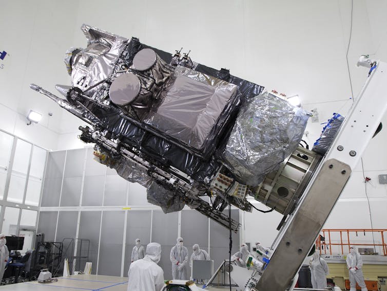
The U.S. Space Force began using data from a new defense meteorology satellite, ML-1A, in late April 2025.
ML-1A is a microwave satellite that will help replace some of the DMSP satellites’ capabilities. However, the government hasn’t announced whether the ML-1A data will be available to forecasters, including those at the National Hurricane Center.
Why are satellite replacements last minute?
Satellite programs are planned over many years, even decades, and are very expensive. The current geostationary satellite program launched its first satellite in 2016 with plans to operate until 2038. Development of the planned successor for GOES-R began in 2019.
Similarly, plans for replacing the DMSP satellites have been underway since the early 2000s.
NASA/Charles Babir
Delays in developing the satellite instruments and funding cuts caused the National Polar-orbiting Operational Environmental Satellite System and Defense Weather Satellite System to be canceled in 2010 and 2012 before any of their satellites could be launched.
The 2026 NOAA budget request includes an increase in funding for the next-generation geostationary satellite program, so it can be restructured to reuse spare parts from existing geostationary satellites. The budget also terminates contracts for ocean color, atmospheric composition and advanced lightning mapper instruments.
A busy season remains
The 2025 Atlantic hurricane season, which runs from June 1 to Nov. 30, is forecast to be above average, with six to 10 hurricanes. The most active part of the season runs from the middle of August to the middle of October, after the DMSP satellite data is set to be turned off.
Hurricane forecasters will continue to use all available tools, including satellite, radar, weather balloon and dropsonde data, to monitor the tropics and issue hurricane forecasts. But the loss of satellite data, along with other cuts to data, funding and staffing, could ultimately put more lives at risk.
![]()
Chris Vagasky is a Meteorologist and Research Program Manager at the University of Wisconsin-Madison.


Ric Flair says
Whew…thank goodness I can rest easy now…I thought it was 4.
don miller says
the european model has always been more accurate during hurricane season. These satellites are probably broken or obsolete but they won’t tell you that. Why? Because treacherous still bias media will say trump did it, then in same sentence say probably not. Then why mention it? TDS that is why.From the same gang that pretended they were fooled by Biden and his staff into thinking he was okay and then writes a book about how he was not the whole time. Why ever believe them again?
Me says
He will tell you it is Making If you think homeowners’ insurance isn’t expensive enough now wait it is going to get worse.
He is destroying the state he lives in and DeSantis is right along his side cheering him on.
Me says
Trumps way of Making America Great Again,
Lynne says
Bet the people along the Guadaloupe River in Texas are happy to hear this!!!!!
And those along the Atlantic Coast in the path of Tropical Storm Chantel!
And everyone who lives within 100 miles of any US coast – except for Florida: everyone there is happy with this decision!!
Bid Mike says
CONGRESS decided back in 2015 to retire DMSP, replacing it with newer platforms such as the Weather System Follow‑On Microwave (WSF‑M) and the Electro‑Optical/Infrared Weather System (EWS). The first WSF‑M satellite launched in 2024 and began operations in April 2025. Full operational capability, including direct data delivery to NOAA is still pending . Meteorologists will rely on these combined strategies—human reinforcements (NOAA was authorized to hire about 125 meteorologists and specialists to reinforce severely understaffed forecast offices ) , satellite redundancy, and procedural adjustments to navigate the gap left by DMSP’s termination. Scare tactics and blaming TRUMP for everything, maybe feeds your left viewership, but does a disservice to general readership.
Sherry says
WOW! We now have a new Maga expert on satellites and weather forecasting! Oh Oh. . .NOPE. . . just more Fox BS propaganda.
Satellites “probably broken”. . . not so fast. . .They are NOT broken! Also, where is trump’s “Big Beautiful Plan’ to replace them?
BTW. . . here is some additional “factual” information:
Impact on Weather Forecasting: Meteorologists have expressed serious concerns that this decision, especially concerning hurricane forecasting, could lead to a decline in forecast accuracy. The SSMIS instrument on DMSP satellites provides valuable data on storm structure and intensity, particularly at night. The loss of this data is seen as particularly troubling during hurricane season.
Alternative Data Sources Exist, But May Be Less Detailed: While other satellites have microwave instruments providing similar data, such as the ATMS on NOAA-20, NOAA-21, and Suomi NPP, they offer lower resolution and may not be as useful for pinpointing storm location and intensity.
Funding Cuts to Related Programs: Reports also mention BROADER BUDGET CUTS to NOAA, affecting research, grants, and satellite infrastructure, which could have long-term consequences for weather monitoring and climate modeling.
In summary, the Trump administration’s actions regarding DMSP satellites seem to center around ending the public distribution of their data due to concerns about cybersecurity and modernization, not because the satellites themselves are broken. However, this decision has caused concern among weather experts who rely on this data for critical forecasting, particularly for hurricanes.
Marlee says
responding to Me says…..
I thought it was MATA
Make America THINK Again!
(Good Protest sign!)
HayRide says
He didn’t the agency is replacing outdated technology with new equipment, it’s just properganger from the Mass Media giants, and the news rag(now checkout tabloid) just grabs headlines and mis informs it’s readers just for sensational headlines
Pogo says
@Note to MAGA crackpots and other trolls:
…the yellow fluid and blood weeping from your eyes and ears is normal for you; just ignore it — you’ll go away.
I didn’t attend the funeral, but I sent a nice letter saying I approved of it.
https://quoteinvestigator.com/2011/05/07/funeral-approved/
Laurel says
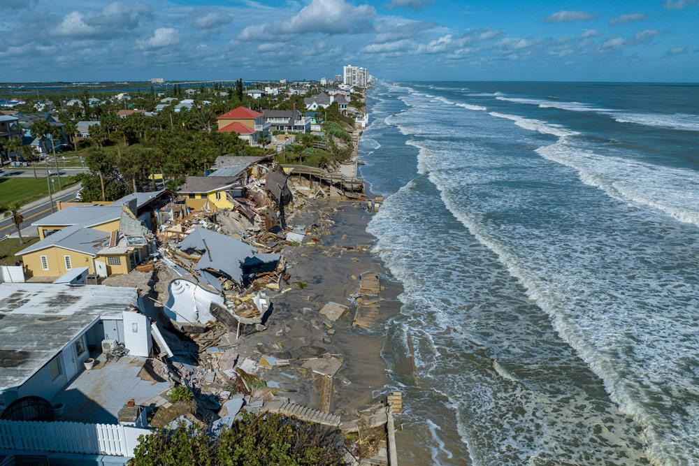
I remember my mom was always concerned about disturbances off the coast of Africa. That was what she would watch closely. We then had about 19 hours of warning, and preparing, figuring a storm was headed our way
It’s not the same anymore, there is far more concrete and far more poorly built buildings and homes. Our little house was common, and all concrete block. Some of the older homes were wood, but the wood was Miami-Dade Heart of Pine. Might was well have been concrete. Everyone had shutters. Later, I was living in Boca Ration when hurricane Andrew hit Miami, and wiped out those newly built, fragile homes. Should never have been allowed for developers to build those cracker boxes. That storm was what set the newly formed Miami-Dade code standards.
Today, a storm does not have to start off the coast of Africa, though it may, but very rapidly increase off our coast due to the warmed water. Yeah, it’s climate change whether you want to believe it or not.
It was surprising, that the trees one would think would survive, often didn’t. The massive ficus, with their multiple trunks would seem to be able to withstand anything, but even they would succumb to the wind, and wet ground, and topple over showing their massive roots high in the air. As kids, we climbed those roots. A1A, in Ft. Lauderdale, would be completely covered with beach sand, but not much flooding. Today, Miami Beach floods with regular King Tides.
This is not so good.
Don’t wait until the last minute. Your plans should be ready by now. If not, start planning! I already purchased all sizes of batteries on Amazon, and we’ve already stocked supplies. Get your meds and your pet’s meds and supplies. It’s just common sense. Even though there are generators, at homes, and at shopping, it’s better to be ready to get out of Dodge if your house cannot weather the storm.
With the current administration, you are on your own before, during and after the storm.
Ann Williams says
The President and the evil Regime behind him is destroying our country, our Republic, our Democracy.
LDRM says
It’s almost like he wants people to die and suffer! I am beyond wondering what he is thinking.
Sherry says
AI research reveals much better analysis than Fox BS:
While there are other weather satellites in operation, including NOAA’s GOES series and polar-orbiting satellites, concerns have been raised about whether these can fully replace the capabilities of the DMSP satellites.
Some replacements exist, but with limitations: Three other satellites – NOAA-20, NOAA-21, and Suomi NPP – have an advanced technology microwave sounder (ATMS) that can provide data similar to the DMSP’s special sensor microwave imager/sounder (SSMIS), but with lower resolution. This means it’s less effective for pinpointing storm locations or estimating intensity.
Newer satellites are available, but access to data is uncertain: The U.S. Space Force has a new microwave satellite called ML-1A, launched in 2024, which can help replace some DMSP capabilities. However, it’s unclear if or when the ML-1A data will be made available to forecasters like those at the National Hurricane Center. The WSF-M satellite, launched in 2024, also collects data that can be used to replace DMSP data.
Experts raise concerns about potential impacts: Meteorologists and climate scientists have expressed worry that the data loss could lead to less accurate forecasts, especially regarding hurricane intensity and tracking. They note that DMSP data has been crucial for understanding hurricane intensification, which has become more frequent due to climate change.
In summary, while some replacement satellites exist or are in development, questions remain about whether they can fully compensate for the discontinuation of DMSP data, and the availability of data from newer satellites is uncertain. The potential impact on hurricane forecasting, particularly regarding rapid intensification and track prediction, is a significant concern for meteorologists and coastal communities.
Marion Schneider says
Not all informatn in this article is correct, Vin Falcone, Richard Savage and I developed the first Microwave sounder to DMSP beginning in 1975. Aerojet was the contractor. Alx Stroygn was the maain person to do te physics of data retrieval., Originally DMSP depended on Infrared scanning Sounders but did not function well in the presense of clouds. The Infrared Sounders are no longer flown on DMSP.